1. NEW BAGS: Added Crown N1/Godmother (CN1), which has a height of 1408m, and a prominence of 158m. It's located at the west end of the ridge the ends to the NE at Mt Perrault; access is gained from the Hanes Valley Trail. Also Enchantment Peak (ENC) ((1444m)(P:114)), which is approached from the small unnamed lake just below and to the north of the Lions. We're eyeing some within-criteria peaks between CRO and PER, as well as the distant back-door bags of Bivouac and Eldee, but these are likely horrible and dangerous.
2. GROUP BAGS: we hope to run a few "guided tour" Flash Events throughout the summer. The remote and rewarding playground of Mt Capilano will be a likely destination.
3. GIFT BAGS: earn a star bag for doing an hour or so of trail maintenance (through trail flagging, sawing of limbs and suckers, pulling of ivy and holly, and other trail maintenance) during a bag.
4. GEOCACHE BAGS: earn a star bag for hiding (and then registering and being approved) (at Geocaching.com) a geocache on the summit or route.
WHAT: See how many North Shore peaks you can run up and bag in a summer. All but the island mountains qualify as munros (in excess of 3000 feet) under the Scottish peak-bagging system.
DATES:
Mainland peaks: June 23, 2013 to October 24, 2013 at 6:30pm
Howe Sound island peaks and Spring Bag front-row peaks (ONLY): April 1, 2013 to October 24, 2013 at 6:30pm
WHERE: non-technical or less-technical (Class 3 or easier) North Shore mountains (listed below). The peak must have its own name AND it must have a prominence of at least 50 metres (i.e. to climb to the next peak one must first descend at least 50 metres).
RESULTS: Post a comment setting out your mountainous conquests (or email "David Crerar" via the CFA Message email service on this site (see left column)), with the dates, and I will post ongoing standings. Please also feel free to post your trip reports in your CFA blog (log in and go to www.clubfatass.com/node/add/bog).
YOUR STORIES: CFA and your fellow Baggers love to hear about your Bagger Adventures. To share your stories, we recommend you blog about them in your CFA member blog. Log in, then go here to get started. You can read about the 2012 adventures posted so far here.
PHOTOS: Please post your photos, too. Add to the CFA Flickr Pool (instructions here. It's easy!), tag your photos: ClubFatAss ClubFatAssEvents ClubFatAssEvents2013 BaggerChallenge2013 BaggerChallenge (with a space separating each tag on the flickr template)
2013 Photos
Photo Archives
STAR BAGS: certain extraordinary methods of bagging will earn the bagger a coveted double-star after the peak, which stars will count as tie-breakers in totals. There are three kinds of star-bags, all of equal weight:
a. WATERBAGS: An ascent up a single peak linking sea level to summit counts as a waterbag. Only one peak per sea level ascent. e.g.: Dip toe in ocean at Ambleside Beach. Run up Capilano Trails and Nancy Greene Way and Grouse Grind. Summit Grouse, Goat, and Crown = 1 waterbag, not three. So long as culmulative height of peak is accomplished in single trip, a star is earned.
b. TRUE BAGS: as the true peaks of Crown and Gotha are semi-exposed, and there is a false summit very close, attaining the false peak will get you the point, and attaining the true peak will be starred.
c. GIFT BAGS: during a bag, doing an hour or so of trail maintenance (through trail flagging, sawing of limbs and suckers, pulling of ivy and holly, and other trail maintenance) will be starred.
d. GEOCACHE BAGS: during a bag, hiding (and then registering)(at Geocaching.com) a geocache on the summit or route.
SPRING BAGS:in addition to the Howe Sound Island peaks, we've opened up the "front row" of more easily-accessible peaks to the April starting date, for anyone who wants to try a snowshoe bag. ONLY TRY IN CLEAR WEATHER and ALWAYS CHECK THE AVALANCHE REPORTS and BRING THE PROPER EQUIPMENT and BE CAUTIOUS!: BLA, HOL, STR, GRO, DAM, FRO, SLY, LYN, SEY, SUI, DEP (NOT GOA, which has a nasty sheer drop which has claimed several lives in the winter).
WINNING TIE-BREAKER MECHANISM: In the case of a tie for first place:
1. the bagger with the most starbags (i.e. 1. water bags (i.e. peaks ascended from sea level to peak: see below) 2. true bags (i.e. true summits of GOT and CRO), 3. gift bags (i.e. trail work)) will win;
2. if still a tie, the bagger with the most unique bags (i.e. peaks that no one else visited) will win;
3. if still a tie, the bagger with the most write-ups and comments posted on the CFA Flickr website will win;
4. if still a tie, the bagger with the most photos posted on the CFA Flickr website will win;
5. if still a tie, the bagger with the most obscure/difficult bags (at the completely arbitrary discretion of the host) will win.
PRIZES: The winner will be the proud bearer of the CFA Bagger Munro Quaich cup for the year: the appropriate cup from which to drink a winter whisky and contemplate how awesome you are. There will be an auxiliary prize for the person who draws the most other people into the cult of peak-bagging. For other prizes, see below.
BAGGERS' BANQUET: To cap off the bagging season, we will either have a get-together at a pub, or else a barbeque for all bagger participants and their significant others. The Bagger Quaich will be awarded.
Date: Friday, October 25, 2013. 6pm - 10pm.
Place: t.b.a.
NO SANDBAGGING: all claims to bagging a peak must be submitted as promptly as possible (in most cases, within 3 days) of the actual climb. Climbs of more than two weeks old will be stale-dated for baggers already in the contest. Old bags by new baggers will be considered on a case-by-case fairness basis at the sole discretion of the administrator: late bags by new baggers late in the season will likely not be counted.
ARCHIVES
2012 Munro Quaich: Bill Maurer: 57 (i.e. ALL) peaks
2012 Pippa Quaich: Carolyn King: 21 peaks
2012 Harry Quaich: Harry Crerar: 15 peaks
2012 Tundra Quaich: Tundra the Ultra Dog: 18 peaks
2012 Twisted Quaich: Team Dagg and Team Healey-Thorpe
ENTRY: There is no fee and you don't need to be a member of Club Fat Ass to participate in a Flash event, however whining is not allowed. That being said, many of the peaks listed should only be attempted by those with the experience and fitness level of a typical Club Fat Ass member (i.e. ample mountain running experience over long distances).
IMPORTANT SAFETY CONSIDERATIONS: All of these adventures are potentially dangerous.
You are responsible for your own well being and safety and should be self sufficient.
Here are two useful lists of "MUST HAVE" survival items that all participants should carry:
Mountains marked with a !!! are scramble ascents or otherwise exposed or otherwise remote and undeveloped and should only be attempted by experienced climbers wearing helmets, etc. Don't try these routes in anything but perfect weather.
Use great caution when rocks are wet -- slipping is the cause of most accidents on North Shore mountains.
Always run/hike with a buddy.
CFA reserves the right to remove anyone from the Challenge for doing reckless, dangerous, destructive, or foolish actions.
PARTICIPATE AT YOUR OWN RISK: YOU ARE WAIVING LEGAL ACTION: By participating in this event you agree to be wholly responsible for your own well-being and agree not to sue anyone associated with this event or Club Fat Ass or any person in relation to this activity. By participating in this event you agree to the terms of the Release of All Claims.
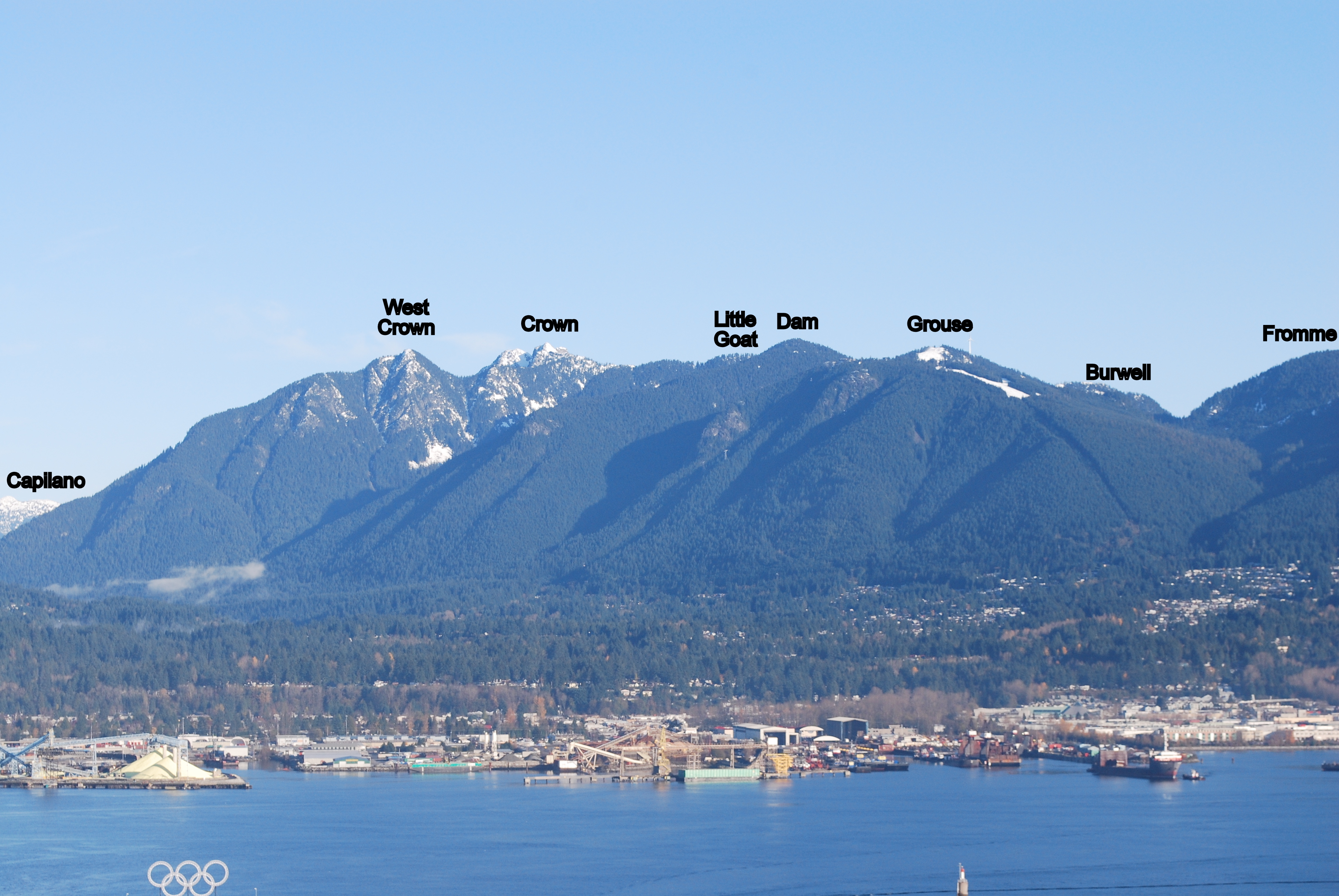
THE 59 NORTH SHORE PEAKS (ranges from west to east)
Altitude listed first, in brackets (metres)
# = Top-12 highest peak
P= Prominence (distance one must first descend before climbing next peak)
[[[ = NOT AN OFFICIAL PEAK in the Bagger Challenge, due to real exposure. Should only be attempted by experienced and competent alpinists. Attaining one of these peaks will nonetheless count as a bagger point.]]]
Peak notes (in round brackets at end)
peaks in italics indicate those baggable from April 1st.
for greater certainty peak ("pk") location among several possible summits (North,South, East, West)
*** as the true peaks are semi-exposed, and there is a false summit very close, attaining the false peak will get you the point, and attaining the true peak will be starred and count as a starbag (i.e. a tie-breaker).
e.g. the proper peak of Crown is a hair-raising wedge of rock with an impressive drop on 3/4 sides; attaining the (unscary) platform just below this true summit will get you a point).
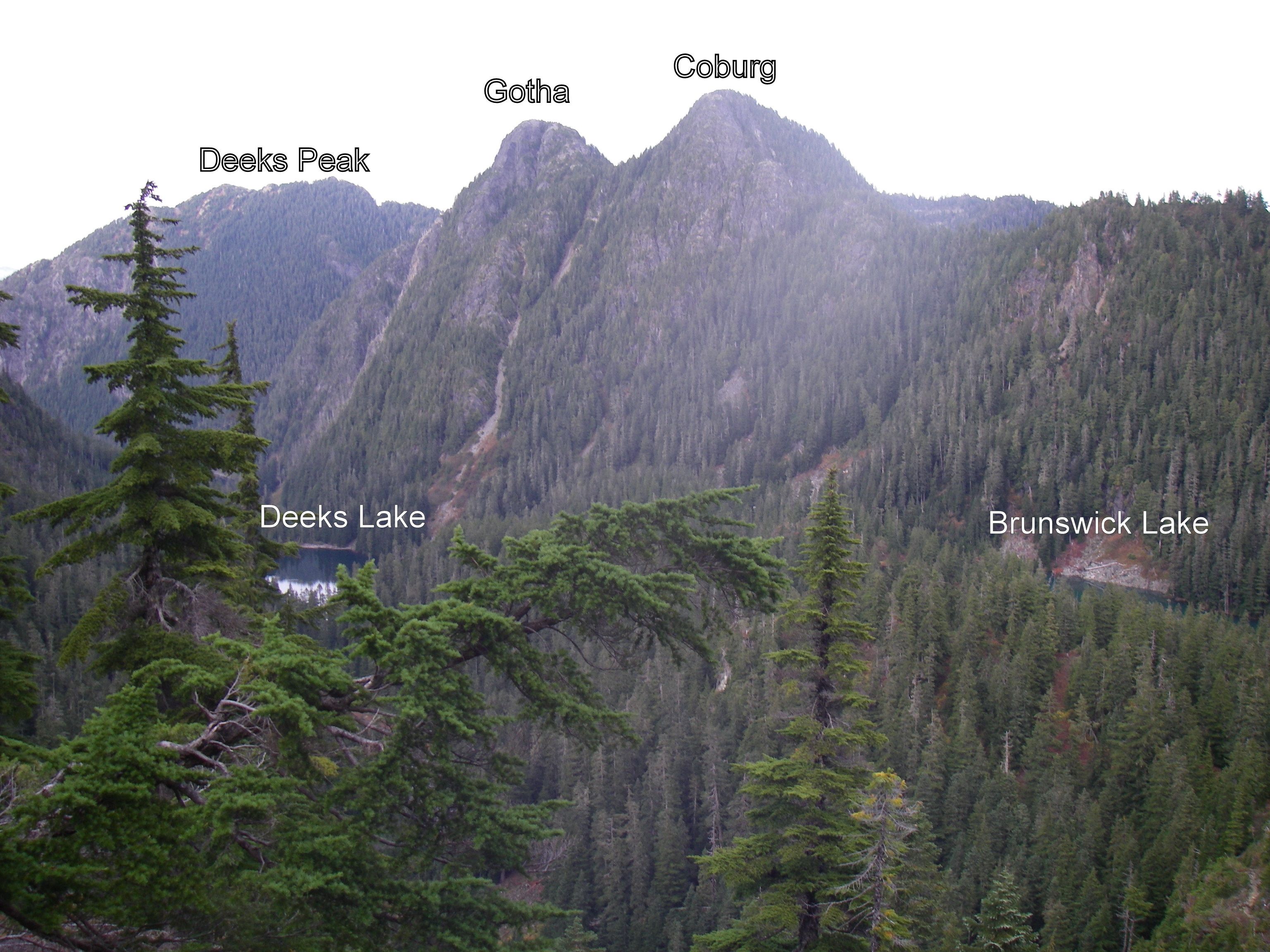
e.g.2 the proper peak of Gotha is the south peak, which is a semi-hair-raising traverse above a semi-sheer drop into Deaks Lakes way below; attaining the northern peak, with nearly identical height, will get you a point.
Resources and hyperlinks
103 = Bryceland & Macaree, 103 Hikes in Southwest British Columbia
MG = Matt Gunn, Scrambles in Southwest British Columbia
DH = Dawn Hanna, Best Hikes and Walks of Southwestern British Columbia
12= trip reports and maps
AB= peak photos
Note: the links to trip reports won't work unless your page is set to "50 comments per page" (the default setting)
Difficulty and Quality Rating {purple; in fancy brackets}
Difficulty: Hard; medium; easy
K = best hikes for kids
!!! = Dangerous: exposed or real risk of falling rock
!!!!!!!!! = Very dangerous; experienced mountaineers only
&& = trail at times faint or nonexistent; need route-finding skills
Quality: 1-5, with 1 being the best and 5 the worst
For a guided tour of the Bagger Peaks on Google Earth please click download the file attached below and open with Google Earth (and try the 3D flight simulator option under "tools"!)
For a full size Bagger map click on the image below:
Map by David Crerar; kindly and capably updated by Richard Macdonald
With mere hours left in the 2013 Bagger Challenge, I set out in an attempt to keep the Schmitz at bay. I'd heard that Marc was planning a trip to secure his twentieth piece of baggage for the season and my fragile ego couldn't take it. If he tied me, his starbags would propel him by me in the standings. I had to act fast.
Starting from the Cypress parking lot, I headed out on the Baden Powell (where I promptly fell on my face and scraped both knees) to the Mount Strachan Trail, past the plane crash and on to the North Peak of Mount Strachan. After a few minutes soaking up the views and feeding a couple Whiskeyjacks, I headed down to the Howe Sound Crest Trail by way of Christmas Gully and back to where I'd started. It was a bluebird day and a beauty way to wrap up the Bagging season.
Submitted by David Crerar on 22 October, 2013 - 19:20.
At the Bagger Banquet, we'll do a glorious slide show of bagging adventures this year.
Please post your photos, too. Add to the CFA Flickr Pool (instructions here. It's easy!), tag your photos: ClubFatAss ClubFatAssEvents ClubFatAssEvents2013 BaggerChallenge2013 BaggerChallenge (with a space separating each tag on the flickr template)
a) escape into the sunshine above fog-enveloped Vancouver
b) take a route up to the Howe Sound Crest Trail that I had not previously tried
c) snag a couple of peaks in my final bagging expedition of the season
Leaving the Lions Bay trailhead parking lot at 7:15am, I met objective a) by the time I got halfway up the logging road, as by then it was already late enough and high enough for the sun to be out. Beautiful day ahead.
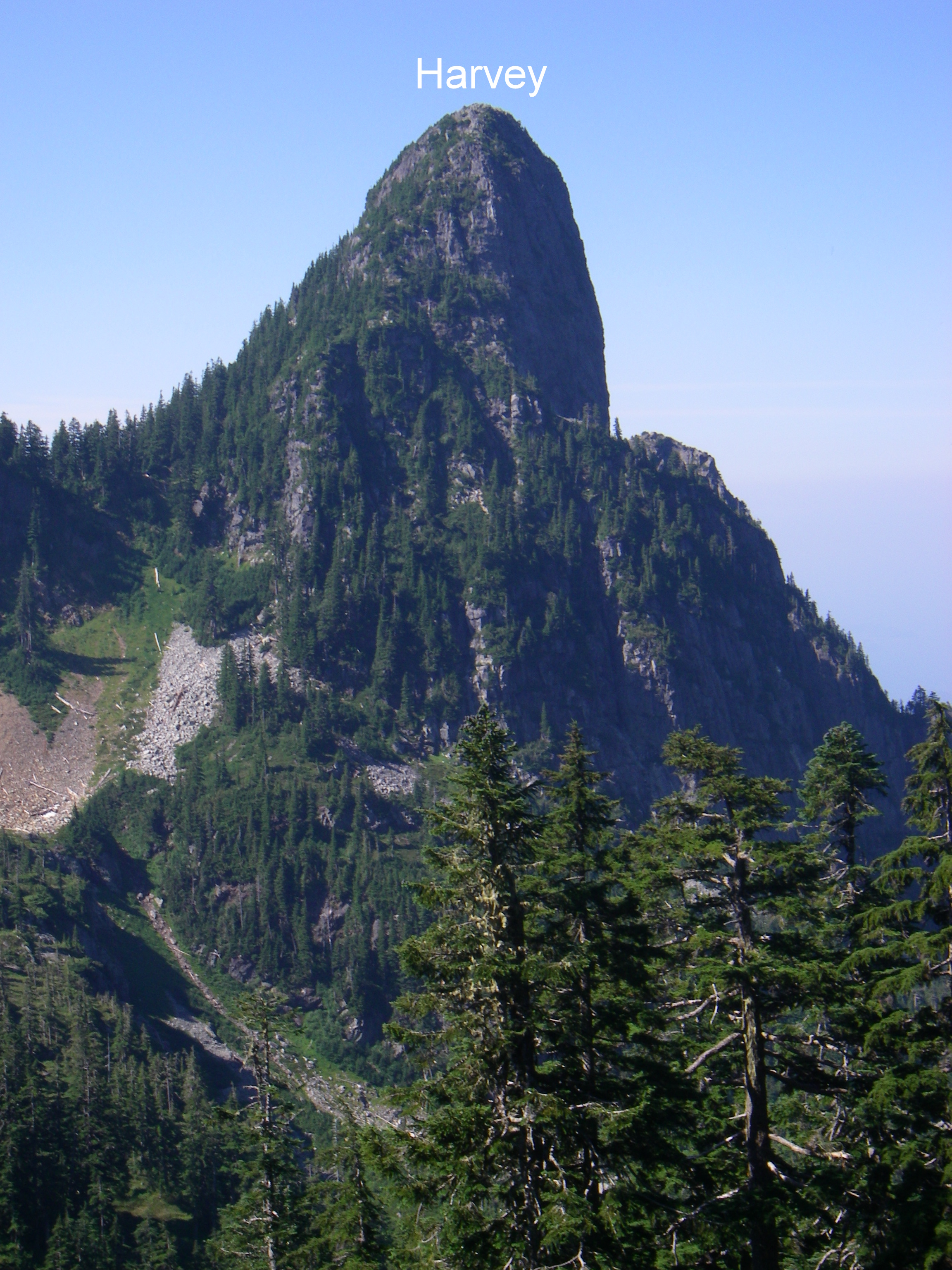
As far as I know, there are 6 ways up to the HSCT from Lions Bay: i) the Binkert Trail; ii) the Brunswick trail; iii) the Harvey Trail; iv) the Unnecessary Trail that starts at a quieter trailhead a couple of kms away on the other side of the village; v) the Harvey Valley Trail (I’ve also seen it referred to as the Harvey Creek Trail or Harvey Creek Road; and vi) a trail that follows Magnesia Creek but ends on the north side of Mt. Harvey, requiring a bushwhack to the HSCT. If you count the Tunnel Bluffs-Hat Mountain trail, that would be #7. I have been up and down each of i) through iv) so thought I’d give v) a try.
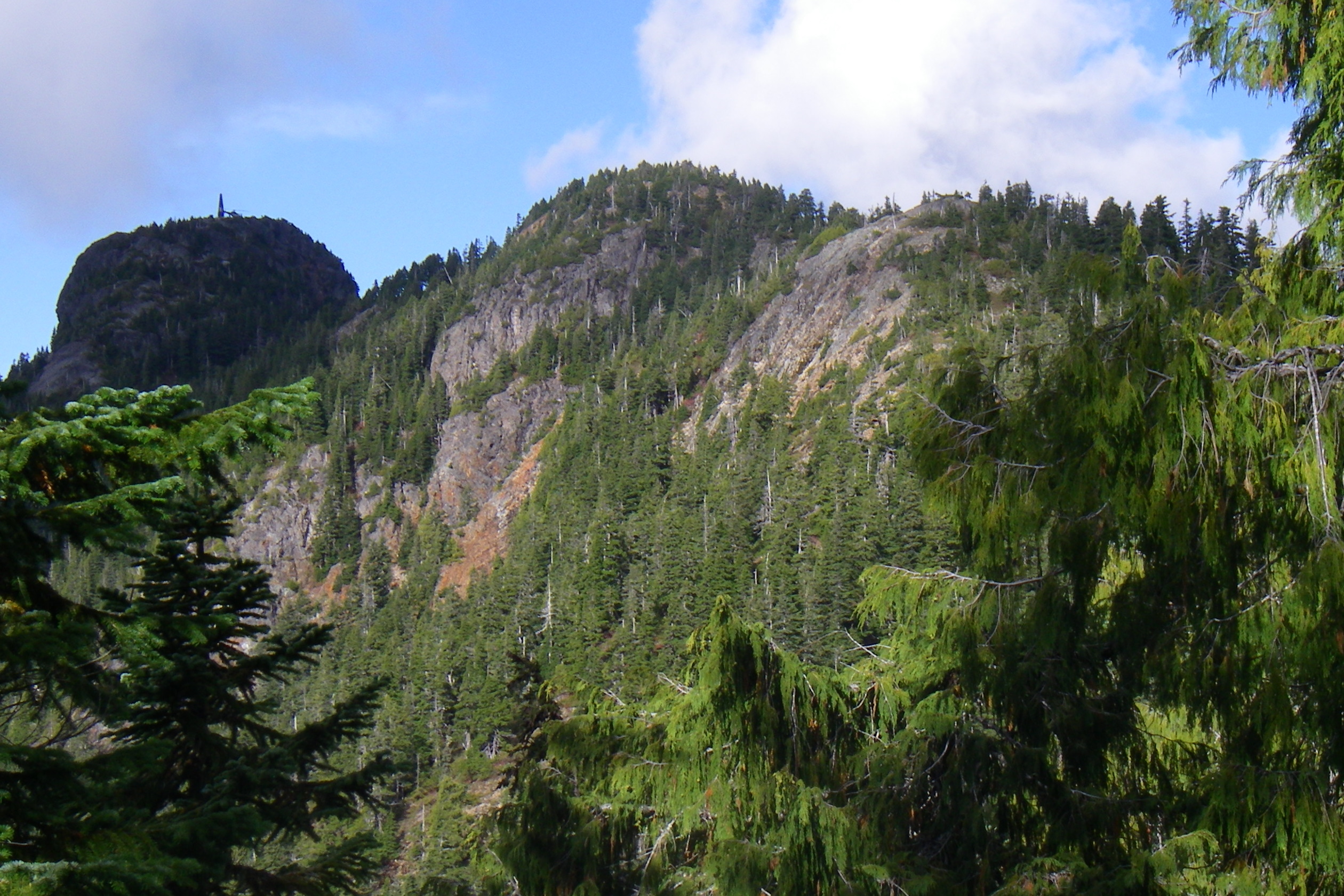
You pick up the Harvey Valley Trail at a marked junction just a few minutes prior to reaching the sturdy bridge that crosses over Harvey Creek on your way up the Binkert Trail. It’s a continuation of the logging road that peters out on its way up to the Harvey Pass area. On that very good North Shore Trail Map that came out a year or so ago, there is the following note about this trail: “completely brushed out in 2011; do not attempt until route is cleared”. So with low expectations going in, I ended up being pleasantly surprised. You will not get lost – the trail is very well flagged. You will have access to water from arms of Harvey Creek that intersect the trail a couple of times. The trail will be less than single track with bush up to your waist, but if you liked running through a corn maze as a kid you would like this. On a wet day it would feel like getting slapped with soggy noodles for an hour, but on a dry day shorts and short-sleeved shirt was fine. You do gain elevation but it’s over enough distance that it felt gradual and was runnable often once I realized route-finding wouldn’t be an issue. In fact, I think if you’re in Harvey Pass one day and want to get back to Lions Bay quickly, you’d make faster time taking this route back than going up and over Mt. Harvey or continuing on to descend the Brunswick Trail. And best of all, rather than being stuck in the forest the entire way, about halfway in you clear out into wide open spaces that you follow the rest of the way to the junction with the HSCT, with great views looking up at Harvey, the Lions, James, David, etc. Here's a pic of the Mt. Harvey ridge from the trail.
At the junction with the HSCT, turning left will send you to Magnesia Meadows and turning right will have you at the base of David Peak within a few hundred metres. So I went up and over David (had to briefly backtrack to the shortcut turnoff to David as I inadvertently found myself headed down and around David on the official HSCT route), continued up and over James, through the boulder field, spotted Enchantment Peak which will be one the agenda some day next year, paused at an injured but stabilized hiker who hurt himself near that ledge getting around the lower part of the West Lion and who was waiting with a couple of buddies for search and rescue, ate a sandwich among the hordes of people at the base of the West Lion (including a group that was yelling across in German to a friend who had decided to go for the summit but who was frozen in confusion/mild panic halfway up), and then made my way down the Binkert Trail. Here's a pic coming off of James Peak heading south.
So another fine season of bagging winds up. Thanks to David for organizing again and thanks to everyone who has entertained and informed with their tips and comments on peaks they have bagged – often your posts led me to new peaks and came in handy when I got there.
Never been to sleeping Beauty, and a sunny, snow-free late October Sunday has made my decision easy.
Started up BCMC at 7 am in total darkness, and crested towards the Chalet with a large orange fireball rising to my right, a full moon on my left, and a sea of clouds down behind me completely covering the lower mainland. And the smell of bacon oozing from the Chalet.
First target was Crown proper. The sun was shining brightly, it was unusually warm, the trail mostly dry, all this made for quick bagging. Sitting on Crown's narrow ledge peak with clouds below me and endless mountains surrounding me, in complete silence, I truly felt on top of the world. West Crown was now on my cross hairs.
5 minutes down and crossing the short scree field, I easily found the unmarked turn and route to Sleeping Beauty on my right, thanks to accurate beta from Bill. The narrow route starts ~40 meters south of the scree, and there's a small cairn on the opposite side of the main trail. The route is narrow but nicely flagged, and I've added a few more flagging on my way up to its marvelous peak.
After scaring off a big bruin, I was now back on the main Crown trail, down to Crown pass, and slogging back up to the Goat Mt. junction. It was still early, the weather was great, so why not continue the fun? Goat proper was bagged, then Little Billy and Dam along the ridge trail. Coming down Dam I unintentionally found the Beck trail-head, and for a few seconds contemplated going down it - alas, enough watershed trails for one day.
After bagging Grouse from its northern backside, I ran down to the now busy Chalet, and down BCMC again, to be back at the car - and the grey gloomy fog - after 5.5 hours of bliss.
Baggermeister: CRO, WCR, GOA, LIL, DAM, and GRO please.
Submitted by David Crerar on 19 October, 2013 - 21:21.
Joining fellow Team Dodgy member Dr. Neil Ambrose as a Bagger Challenge compleatist are Dave Berg and Carolyn King, owner of the Women's Quaich for the entire run of the Bagger Challenge,with their summitting of Mt Dickens in the spectacular sun while the rest of you were socked in by fogged down below and far south. Congratulations!
Submitted by neil ambrose on 22 October, 2013 - 21:09.
Wow, we did it!! Now that was a lot of early (very early) mornings and long days into the night. Thank-you David and Julia for all your efforts organizing the challenge. You always graciously replied to our crazy summit and finishing pics each journey.
It feels great to be done... I feel complete! I'm sure the remaining soldiers of team Dodgy will be out there again next year!
Cheers,
Carolyn
Submitted by Bill Dagg on 17 October, 2013 - 20:30.
Took the afternoon off work (because I deserve it) to get one last bag in before the end of the season. I've been eyeballing West Crown for awhile having not previously bagged it and felt from previous visits to Crown that I had a pretty good idea on how to get there. The weather was perfect and, not surprisingly (mid-October; mid-week), there were very few others on the trails (I counted 5 on the Crown route -- one of whom I knew -- and 2 coming back from Goat).
Not having a ton of time and not knowing how long it would take for the return trip, I took the old Gondola up to the Chalet and headed off just before 2 pm (~1 hr later than my intended start). For the most part, the route from Grouse is still in pretty good shape, the worst part being the descent into Crown Pass from Goat and a bit near the bottom of the ascent up to Crown -- quite damp and slippery. All snow from earlier in the month is now gone. I managed to get through without incident and arrived at what I presumed to be the junction to West Crown in approximately 1:20.
The trail to West Crown heads off to the left just before the scree field at the base of Crown. I noticed on the return that there's actually a little rock cairn at the junction on opposite side of the main trail to Crown. The trail is very faint and overgrown for the first 200 m or so but after that is pretty-well flagged. Jess had informed me that it takes about 30 minutes from the junction to the top of West Crown based on information she'd found. It took 28 minutes on a sometimes runnable trail that passes beside a nice little lake that I've seen from the top of Crown, then takes a relatively steep but short drop with a rope into the col at the base of West Crown. With the ribbons, it was pretty easy to find my way up to the peak, part of the time on a somewhat slippery (due to wet moss) sloping rock face. There was very little particularly exposed at this point so a fall would have probably just meant getting scraped and banged up a little.
In just under 2 hours, I reached the peak of West Crown and soaked up the spectacular evening views that included a partially fog-covered city well below.
I hung around on the peak for a bit, had some snacks, and then headed back to the Chalet. Other than wasting 5 minutes or so trying to find the route off of the peak, the return trip was uneventful.
Submitted by Spencer Sheinin on 16 October, 2013 - 16:00.
Having set a goal of 20 bags for my first official bagging year, I saved a couple easier ones for last. I worked my way up to 18 bags before running my first 100 miler in August. Not surprisingly, my interest in bagging waned during my taper and completely disappeared during recovery.
Knocking off Suicide Bluffs a couple weeks ago, I did a solo weekend bag of de Pencier bluffs to cap off the season. I assumed that it would be easy to find given the lack of detailed route descriptions available aside from a couple remarks of “good hike for the kids”. After all, how hard can, “find Mystery Lake and turn right” be?
After an easy and short hike to Mystery Lake, I turned right and followed a somewhat faint, but obvious trail and hit the bottom of Brockton Chair. Hmmm, I don’t remember mention of Brockton Chair in Bill Dagg’s diaper bag description (Bill talked about getting turned around in the fog and hitting mystery chair a couple times, but nothing about Brockton…and it was a perfectly clear day for me). Deciding to follow the basic mantra of “when in doubt, go up”, I hiked to the top of Brockton Chair, followed another faint path and struck gold on a clearly defined, well-marked trail…until I realized I was on the main Seymour trail. Finding a good lookout point, I spied my destination and retreated down one of the faint trails I ascended. The next six or seven trails I attempted to follow petered out into nothing, or brought me back towards the Seymour main trail.
Out of frustration and unwillingness to get stuck at 19 bags, I started heading back to Mystery Lake to look for a different "right turn". Descending past the bottom of Brocton chair and pretty close to the lake, I spotted a small shred of orange ribbon tied to a fallen branch about 50 meters off the trail. That little flag brought me to another faint, but decent trail up to my goal. Success! Good views on a bluebird day and my 20th bag of the season!
Moral of the story, if you hit Brockton Chair en route to de Pencier bluffs, you’ve gone too far.
Please put me down for DEP and SUI. Side note: I am noted as having bagged LYN, when it should actually be SLY. Thanks for a great bagging season!
Submitted by kmoeller on 15 October, 2013 - 15:18.
Mark me down for LYN and SLY, please.
I didn't realize SLY was just a tiny clearing in the middle of the trees but I actually wasn't too disappointed with the lack of a view. It was a gorgeous day so everyone and their dog (quite literally) was out and South Lynn summit was pretty much the only spot up there where I could take a quiet little break for snacks all by myself before carrying on. I wanted to bag at least one of the needles on this outing but after a later than planned start, found myself dubious that I'd make it back in time for a Monday thanksgiving dinner and so elected to turn back partway. Next time. On the way back down, some guy asked me if I knew where Sully's Hangout was. I had no idea what he was talking about and later looking it up, found out it's a rock climbing spot. You learn something new every day.
Submitted by reaganwhite on 14 October, 2013 - 19:47.
Bagged Black today with sons Carter and Isaac. Was so nice out today. Found half of a rusted ski pole and thought of Jackson, who probably could have tracked down the owner.
Ean and I bagged DePencier today. After a summer of road running and little trails due to a knee injury this was my first bag of the season - and likely the last. No I can join in the Bagger Banquet fun without feeling guilty.
It was a perfect day to be out in the mountains. Steel blue sky, nice temperatures, hummingbirds tweeting about, a few crows cawing and not many folks on the trail to easy, yet obscure little DePencier. The challenge was enough for my knee(s). We took just under an hour up and about the same back down - with a little non-bushwhacking bushwhacking thrown in by Jackson. Read, he thinks we were on the trail - I didn't. I felt cliffed out and turned around to find the real trail, Ean happily carried on ;-) Just a normal day at the T/J's.
Disappointing mushroom haul. All that we would have dared to eat were rotting after suffering through some night frost...Next time!
Submitted by reaganwhite on 14 October, 2013 - 19:51.
Hahah, that was Eric R and me last weekend. Fully bushwhacked up and down the knoll next to DEP and then found the trail further down and figured it out. I've bagged that peak a few times and have yet to do it efficiently.
Submitted by Ean Jackson on 13 October, 2013 - 18:33.
Turkey Day Monday is supposed to be perfecet blue skies and warm. 'Thinking of driving up to Seymour around 11-12:00 and bagging DePencer Bluffs and pick up a few mushrooms for dindin.
Kid friendly. Bring a basket to put your 'shrooms in.
Carnivorous, vegetarian, and vegan options will be served, along with the traditional themed cake. Please do not eat our pet guinea pigs. If you like, a side dish, a salad, or a dessert, or drinks, would be welcome.
Kilts and bagpipes permitted and even welcomed.
We will stream our traditional slideshow of Bagger adventures. Please please please post your photos on flickr. Add to the CFA Flickr Pool (instructions here. It's easy with the new Flickr interface). Tag your photos: ClubFatAss ClubFatAssEvents ClubFatAssEvents2013 BaggerChallenge2013 BaggerChallenge (with a space separating each tag on the flickr template)
Did both FRO and HOL for the first time last week. Wasn't expecting to see so much snow on hollyburn! I got this shot when I was catching the beautiful sunset at the top.
My big plan for yesterday was to go out and bag Crown. Little did I know that all that rain we were getting down here had translated into snow up there. Didn't get to my objective but I had fun in the white stuff and went up Little Goat and Dam even though I'd already laid claim to them earlier in the season. Here's a picture I took above Crown Pass...
Sunday's inversion and forecasted afternoon lightning storm called for a morning of a relatively safe Mt. Fromme loop.
Started at the top of Skyline drive, and used Dreamweaver to ford Mosquito creek, admire numerous old growth of Cedar and Fir, and regain the old Mtn Hwy. Brushing through the flat Hwy to ford the creek again, up Iroc and connect to the regular Mtn Hwy.
Slog up the steep Mt. Fromme trail to the south summit, touch - and seek closure for - a too-well known summit marker.
A quick down and up to the prettier north summit (Senate peak) with magnificent views north.
Time to get off the mountain but not for long - down to pipeline pass then slog up Erik the Red to Thunderbird ridge with pretty views of Kennedy lake and Goat ridge.
From the ridge it's a quick traverse back to Grouse alpine trail and the chalet zoo.
Down Simic's and Skyline/Jetboy to leave the sunny skies and re-enter a clouded, foggy reality.
I bagged Grouse, Dam, & Little Goat on Sunday. Hiked up BCMC, ran up the road to Grouse, went out and back on the Ridge trail to Little Goat, and then ran back down BCMC.
Submitted by mkuiack on 15 September, 2013 - 15:47.
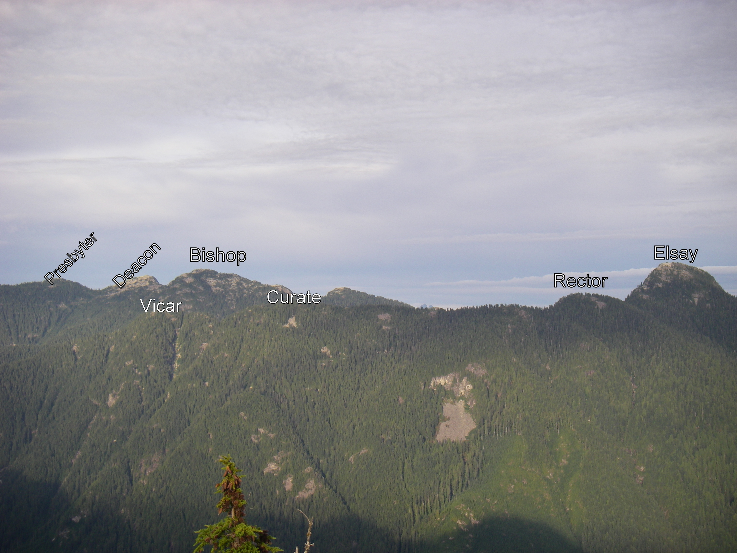
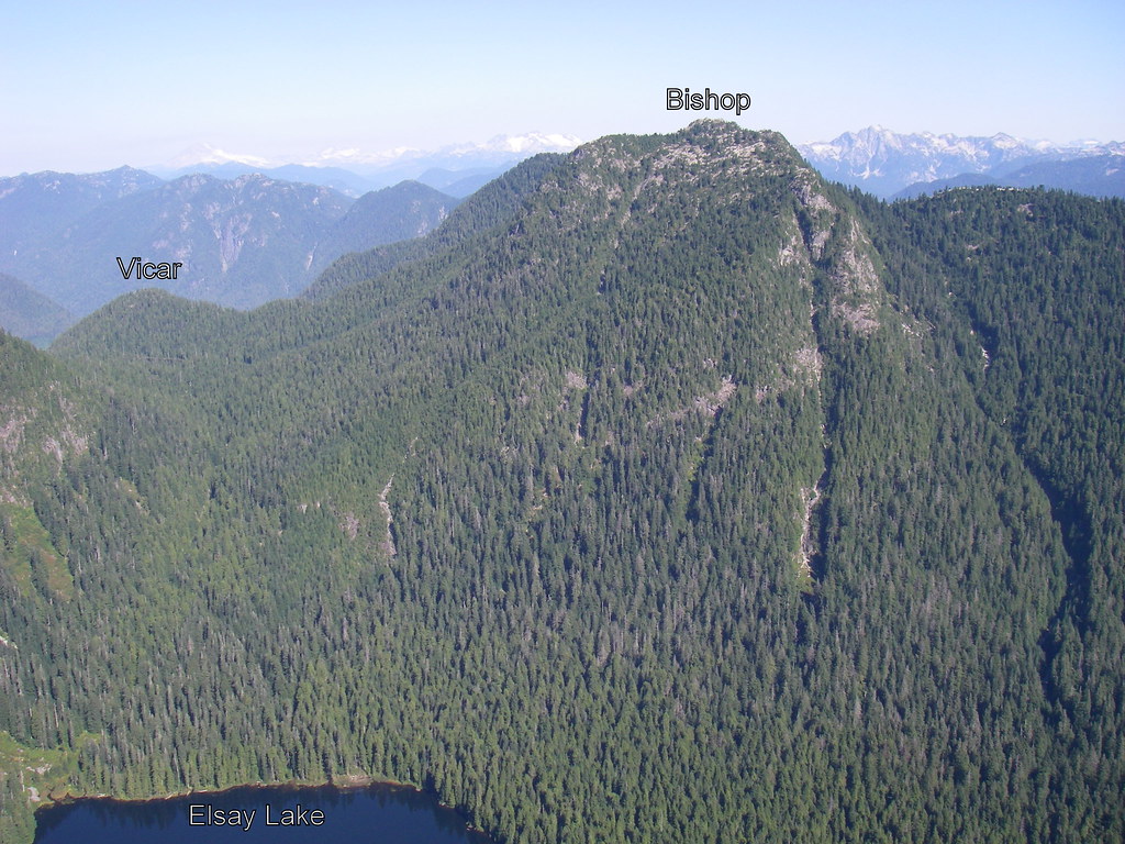
Long day on Saturday. Started and ended in overcast conditions at LSCR. In between, was sunshine most of the way once you hit the trailhead to Vicar Lakes and Mt. Bishop just past the Hatchery via Bear Island Bridge(s).
- a bike would have helped. 13km runs (first 10km on paved Seymour Trailway, final 3km to trailhead on gentle trail) at the beginning and end of the trail sections left me gassed
- as others have mentioned, the trail from the trailhead to Vicar Lakes, especially the first half, is steep and rugged with approximately 15 rope sections. On the way up, I only used a few of the ropes (trail was relatively dry) but they sure came in handy on the descent
- went for a short dip in the second and larger of the Vicar Lakes. Perfect temperature- cool enough to be refreshing but much warmer than the ocean
- trail from Vicar Lakes to the alpine is in the forest but not as intense as the lower trail, so is quite runnable in most parts on the way down
- great views in all directions from Mt. Bishop - north to Deacon Peak and beyond, west to Cathedral etc (with Vicar Lakes below), south towards the Elsay area
- mushrooms the sizes of small pizzas were everywhere; huckleberries and blueberries (not as tasty as the ones near Harvey Pass) were comon as well
- didn't do Deacon or Presbetyr, although Deacon is right there from the open area in the alpine and doesn't look like it would be much time as a sidetrip
Looking west from atop Mt. Bishop. Vicar Lakes down below, Cathedral across
Submitted by mkuiack on 11 September, 2013 - 18:24.
Prime bagging season now so I'm hoping to get some good outings in this month. Here are a few destinations at the top of my list
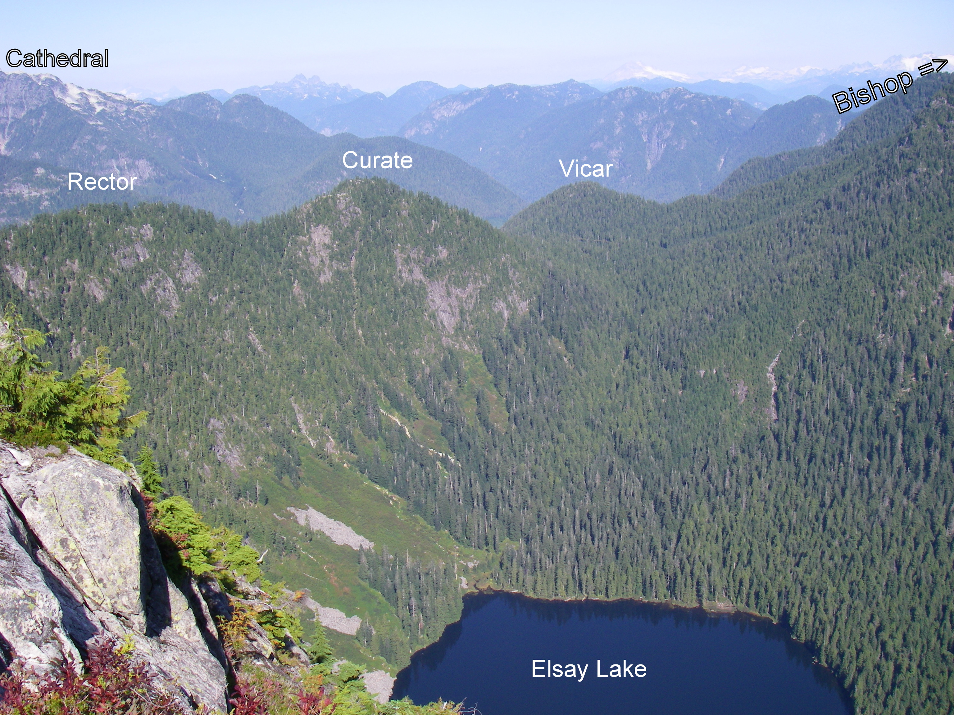
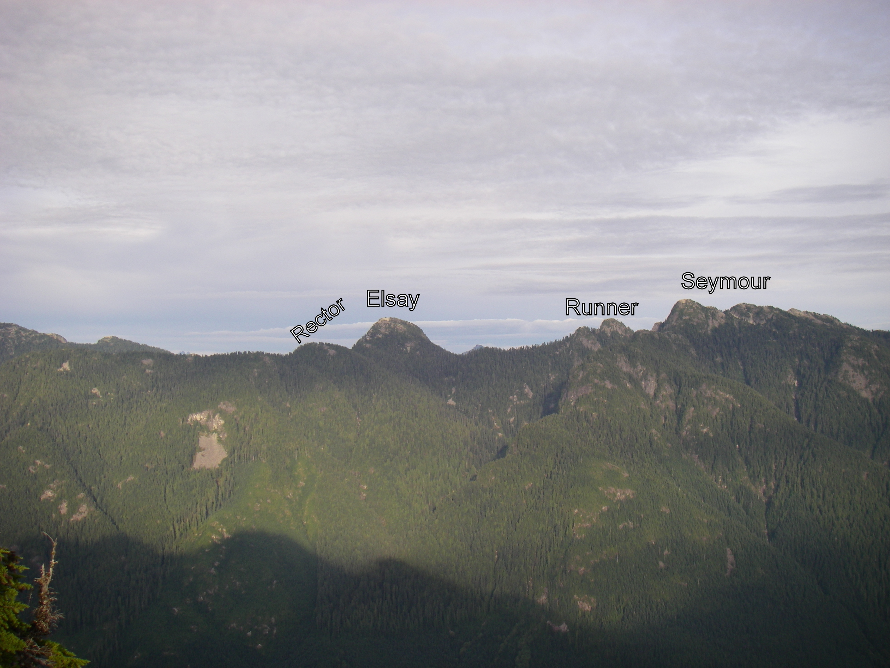
1. Mt Elsay- potentially Rector and/or Runners as well
2. David and James and Enchantment - could be done as a loop from Lions Bay or more interestingly, if took 2 cars, could be from Porteau Cove to either Lion's Bay or Cypress
3. Bishop - potentially Deacon as well. I don't have a bike so I'd need to get a 1 hour head start on you to run to the trailhead from the LSCR gazebo site .
Somewhere on one of the islands is another option, especially in early October if it starts snowing elsewhere,
If any of these sound interesting to you, am always interested in having company. I'm pretty flexible on the order. Typically like to get going by 7-7:30am since my family is sleeping then anyways,, but I would try to be flexible. And Sarurday is usually the day that works out on my end, but if the weather forecast looks iffy for a Saturday I sometimes am able to shuffle things to go Sunday or even Friday. Pace is not a concern - we can find one that suits. I cant promise that we'll get lost but I often do!
I've been to Bishop, but the trail is so fun that I'd be interested in doing it again and getting Deacon and Presbyter too. Unfortunately, I'm busy on Saturday mornings this month. I'm free on Sundays.
Submitted by Sibylle on 9 September, 2013 - 17:50.
From Julia (David's wife).
David is away adventuring and probably will not be able to respond to emails or update stats until Friday, September 20. Please go ahead and continue to submit as you normally would, but don't panic if you don't see the standings change right away. And as always, please check your own list for any errors and omissions. Thanks everyone and happy bagging!
I bagged Strachan and St. Mark's on Saturday afternoon. I started from the Cypress lot. I went up the Strachan trail to its peaks, then down the gulley on the trail next to Montizambert Creek to the HSCT. From there it's just out and back to St. Mark's. If anyone is missing a knife, I found one at the viewpoint near St. Mark's summit.
Submitted by Ean Jackson on 9 September, 2013 - 08:23.
Sunday 8 September was the 10th annual Mountain Highway Madness... a 15K run up and down Mountain Highway in North Vancouver. Some folks do the 15K loop several times.
Given that Mount Fromme (FRO) is not that far from the MHM turnaround, I thought I'd do a custom version of the event and bag a peak while I was at it. It took surprisingly little arm-twisting to convince most of the field to join me.
It was a mob scene at the peak. To my knowledge, it was the largest number of bagger to simultaneously bag a peak in the Bagger Challenge. Many enthusiastic newbie baggers where part of the mob.
Some notes:
Eric thought the run was on Saturday, so he missed the group photo by a day
I was not successful convincing my fellow baggers to help with my rock wall project by carrying a football-sized rock with them on the return leg
we found three (3) different types of boletes and some massive purple corts (mushrooms)
Frank arrived in Canada from South Africa a couple weeks ago. FRO was his baptism under fire
Submitted by mkuiack on 5 September, 2013 - 21:11.
Brilliant weather this past Saturday on Labour Day weekend. I knew it would be a fantastic day to spend some time on and around the Howe Sound Crest Trail. It was even a wee bit nippy near sea level at Lion’s Bay for my 8am start but it would warm up soon enough.
Had to park at the school back down the road from the Lion’s Bay trailhead. 7:00-7:15am seems to be the dividing line on summer weekend days for being able to secure one of the few parking spots at the trailhead. But while I used to hustle to try to get one, it’s really not that big of a deal if you miss out, as it was only a 7 minute light uphill jog from the school to the trailhead and faster coming back down at the end of the day.
Up the logging road until the well-marked colorful sign for the Brunswick Trail which veers to the left. It was no surprise that I encountered only 2 humans and 1 dog between hitting the trail turnoff and returning to the logging road via the Harvey Trail several hours later, but what was a pleasant surprise is that I encountered only a few more bugs than that.
The short flat stretch from the turnoff to Magnesia Creek is usually a great early chance to get the legs moving, but on this day there were at least half a dozen places where thin logs were across the trail. Too many to be coincidental it would seem. But while most were too high to hurdle over on the fly yet too low to limbo under, you simple had to slow down for a bit for easy stepovers. Magnesia Creek was easy to walk over with only a splash or two on your shoes, and after deliberately dunking my head into the creek it was onto the climb upwards, starting with a narrow fire road before the single track began.
One of the things I like about the Brunswick Trail is that because the steep final grunt up to Brunswick Mountain begins AFTER you pass the intersection with the HSCT, you can actually get up to the HSCT without too taxing of an effort, although you do need to gain a lot of elevation from Lion’s Bay. At the Brunswick Trail-HSCT junction at N 49.48592 W 123.20550 I headed left (north) towards Hat Pass where I would connect to the trail to my first two destinations – Fat Ass Peak and Hat Mountain. Last year when I bagged Brunswick Mountain and had my eye on bagging Fat Ass and Hat on a foggy day I missed the Hat Mountain turnoff from the HSCT and before I knew it had sailed down to Brunswick Lake. But with better tips and research as to where is the trailhead and with a more careful eye on a clearer day, I was able to find the flagging this time with no difficulty at N 49.49007 W 123.20439 , merely 5-10 minutes after leaving the Brunswick Trail. There was a patch of water to the right, the trail headed to the left.
While not the entire route from the HSCT to Fat Ass and Hat and back was runnable, much of it was and all of it was easy to follow. When atop Fat Ass Peak looking ahead to Hat, I first exited the summit to the right but quickly realized there were cliffs there and that instead exiting to the left was the correct way. Soon I reached the peak of Hat Mountain and its distinctive giant green phallic object. Great views of Howe Sound to the west, Brunswick to the south, and Hanover among others to the east.
Back to the HSCT and headed south and wanting to bag at least one more peak, I had a choice between Brunswick or two peaks close to Magnesia Meadows – David or Harvey. I selected Harvey, as climbing it from the northeast and then following its ridge to the Harvey Trail and back to Lion’s Bay would make for a nice loop. The turnoff from the HSCT to Mt. Harvey at N 49.47583 W 123.19355 led to my slowest stretch of the day – at least 15 minutes to go 100m. Not because of any trail difficulty, but because of the abundance of blueberries. Once I started eating one it was hard to stop and I had to drag myself away from them after a quarter of hour – I can certainly vouch for what Eric was saying about the quality of the berries!
The trail up Mt. Harvey from Harvey Pass is steep but without much exposure or cause for any nervousness (at least not uphill – I could see one 5-minute stretch being more uncomfortable going down for average baggers like me if a wet day). Well-marked and gets you to the peak quickly. Great views of The Lions from this peak and then a nice largely-runnable ridge route before you say goodbye to The Lions at a clearing and head down into the forest onto the Harvey Trail and then onto the logging road back to Lion’s Bay.
Great day on the trails. I was out there for around 7 ½ hours, but that included a good 1 hour if not more of stops for pics and breaks, and hustling could shave more time off that if one were facing time constraints. September is my favorite bagging month, so I look forward to what the coming weekends have in store.
Submitted by teagirl on 5 September, 2013 - 06:33.
We had family plans to bag a peak on Labour Day which weren't dampened by waking up to rain rain rain. Although we did think twice when there started being thunder & lightning - peak-bagging with a metal backpack containing a child, during an electric storm?? Possibly not a great parenting choice... Luckily when diaper-bagging, getting ready usually takes forever so by the time we were ready to go the weather had changed :) Although the poor weather did convince to do a peak we had done before, rather than attempting De Pencier bluffs. I want to try it someday soon, but reading the Daggs experience of argh-this-still-isn't-the-right-trail didn't sound like something we (mostly the husband, who is generally more sensible than I!) wanted to do on a rainy day with our getting-heavier-by-the-day kid :)
So we headed up Lynn Peak. We share the load, Brendan likes the aluminum-framed Deuter Kid Comfort III (thanks Daggs for recommending it - we found one on Craigslist practically brand-new!); but I prefer our soft backpack (Lillebaby Everywear, for those who care). It's hilarious though: when I'm wearing her, you basically can't see her from the front, so we get these odd puzzled looks when she's making her yelly squeaky baby noises but all people can see is two adults! We also get a lot of double takes or shrieks of laughter when we've passed someone.
Got up in just under 2h, then backtracked to the viewpoint to eat some snacks (and *not* share with the super-aggressive chipmunk!).
We met a forest service ranger & mentioned a lot of blow-down on the trail to SLY and he was like, "Oh, you're not supposed to be on that trail! It's not on the map". Whatever. It's on my map, which is obviously better than his map :) [no, I get it, it's decommissioned and they don't want the General Public going up there. Which is unfortunate 'cause that part of the trail is basically the prettiest bit! Although SLY itself is really nothing to write home about and we didn't think it was prudent to go any further]
So there you have it. Our first diaper bag of the year. Hopefully the weather stays nice-ish and we can hit a few more, I have great memories of the gorgeous fall foliage last October when peak-bagging! Although diaper bagging with a 6-week-old is in some ways much easier than diaper bagging with a one-and-a-little-bit-year-old...
Thanks for hosting this Challenge which gets us out to do stuff in places we probably wouldn't otherwise bother to go, on days we otherwise might not go out!
Submitted by David Crerar on 3 September, 2013 - 20:44.
Elevation: 1408m
Soundbite: a steep climb leading to an unique view of the Camel and the Hanes Valley
Caution: Remote. No flagged trails. Steep sides.
Round trip distance: 30K from Lynn Headwaters Park
Prominence: 158m
Bang for buck: 3/5
Difficulty: 4.5/5
Snow free: from late July
Peakview: 4/5
Must-sees en route: blueberries. If from east: zinc mine remnants, old growth trees.
Scenery: 3/5
Kids: not suitable
Dogs: not suitable
Runnability: 1/5
Terrain: largely bushwhacking (from west) or scrambling (from south)
True peak location: westmost bump
Access: from Lynn Headwaters or via Grouse Mountain
Public transit: 208/209 bus to Lynn Headwaters
Cell coverage: spotty
Sun: mostly exposed for peak approach. Hanes Valley and Grouse Mountain trails mostly covered
Water: ample water from Hanes Valley approach. Little from Grouse Mountain approach. No drinkable water on ridge.
Route links: could link with Perrault.
Name origin: "Sleeping Beauty" theme: written by Perrault. Named by Robin Tivy of Bivouac.com
Name status: unofficial, from circa. 2013
First ascent: unknown
Headwaters: tributaries of Capilano River and Hanes Creek
Best views from: Hanes Valley, Crown Mountain
Other write-ups: useful online and paper sources: none
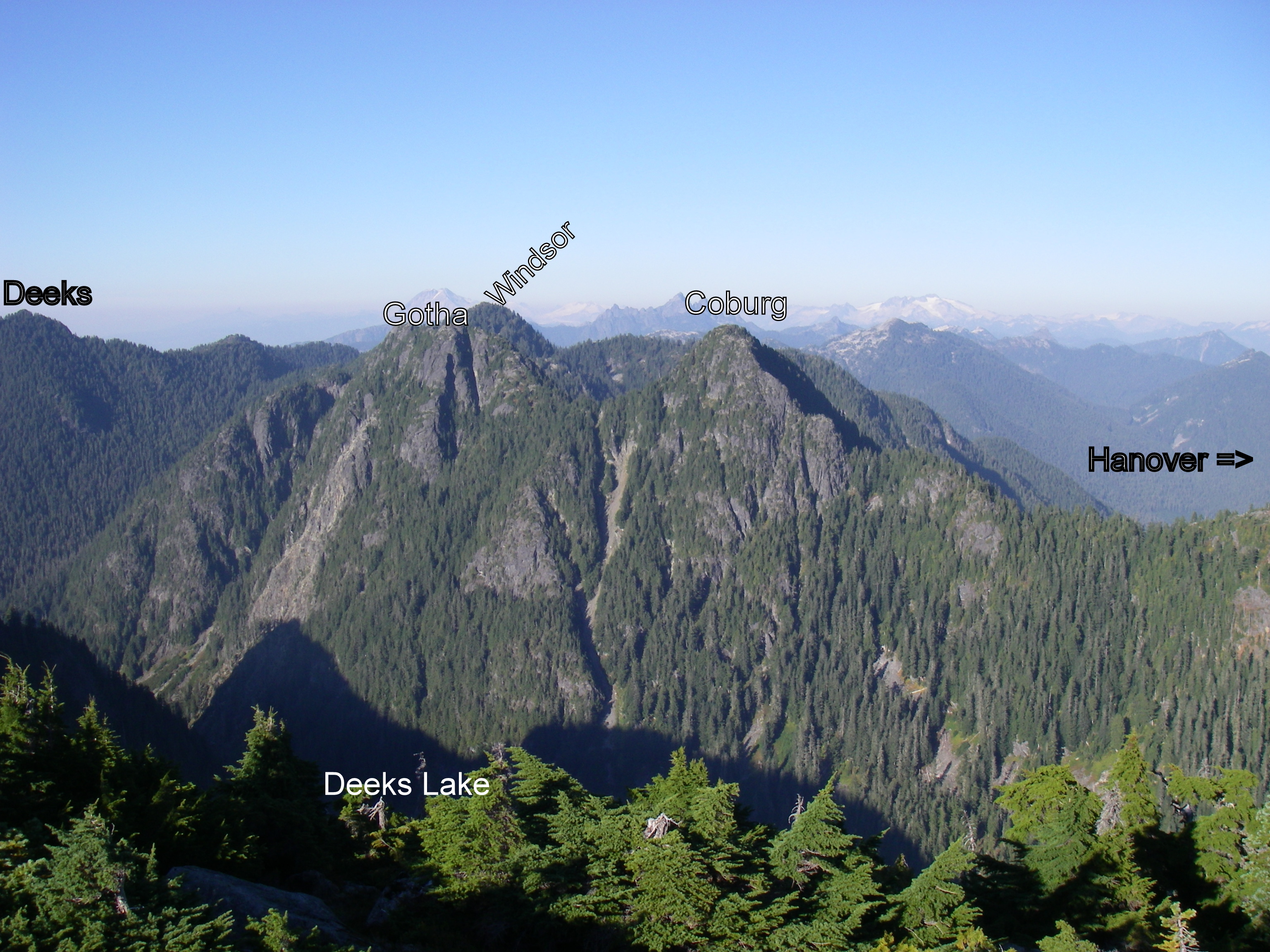
Crown N1/Godmother is the newest Bagger Challenge Peak. It is the west-most and highest peak on the west-east ridge running from Crown to Burwell (although not accessible from either of those peaks absent ropes). Its two names were both bestowed upon it by Robin Tivy, an experienced mountaineer whose Bivouac.com provides a great service to local adventurers, and which should be an annual subscription for anyone reading this. Although a bit twee and Disneyfied, the new name of Godmother Peak is presented as consistent with the "Sleeping Beauty" theme ("Sleeping Beauty" being a legitimate older name for West Crown Peak), whence the names for Spindle (the shorted but pointier peak between CN1 and Crown) and (Charles) Perrault peak are also derived.
There are two approaches: from the south, starting at the east (bottom) end of the Hanes Valley boulder field or from the east, along the Perrault ridge, attained via a bushwhack from its east end and through a 1950s zinc mining camp. Both lead to a final peak assault that pushes comfort levels.
The best trip report is that of Old Matt, posted on ClubTread. His photograph of his route from the east ridge (left) matches the one that we thrashed out, going down, almost exactly. It looks scary, but at no time was it terrifying or excessively exposed. Caution is very necessary.
Our ascent route is marked below in dark purple (the pinkish purple is an earlier ascent and descent of Perrault). There were several false starts. We ascended too high up the Hanes Valley Trail boulder field, anticipating an easy traverse NE. In fact, this route took us to and through a nasty copse of alders and devils club: not recommended. And then a snow field. And a descent and a climb.
The better route (albeit a hypothetical one) is marked by a thin lavender line. From near the base of the boulder field, drive NW straight towards a rockslide/creek below the peak. Apart from some minor bushwhacking, it should be a boulder scramble up to a creek. Then a few careful hand-climbs up a few short rock faces. If in doubt, veer right. This will lead to a balcony in front of a near-cliff on south face of CN1. At this point, veer right again, into shrubbery. And then out onto a long rock slab resembling those on the ascent of Crown. Up and around to the base of the peak itself. The peak proper is claimed from the right/east, up to a false summit, and then as far west as you can.
This was roughly the route of the intrepid Dave Berg, the first Bagger Challenge guinea pig for Crown N1.
On the peak, magnificent views of the back-side of The Camel and Crown, along with the Howe Sound Crest Trail peaks, the watershed road, Capilano Lake, Sky Pilot, the Garibaldi Peaks, and the entire Hanes Valley will greet you.
The approach from the east is safer, but still dicey, especially for the final ascent, as shown in Old Matt's photo above. Ascend the Perrault Ridge to the zinc mining camp, as set out in other reports. On the ridge, instead of heading NE to Perrault, head W. You'll climb up and down two minor peaks topped with tarns. Although there are steep spots, the route is generally sensible and doable. The best tip: DO NOT try to skip the peaks by traversing along the side: although the contour lines look appealling, both of our attempts to do so led to burly and bushy and steep exercises in pain and futility.
Bill, Neil and I were glad that we went, especially given the spectacular long-weekend sun. But it taxed our comfort levels, and it should not be attempted in less-than perfect conditions: those rocks would be a slippery death-trap.


Comments
Last of the season.
With mere hours left in the 2013 Bagger Challenge, I set out in an attempt to keep the Schmitz at bay. I'd heard that Marc was planning a trip to secure his twentieth piece of baggage for the season and my fragile ego couldn't take it. If he tied me, his starbags would propel him by me in the standings. I had to act fast.
Starting from the Cypress parking lot, I headed out on the Baden Powell (where I promptly fell on my face and scraped both knees) to the Mount Strachan Trail, past the plane crash and on to the North Peak of Mount Strachan. After a few minutes soaking up the views and feeding a couple Whiskeyjacks, I headed down to the Howe Sound Crest Trail by way of Christmas Gully and back to where I'd started. It was a bluebird day and a beauty way to wrap up the Bagging season.
Check your bags and totals!
.
PHOTOS !
At the Bagger Banquet, we'll do a glorious slide show of bagging adventures this year.
Please post your photos, too. Add to the CFA Flickr Pool (instructions here. It's easy!), tag your photos: ClubFatAss ClubFatAssEvents ClubFatAssEvents2013 BaggerChallenge2013 BaggerChallenge (with a space separating each tag on the flickr template)
David and James Via Harvey Valley Trail
My aims on Saturday were:
a) escape into the sunshine above fog-enveloped Vancouver
b) take a route up to the Howe Sound Crest Trail that I had not previously tried
c) snag a couple of peaks in my final bagging expedition of the season
Leaving the Lions Bay trailhead parking lot at 7:15am, I met objective a) by the time I got halfway up the logging road, as by then it was already late enough and high enough for the sun to be out. Beautiful day ahead.
As far as I know, there are 6 ways up to the HSCT from Lions Bay: i) the Binkert Trail; ii) the Brunswick trail; iii) the Harvey Trail; iv) the Unnecessary Trail that starts at a quieter trailhead a couple of kms away on the other side of the village; v) the Harvey Valley Trail (I’ve also seen it referred to as the Harvey Creek Trail or Harvey Creek Road; and vi) a trail that follows Magnesia Creek but ends on the north side of Mt. Harvey, requiring a bushwhack to the HSCT. If you count the Tunnel Bluffs-Hat Mountain trail, that would be #7. I have been up and down each of i) through iv) so thought I’d give v) a try.
You pick up the Harvey Valley Trail at a marked junction just a few minutes prior to reaching the sturdy bridge that crosses over Harvey Creek on your way up the Binkert Trail. It’s a continuation of the logging road that peters out on its way up to the Harvey Pass area. On that very good North Shore Trail Map that came out a year or so ago, there is the following note about this trail: “completely brushed out in 2011; do not attempt until route is cleared”. So with low expectations going in, I ended up being pleasantly surprised. You will not get lost – the trail is very well flagged. You will have access to water from arms of Harvey Creek that intersect the trail a couple of times. The trail will be less than single track with bush up to your waist, but if you liked running through a corn maze as a kid you would like this. On a wet day it would feel like getting slapped with soggy noodles for an hour, but on a dry day shorts and short-sleeved shirt was fine. You do gain elevation but it’s over enough distance that it felt gradual and was runnable often once I realized route-finding wouldn’t be an issue. In fact, I think if you’re in Harvey Pass one day and want to get back to Lions Bay quickly, you’d make faster time taking this route back than going up and over Mt. Harvey or continuing on to descend the Brunswick Trail. And best of all, rather than being stuck in the forest the entire way, about halfway in you clear out into wide open spaces that you follow the rest of the way to the junction with the HSCT, with great views looking up at Harvey, the Lions, James, David, etc. Here's a pic of the Mt. Harvey ridge from the trail.
At the junction with the HSCT, turning left will send you to Magnesia Meadows and turning right will have you at the base of David Peak within a few hundred metres. So I went up and over David (had to briefly backtrack to the shortcut turnoff to David as I inadvertently found myself headed down and around David on the official HSCT route), continued up and over James, through the boulder field, spotted Enchantment Peak which will be one the agenda some day next year, paused at an injured but stabilized hiker who hurt himself near that ledge getting around the lower part of the West Lion and who was waiting with a couple of buddies for search and rescue, ate a sandwich among the hordes of people at the base of the West Lion (including a group that was yelling across in German to a friend who had decided to go for the summit but who was frozen in confusion/mild panic halfway up), and then made my way down the Binkert Trail. Here's a pic coming off of James Peak heading south.
So another fine season of bagging winds up. Thanks to David for organizing again and thanks to everyone who has entertained and informed with their tips and comments on peaks they have bagged – often your posts led me to new peaks and came in handy when I got there.
Escape the Fog
With the kids in school and more and more accounts claiming that there is sun above the clouds, I had to see for myself.
So I used this sleepy foggy Monday morning to pay a visit to Seymour and De Pencier this morning.
It's so glorious up there right now. Sunny and warm.
View from De Pencier
Panorama on Seymour
Baggermeister: Sey and Dep please.
An October Crowning
Never been to sleeping Beauty, and a sunny, snow-free late October Sunday has made my decision easy.
Started up BCMC at 7 am in total darkness, and crested towards the Chalet with a large orange fireball rising to my right, a full moon on my left, and a sea of clouds down behind me completely covering the lower mainland. And the smell of bacon oozing from the Chalet.
First target was Crown proper. The sun was shining brightly, it was unusually warm, the trail mostly dry, all this made for quick bagging. Sitting on Crown's narrow ledge peak with clouds below me and endless mountains surrounding me, in complete silence, I truly felt on top of the world. West Crown was now on my cross hairs.
5 minutes down and crossing the short scree field, I easily found the unmarked turn and route to Sleeping Beauty on my right, thanks to accurate beta from Bill. The narrow route starts ~40 meters south of the scree, and there's a small cairn on the opposite side of the main trail. The route is narrow but nicely flagged, and I've added a few more flagging on my way up to its marvelous peak.
After scaring off a big bruin, I was now back on the main Crown trail, down to Crown pass, and slogging back up to the Goat Mt. junction. It was still early, the weather was great, so why not continue the fun? Goat proper was bagged, then Little Billy and Dam along the ridge trail. Coming down Dam I unintentionally found the Beck trail-head, and for a few seconds contemplated going down it - alas, enough watershed trails for one day.
After bagging Grouse from its northern backside, I ran down to the now busy Chalet, and down BCMC again, to be back at the car - and the grey gloomy fog - after 5.5 hours of bliss.
Baggermeister: CRO, WCR, GOA, LIL, DAM, and GRO please.
Berg and King, Compleatists
Joining fellow Team Dodgy member Dr. Neil Ambrose as a Bagger Challenge compleatist are Dave Berg and Carolyn King, owner of the Women's Quaich for the entire run of the Bagger Challenge, with their summitting of Mt Dickens in the spectacular sun while the rest of you were socked in by fogged down below and far south. Congratulations!
We Did It!!!
Late Season Bag of West Crown (WCR)
Took the afternoon off work (because I deserve it) to get one last bag in before the end of the season. I've been eyeballing West Crown for awhile having not previously bagged it and felt from previous visits to Crown that I had a pretty good idea on how to get there. The weather was perfect and, not surprisingly (mid-October; mid-week), there were very few others on the trails (I counted 5 on the Crown route -- one of whom I knew -- and 2 coming back from Goat).
Not having a ton of time and not knowing how long it would take for the return trip, I took the old Gondola up to the Chalet and headed off just before 2 pm (~1 hr later than my intended start). For the most part, the route from Grouse is still in pretty good shape, the worst part being the descent into Crown Pass from Goat and a bit near the bottom of the ascent up to Crown -- quite damp and slippery. All snow from earlier in the month is now gone. I managed to get through without incident and arrived at what I presumed to be the junction to West Crown in approximately 1:20.
The trail to West Crown heads off to the left just before the scree field at the base of Crown. I noticed on the return that there's actually a little rock cairn at the junction on opposite side of the main trail to Crown. The trail is very faint and overgrown for the first 200 m or so but after that is pretty-well flagged. Jess had informed me that it takes about 30 minutes from the junction to the top of West Crown based on information she'd found. It took 28 minutes on a sometimes runnable trail that passes beside a nice little lake that I've seen from the top of Crown, then takes a relatively steep but short drop with a rope into the col at the base of West Crown. With the ribbons, it was pretty easy to find my way up to the peak, part of the time on a somewhat slippery (due to wet moss) sloping rock face. There was very little particularly exposed at this point so a fall would have probably just meant getting scraped and banged up a little.
In just under 2 hours, I reached the peak of West Crown and soaked up the spectacular evening views that included a partially fog-covered city well below.
I hung around on the peak for a bit, had some snacks, and then headed back to the Chalet. Other than wasting 5 minutes or so trying to find the route off of the peak, the return trip was uneventful.
Total time (including stops and peak time): 3:50.
19th and 20th bags…
Having set a goal of 20 bags for my first official bagging year, I saved a couple easier ones for last. I worked my way up to 18 bags before running my first 100 miler in August. Not surprisingly, my interest in bagging waned during my taper and completely disappeared during recovery.
Knocking off Suicide Bluffs a couple weeks ago, I did a solo weekend bag of de Pencier bluffs to cap off the season. I assumed that it would be easy to find given the lack of detailed route descriptions available aside from a couple remarks of “good hike for the kids”. After all, how hard can, “find Mystery Lake and turn right” be?
After an easy and short hike to Mystery Lake, I turned right and followed a somewhat faint, but obvious trail and hit the bottom of Brockton Chair. Hmmm, I don’t remember mention of Brockton Chair in Bill Dagg’s diaper bag description (Bill talked about getting turned around in the fog and hitting mystery chair a couple times, but nothing about Brockton…and it was a perfectly clear day for me). Deciding to follow the basic mantra of “when in doubt, go up”, I hiked to the top of Brockton Chair, followed another faint path and struck gold on a clearly defined, well-marked trail…until I realized I was on the main Seymour trail. Finding a good lookout point, I spied my destination and retreated down one of the faint trails I ascended. The next six or seven trails I attempted to follow petered out into nothing, or brought me back towards the Seymour main trail.
Out of frustration and unwillingness to get stuck at 19 bags, I started heading back to Mystery Lake to look for a different "right turn". Descending past the bottom of Brocton chair and pretty close to the lake, I spotted a small shred of orange ribbon tied to a fallen branch about 50 meters off the trail. That little flag brought me to another faint, but decent trail up to my goal. Success! Good views on a bluebird day and my 20th bag of the season!
Moral of the story, if you hit Brockton Chair en route to de Pencier bluffs, you’ve gone too far.
Please put me down for DEP and SUI. Side note: I am noted as having bagged LYN, when it should actually be SLY. Thanks for a great bagging season!
LYN and SLY
Mark me down for LYN and SLY, please.
I didn't realize SLY was just a tiny clearing in the middle of the trees but I actually wasn't too disappointed with the lack of a view. It was a gorgeous day so everyone and their dog (quite literally) was out and South Lynn summit was pretty much the only spot up there where I could take a quiet little break for snacks all by myself before carrying on. I wanted to bag at least one of the needles on this outing but after a later than planned start, found myself dubious that I'd make it back in time for a Monday thanksgiving dinner and so elected to turn back partway. Next time. On the way back down, some guy asked me if I knew where Sully's Hangout was. I had no idea what he was talking about and later looking it up, found out it's a rock climbing spot. You learn something new every day.
Kid bag
Bagged Black today with sons Carter and Isaac. Was so nice out today. Found half of a rusted ski pole and thought of Jackson, who probably could have tracked down the owner.
Ean and I bagged DePencier
Ean and I bagged DePencier today. After a summer of road running and little trails due to a knee injury this was my first bag of the season - and likely the last. No I can join in the Bagger Banquet fun without feeling guilty.
It was a perfect day to be out in the mountains. Steel blue sky, nice temperatures, hummingbirds tweeting about, a few crows cawing and not many folks on the trail to easy, yet obscure little DePencier. The challenge was enough for my knee(s). We took just under an hour up and about the same back down - with a little non-bushwhacking bushwhacking thrown in by Jackson. Read, he thinks we were on the trail - I didn't. I felt cliffed out and turned around to find the real trail, Ean happily carried on ;-) Just a normal day at the T/J's.
Disappointing mushroom haul. All that we would have dared to eat were rotting after suffering through some night frost...Next time!
bushwacking on DEP
Hahah, that was Eric R and me last weekend. Fully bushwhacked up and down the knoll next to DEP and then found the trail further down and figured it out. I've bagged that peak a few times and have yet to do it efficiently.
Mushroom Bag, Anyone?
Turkey Day Monday is supposed to be perfecet blue skies and warm. 'Thinking of driving up to Seymour around 11-12:00 and bagging DePencer Bluffs and pick up a few mushrooms for dindin.
Kid friendly. Bring a basket to put your 'shrooms in.
RSVP here or give me a call at 604-904-6554
Busy weekend
I've been on a bit of a blitz before time runs out . . . did DEP and SUI on Friday, DAM and GOA on Saturday and then MAR and STR today.
Fine company at the top of Strachan this afternoon:
Freaky bird. Great photo!
Freaky bird. Great photo!
Fifth Annual Baggers' Banquet: Friday, October 25, 2013
All Baggers are cordially invited to attend the Fifth Annual Baggers' Banquet
The covetted Bagger Quaiches will be awarded. Immortality will be achieved. Tales will be told.

We will stream our traditional slideshow of Bagger adventures. Please please please post your photos on flickr. Add to the CFA Flickr Pool (instructions here. It's easy with the new Flickr interface). Tag your photos: ClubFatAss ClubFatAssEvents ClubFatAssEvents2013 BaggerChallenge2013 BaggerChallenge (with a space separating each tag on the flickr template)
Last two weeks
1. Mike Kuiack blasts into the top 10 with an epic summitting of BLA!
2. How is the snow? Did it melt off?
3. Check your bags and totals!
4. Be careful out there with the increasingly early sundowns! 6:29 tonight!
FRO and HOL
Did both FRO and HOL for the first time last week. Wasn't expecting to see so much snow on hollyburn! I got this shot when I was catching the beautiful sunset at the top.
No more snow: at least on top of Strachan
No more snow: at least on top of Strachan
Yep, I was actually surprised
Yep, I was actually surprised to see it was completely clear up there.
That's an incredible picture.
That's an incredible picture.
Thanks! I was surprised I was
Thanks! I was surprised I was able to get such a decent shot with a lower quality gopro.
Home stretch
As we embark on the final two weeks of bagging, double-check your lists and the math!
And be safe out there, with the snow and the early nights (lights out at 6:35pm).
One
Snow!
My big plan for yesterday was to go out and bag Crown. Little did I know that all that rain we were getting down here had translated into snow up there. Didn't get to my objective but I had fun in the white stuff and went up Little Goat and Dam even though I'd already laid claim to them earlier in the season. Here's a picture I took above Crown Pass...
YIKES!
and lots of it. Be cautious out there, baggers.
Earliest snowfall in the years of the Bagger Challenge.
A Fromme closure
Sunday's inversion and forecasted afternoon lightning storm called for a morning of a relatively safe Mt. Fromme loop.
Started at the top of Skyline drive, and used Dreamweaver to ford Mosquito creek, admire numerous old growth of Cedar and Fir, and regain the old Mtn Hwy. Brushing through the flat Hwy to ford the creek again, up Iroc and connect to the regular Mtn Hwy.
Slog up the steep Mt. Fromme trail to the south summit, touch - and seek closure for - a too-well known summit marker.
A quick down and up to the prettier north summit (Senate peak) with magnificent views north.
Time to get off the mountain but not for long - down to pipeline pass then slog up Erik the Red to Thunderbird ridge with pretty views of Kennedy lake and Goat ridge.
From the ridge it's a quick traverse back to Grouse alpine trail and the chalet zoo.
Down Simic's and Skyline/Jetboy to leave the sunny skies and re-enter a clouded, foggy reality.
Baggermeister: FRO with a personal star please.
Visited an old friend, Ran.
Visited an old friend, Ran. Lickily, the fog was far below you this time ;-)
Dr Neil Ambrose, Compleatist
Congratulations to Dr Neil Ambrose for his conquest of all of the peaks in the Bagger Challenge, with his bag of mighty Cathedral.
Congratulations, Neil!
Congratulations, Neil! Impressive.
To my all-time favourite Dr. Vet the Bagger
Sir you have compleated
With in your mind the pleated
Kilt of yore
You achieved it more
Than many have before.
Keep it Dodgy!
Very Dodgy Moore
Grouse, Dam, & Little Goat
I bagged Grouse, Dam, & Little Goat on Sunday. Hiked up BCMC, ran up the road to Grouse, went out and back on the Ridge trail to Little Goat, and then ran back down BCMC.
View from Grouse:
On top of Dam:
Rain on Little Goat
Bishop
Long day on Saturday. Started and ended in overcast conditions at LSCR. In between, was sunshine most of the way once you hit the trailhead to Vicar Lakes and Mt. Bishop just past the Hatchery via Bear Island Bridge(s).
- a bike would have helped. 13km runs (first 10km on paved Seymour Trailway, final 3km to trailhead on gentle trail) at the beginning and end of the trail sections left me gassed
- as others have mentioned, the trail from the trailhead to Vicar Lakes, especially the first half, is steep and rugged with approximately 15 rope sections. On the way up, I only used a few of the ropes (trail was relatively dry) but they sure came in handy on the descent
- went for a short dip in the second and larger of the Vicar Lakes. Perfect temperature- cool enough to be refreshing but much warmer than the ocean
- trail from Vicar Lakes to the alpine is in the forest but not as intense as the lower trail, so is quite runnable in most parts on the way down
- great views in all directions from Mt. Bishop - north to Deacon Peak and beyond, west to Cathedral etc (with Vicar Lakes below), south towards the Elsay area
- mushrooms the sizes of small pizzas were everywhere; huckleberries and blueberries (not as tasty as the ones near Harvey Pass) were comon as well
- didn't do Deacon or Presbetyr, although Deacon is right there from the open area in the alpine and doesn't look like it would be much time as a sidetrip
Looking west from atop Mt. Bishop. Vicar Lakes down below, Cathedral across
Looking north to Deacon Peak from atop Mt. Bishop
Baggage Wishlist
Prime bagging season now so I'm hoping to get some good outings in this month. Here are a few destinations at the top of my list
1. Mt Elsay- potentially Rector and/or Runners as well
2. David and James and Enchantment - could be done as a loop from Lions Bay or more interestingly, if took 2 cars, could be from Porteau Cove to either Lion's Bay or Cypress
3. Bishop - potentially Deacon as well. I don't have a bike so I'd need to get a 1 hour head start on you to run to the trailhead from the LSCR gazebo site .
Somewhere on one of the islands is another option, especially in early October if it starts snowing elsewhere,
If any of these sound interesting to you, am always interested in having company. I'm pretty flexible on the order. Typically like to get going by 7-7:30am since my family is sleeping then anyways,, but I would try to be flexible. And Sarurday is usually the day that works out on my end, but if the weather forecast looks iffy for a Saturday I sometimes am able to shuffle things to go Sunday or even Friday. Pace is not a concern - we can find one that suits. I cant promise that we'll get lost but I often do!
Drop me a line or post here if you'd like.
I've been to Bishop, but the
I've been to Bishop, but the trail is so fun that I'd be interested in doing it again and getting Deacon and Presbyter too. Unfortunately, I'm busy on Saturday mornings this month. I'm free on Sundays.
I'm also interested in any of the islands.
Bagger Meister and Point Keeper Away!
From Julia (David's wife).
David is away adventuring and probably will not be able to respond to emails or update stats until Friday, September 20. Please go ahead and continue to submit as you normally would, but don't panic if you don't see the standings change right away. And as always, please check your own list for any errors and omissions. Thanks everyone and happy bagging!
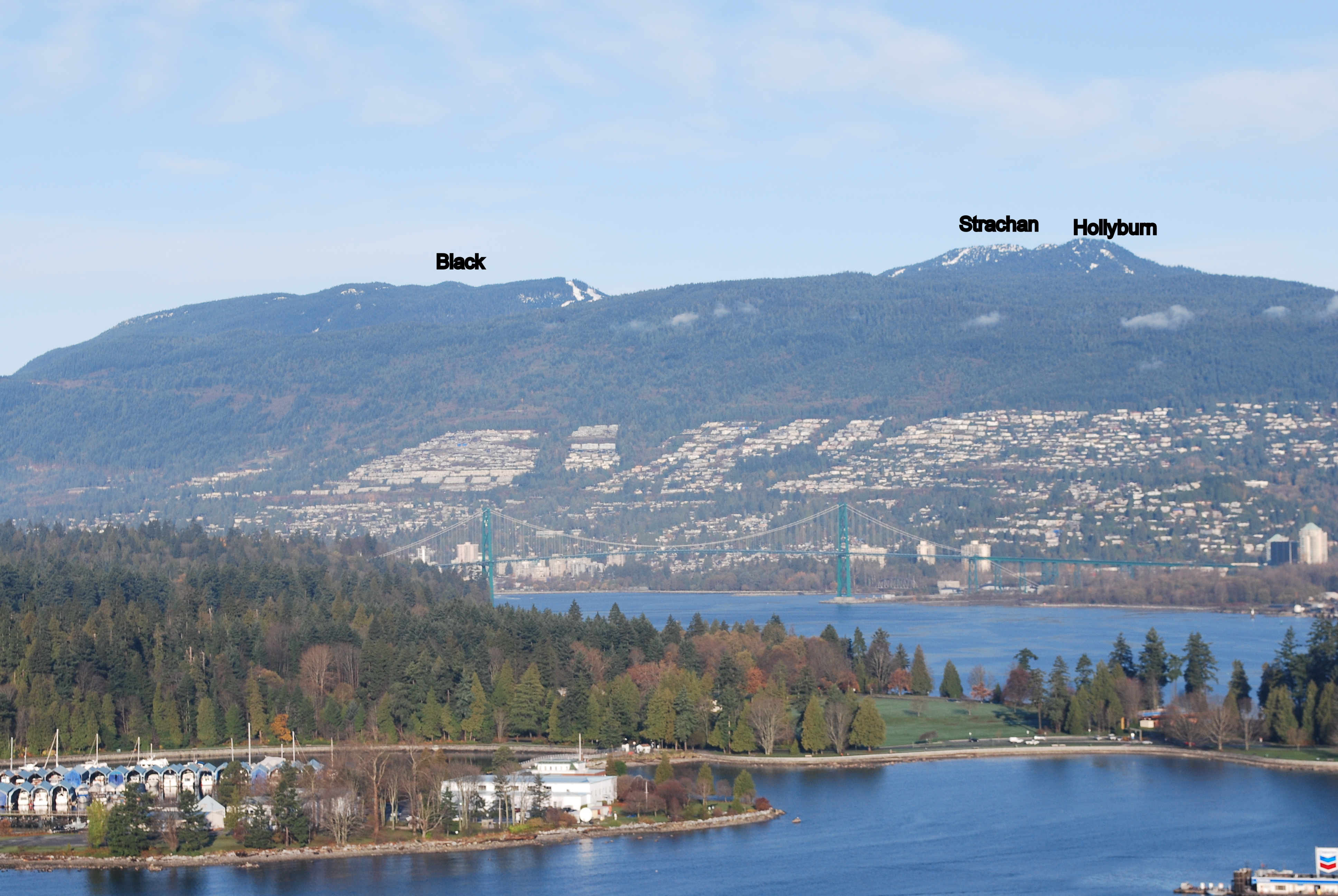
Strachan and St. Mark's
I bagged Strachan and St. Mark's on Saturday afternoon. I started from the Cypress lot. I went up the Strachan trail to its peaks, then down the gulley on the trail next to Montizambert Creek to the HSCT. From there it's just out and back to St. Mark's. If anyone is missing a knife, I found one at the viewpoint near St. Mark's summit.
On Strachan North peak.
Strachan North peak
Knife found near St Mark's
Near St. Mark's summit
Sunset from Bowen lookout
Lovely photos!
Lovely photos!
Mob Bag - FRO
Sunday 8 September was the 10th annual Mountain Highway Madness... a 15K run up and down Mountain Highway in North Vancouver. Some folks do the 15K loop several times.
Given that Mount Fromme (FRO) is not that far from the MHM turnaround, I thought I'd do a custom version of the event and bag a peak while I was at it. It took surprisingly little arm-twisting to convince most of the field to join me.
It was a mob scene at the peak. To my knowledge, it was the largest number of bagger to simultaneously bag a peak in the Bagger Challenge. Many enthusiastic newbie baggers where part of the mob.
Some notes:
Please credit the following mob with FRO:
Congrats to all!
ELS
Went up Elsay with my pal Kate on this socked in Sunday morning for my 20th bag of the season!
FRO
A little bit of an epic failure led to a lonely bag of FRO today:
http://clubfatass.com/calendar/fallmhm/2013#comment-7285
'Missed 'ya!
Ha ha ha
CFA-HAT-HAR
Brilliant weather this past Saturday on Labour Day weekend. I knew it would be a fantastic day to spend some time on and around the Howe Sound Crest Trail. It was even a wee bit nippy near sea level at Lion’s Bay for my 8am start but it would warm up soon enough.
Had to park at the school back down the road from the Lion’s Bay trailhead. 7:00-7:15am seems to be the dividing line on summer weekend days for being able to secure one of the few parking spots at the trailhead. But while I used to hustle to try to get one, it’s really not that big of a deal if you miss out, as it was only a 7 minute light uphill jog from the school to the trailhead and faster coming back down at the end of the day.
Up the logging road until the well-marked colorful sign for the Brunswick Trail which veers to the left. It was no surprise that I encountered only 2 humans and 1 dog between hitting the trail turnoff and returning to the logging road via the Harvey Trail several hours later, but what was a pleasant surprise is that I encountered only a few more bugs than that.
The short flat stretch from the turnoff to Magnesia Creek is usually a great early chance to get the legs moving, but on this day there were at least half a dozen places where thin logs were across the trail. Too many to be coincidental it would seem. But while most were too high to hurdle over on the fly yet too low to limbo under, you simple had to slow down for a bit for easy stepovers. Magnesia Creek was easy to walk over with only a splash or two on your shoes, and after deliberately dunking my head into the creek it was onto the climb upwards, starting with a narrow fire road before the single track began.
One of the things I like about the Brunswick Trail is that because the steep final grunt up to Brunswick Mountain begins AFTER you pass the intersection with the HSCT, you can actually get up to the HSCT without too taxing of an effort, although you do need to gain a lot of elevation from Lion’s Bay. At the Brunswick Trail-HSCT junction at N 49.48592 W 123.20550 I headed left (north) towards Hat Pass where I would connect to the trail to my first two destinations – Fat Ass Peak and Hat Mountain. Last year when I bagged Brunswick Mountain and had my eye on bagging Fat Ass and Hat on a foggy day I missed the Hat Mountain turnoff from the HSCT and before I knew it had sailed down to Brunswick Lake. But with better tips and research as to where is the trailhead and with a more careful eye on a clearer day, I was able to find the flagging this time with no difficulty at N 49.49007 W 123.20439 , merely 5-10 minutes after leaving the Brunswick Trail. There was a patch of water to the right, the trail headed to the left.
While not the entire route from the HSCT to Fat Ass and Hat and back was runnable, much of it was and all of it was easy to follow. When atop Fat Ass Peak looking ahead to Hat, I first exited the summit to the right but quickly realized there were cliffs there and that instead exiting to the left was the correct way. Soon I reached the peak of Hat Mountain and its distinctive giant green phallic object. Great views of Howe Sound to the west, Brunswick to the south, and Hanover among others to the east.
Back to the HSCT and headed south and wanting to bag at least one more peak, I had a choice between Brunswick or two peaks close to Magnesia Meadows – David or Harvey. I selected Harvey, as climbing it from the northeast and then following its ridge to the Harvey Trail and back to Lion’s Bay would make for a nice loop. The turnoff from the HSCT to Mt. Harvey at N 49.47583 W 123.19355 led to my slowest stretch of the day – at least 15 minutes to go 100m. Not because of any trail difficulty, but because of the abundance of blueberries. Once I started eating one it was hard to stop and I had to drag myself away from them after a quarter of hour – I can certainly vouch for what Eric was saying about the quality of the berries!
The trail up Mt. Harvey from Harvey Pass is steep but without much exposure or cause for any nervousness (at least not uphill – I could see one 5-minute stretch being more uncomfortable going down for average baggers like me if a wet day). Well-marked and gets you to the peak quickly. Great views of The Lions from this peak and then a nice largely-runnable ridge route before you say goodbye to The Lions at a clearing and head down into the forest onto the Harvey Trail and then onto the logging road back to Lion’s Bay.
Great day on the trails. I was out there for around 7 ½ hours, but that included a good 1 hour if not more of stops for pics and breaks, and hustling could shave more time off that if one were facing time constraints. September is my favorite bagging month, so I look forward to what the coming weekends have in store.
Diaper-Bag SLY
So we headed up Lynn Peak. We share the load, Brendan likes the aluminum-framed Deuter Kid Comfort III (thanks Daggs for recommending it - we found one on Craigslist practically brand-new!); but I prefer our soft backpack (Lillebaby Everywear, for those who care). It's hilarious though: when I'm wearing her, you basically can't see her from the front, so we get these odd puzzled looks when she's making her yelly squeaky baby noises but all people can see is two adults! We also get a lot of double takes or shrieks of laughter when we've passed someone.
Got up in just under 2h, then backtracked to the viewpoint to eat some snacks (and *not* share with the super-aggressive chipmunk!).
We met a forest service ranger & mentioned a lot of blow-down on the trail to SLY and he was like, "Oh, you're not supposed to be on that trail! It's not on the map". Whatever. It's on my map, which is obviously better than his map :) [no, I get it, it's decommissioned and they don't want the General Public going up there. Which is unfortunate 'cause that part of the trail is basically the prettiest bit! Although SLY itself is really nothing to write home about and we didn't think it was prudent to go any further]
So there you have it. Our first diaper bag of the year. Hopefully the weather stays nice-ish and we can hit a few more, I have great memories of the gorgeous fall foliage last October when peak-bagging! Although diaper bagging with a 6-week-old is in some ways much easier than diaper bagging with a one-and-a-little-bit-year-old...
Thanks for hosting this Challenge which gets us out to do stuff in places we probably wouldn't otherwise bother to go, on days we otherwise might not go out!
CN1/Godmother expeditionary force
Soundbite: a steep climb leading to an unique view of the Camel and the Hanes Valley
Caution: Remote. No flagged trails. Steep sides.
Round trip distance: 30K from Lynn Headwaters Park
Prominence: 158m
Bang for buck: 3/5
Difficulty: 4.5/5
Snow free: from late July
Peak view: 4/5
Must-sees en route: blueberries. If from east: zinc mine remnants, old growth trees.
Scenery: 3/5
Kids: not suitable
Dogs: not suitable
Runnability: 1/5
Terrain: largely bushwhacking (from west) or scrambling (from south)
True peak location: westmost bump
Access: from Lynn Headwaters or via Grouse Mountain
Public transit: 208/209 bus to Lynn Headwaters
Cell coverage: spotty
Sun: mostly exposed for peak approach. Hanes Valley and Grouse Mountain trails mostly covered
Water: ample water from Hanes Valley approach. Little from Grouse Mountain approach. No drinkable water on ridge.
Route links: could link with Perrault.
Name origin: "Sleeping Beauty" theme: written by Perrault. Named by Robin Tivy of Bivouac.com
Name status: unofficial, from circa. 2013
First ascent: unknown
Headwaters: tributaries of Capilano River and Hanes Creek
Best views from: Hanes Valley, Crown Mountain
Other write-ups: useful online and paper sources: none
Crown N1/Godmother is the newest Bagger Challenge Peak. It is the west-most and highest peak on the west-east ridge running from Crown to Burwell (although not accessible from either of those peaks absent ropes). Its two names were both bestowed upon it by Robin Tivy, an experienced mountaineer whose Bivouac.com provides a great service to local adventurers, and which should be an annual subscription for anyone reading this. Although a bit twee and Disneyfied, the new name of Godmother Peak is presented as consistent with the "Sleeping Beauty" theme ("Sleeping Beauty" being a legitimate older name for West Crown Peak), whence the names for Spindle (the shorted but pointier peak between CN1 and Crown) and (Charles) Perrault peak are also derived.
There are two approaches: from the south, starting at the east (bottom) end of the Hanes Valley boulder field or from the east, along the Perrault ridge, attained via a bushwhack from its east end and through a 1950s zinc mining camp. Both lead to a final peak assault that pushes comfort levels.
Our ascent route is marked below in dark purple (the pinkish purple is an earlier ascent and descent of Perrault). There were several false starts. We ascended too high up the Hanes Valley Trail boulder field, anticipating an easy traverse NE. In fact, this route took us to and through a nasty copse of alders and devils club: not recommended. And then a snow field. And a descent and a climb.
The better route (albeit a hypothetical one) is marked by a thin lavender line. From near the base of the boulder field, drive NW straight towards a rockslide/creek below the peak. Apart from some minor bushwhacking, it should be a boulder scramble up to a creek. Then a few careful hand-climbs up a few short rock faces. If in doubt, veer right. This will lead to a balcony in front of a near-cliff on south face of CN1. At this point, veer right again, into shrubbery. And then out onto a long rock slab resembling those on the ascent of Crown. Up and around to the base of the peak itself. The peak proper is claimed from the right/east, up to a false summit, and then as far west as you can.
This was roughly the route of the intrepid Dave Berg, the first Bagger Challenge guinea pig for Crown N1.
On the peak, magnificent views of the back-side of The Camel and Crown, along with the Howe Sound Crest Trail peaks, the watershed road, Capilano Lake, Sky Pilot, the Garibaldi Peaks, and the entire Hanes Valley will greet you.
The approach from the east is safer, but still dicey, especially for the final ascent, as shown in Old Matt's photo above. Ascend the Perrault Ridge to the zinc mining camp, as set out in other reports. On the ridge, instead of heading NE to Perrault, head W. You'll climb up and down two minor peaks topped with tarns. Although there are steep spots, the route is generally sensible and doable. The best tip: DO NOT try to skip the peaks by traversing along the side: although the contour lines look appealling, both of our attempts to do so led to burly and bushy and steep exercises in pain and futility.
Bill, Neil and I were glad that we went, especially given the spectacular long-weekend sun. But it taxed our comfort levels, and it should not be attempted in less-than perfect conditions: those rocks would be a slippery death-trap.
Here's the link to Dave Berg's CN1 trip report
All hail Dave "Bergsteiger" Berg, the the First Bagger Challenge Bagger of CN1!
http://www.clubfatass.com/events/bagger-challenge-2013#comment-7170
Outstanding TR!
Saw you from Crown. Heard you guys and could almost throw a rock and have hit you, but no way to get to where you were from where I was.
Wondering if there might be an even easier bushwack in from the west?
PER and CN1
After having test-driven both of these peaks, prudence dictates that they be graded as "unofficial".
They are far-away and gnarly, with no flagged trail and a few opportunities for grave injury or confusion.
That said, they provide amazing views and fascinating mining history, and still count as one point per bag.
Trip report to CN1 to follow.