WHAT: See how many North Shore peaks you can run up and bag in a summer. All but the island mountains qualify as munros (in excess of 3000 feet) under the Scottish peak-bagging system.
DATE: Between July 1 and October 22, 2009.
WHERE: non-technical or less-technical (Class 3 or easier) North Shore mountains (listed below). Although I can't list them all, I'll record peaks in Fraser Valley, and Squamish to Whistler peaks (although if push comes to shove, and there is a tie, the listed peaks will be counted). Official totals below are in brackets.
RESOURCES: For routes, etc. it is recommended to visit Bivouac.com or clubtread.com.
RESULTS: Email me your mountainous conquests, with the dates, and I will post ongoing standings. As I’m lazy, wait until you have three or four bagged before sending them in.
PHOTOS: Photos posted so far: http://www.flickr.com/search/show/?q=baggerchallenge2009
Please post your photos, too, via the CFA Flickr site: http://www.clubfatass.com/photogalleries (instructions here: www.clubfatass.com/help/image It's easy!). Please tag your photos: ClubFatAss ClubFatAssEvents BaggerChallenge2009 (space separating each tag on the flickr template)
WINNING TIE-BREAKER MECHANISM:
In the case of a tie for first place:
1. non-core peaks (i.e. those not on the North Shore and not listed) will not be counted;
2. if still a tie, the bagger with the most photos posted on the CFA Flickr website will win;
3. if still a tie, the bagger with the most unique bags (i.e. peaks that no one else visited) will win;
4. if still a tie, the bagger with the most obscure/difficult bags (at the completely arbitrary discretion of the host) will win.
NO SANDBAGGING: all claims to bagging a peak must be submitted as promptly as possible (in most cases, within 3 days) of the actually climb (perhaps more if you have to stay overnight), and climbs of more than two weeks old will be stale-dated. Amnesty for submitting late peaks: October 4th
PRIZE: The winner will be the proud bearer of the CFA Bagger Quaich cup for the year: the appropriate cup from which to drink a winter whisky and contemplate how awesome you are.
There will be an auxiliary prize for the person who draws the most other people into the cult of peak-bagging.
BAGGERS' BANQUET: To cap off the bagging season, we will be hosting a barbeque for all bagger participants and their significant others. Bagger burgers (meaty and veggy) will be served. The Bagger Quaich will be awarded (unless the host wins, in which case there will be awkward silence on this topic).
Date: Friday, October 23rd. From 6pm.
Place: 1368 West 21st Street (near Capilano Elementary School, in Pemberton Heights).
RSVP jeldac "at" shaw "dot" ca
Entry: There is no fee and you don't need to be a member of Club Fat Ass to participate in a Flash event, however whining is not allowed. That being said, many of the peaks listed should only be attempted by those with the experience and fitness level of a typical Club Fat Ass member (i.e. ample mountain running experience over long distances).
No registration is required but please send your report of bagged peaks (wait until you have 3) to David (as a member you can click on David's user name and message him; if you are not a member please use the comment function below).
Important safety considerations: All of these adventures are potentially dangerous.
Mountains marked with a ** are scramble ascents or otherwise exposed or otherwise remote and undeveloped and should only be attempted by experienced climbers wearing helmets, etc. Don't try these routes in anything but perfect weather.
Use great caution when rocks are wet -- slipping is the cause of most accidents on North Shore mountains.
Always run/hike with a buddy.
You are responsible for your own well being and safety and should be self sufficient.
Here are two useful lists of "MUST HAVE" survival items that all participants should carry:
http://www.clubfatass.com/blog/ean-jackson/baggers-essential-companion
http://www.northshorerescue.com/whattobring.html
Release of All Claims. By participating in this event you agree to be wholly responsible for your own well-being and agree not to sue anyone associated with this event or Club Fat Ass or any person in relation to this activity. By participating in this event you agree to the terms of the Release of All Claims.
QUALIFYING MOUNTAINS (ranges from west to east)
Howe Sound Islands
- Mt. Liddell (Gambier Island) (904m) (LID)
- Mt. Killam (Gambier Island) (844m) (KIL)
- Mt. Artaban (Gambier Island) (615m) (ART)
- Mt. Gardner (Bowen Island) (727m) (GAR)
- Leading Peak (Anvil Island) (765m) (LEA)
Lions/Howe Sound Crest Trail Area (&&& = new route HSCT passes right over these peaks: old route drops down east towards Hanging & Enchanted Lakes, bypassing James Peak) maps.google.ca/maps/ms
- St. Mark’s Mountain (1355m) (MAR) &&&
- Unnecessary Mountain (1548 m) (UNN) &&&
- West Lion (1654m) ** (LIO)
- James Peak (1466m) (JAS) &&&
- David Peak (1480m) (DAV) &&&
- Mount Harvey (1652m) (HAR)
- Brunswick Mountain (1788m) (BRU)
- Hat Mountain (1644 m) (HAT)
- Wettin Peak (1538m) ** (WET)
- Mount Hanover (1748 m) ** (HAN)
- Mount Windsor (1689 m) (WIN)
- Deeks Peak (1672 m) (DEE)
- Gotha Peak (1641m) ** (GOT)
- Capilano Mountain (1685 m) (CAP)
Cypress Group
- Black Mountain (1217m) (BLA)
- Hollyburn Mountain (1325m) (HOL)
- Mount Strachan (1454m) (STR)
Grouse Area
- Mount Fromme (1185m) (FRO)
- Grouse Mountain (1231m) (GRO)
- Dam Mountain (1349m) (DAM)
- Goat Mountain (1401m) (GOA)
- Little Goat Mountain (1323m) (LIL)
- Crown Mountain (1504m) (CRO)
- West Crown / Sleeping Beauty Mountain (1400m) (WCR)
Lynn/Cathedral Range
- Lynn Peak (1015m) (LYN)
- The Needles (1258m) ** (NEE) (nb South Needle at 1163m qualifies for a bag -- see below)
- Coliseum Mountain (1441m) (COL)
- Mount Burwell (1541m) (BUR)
- Cathedral Mountain (1737m) ** (CAT)
Fannin Range
- Mount Seymour (1449m) (SEY)
- Runner Peak (1370 m) ** (RUN)
- Mount Elsay (1419m) (ELS)
- Rector Peak (1270m) ** (REC)
- Curate Peak (1266m) ** (CUR)
- Vicar Peak (1247m) ** (VIC)
- Mount Bishop (1509m) ** (BIS)
- Deacon Peak (1495m) ** (DEA)
- Presbyter Peak (1487m) ** (PRE)
- Mount Dickens (1288m) ** (DIC)
FINAL STANDINGS (October 22nd) [of 44 peaks in total] [Peaks and totals in square brackets = total 2009 bags from official list (including those outside Baggers Challenge time period]
Ken Legg: 42(41) [42/44] : BLA, HOL, GRO, CRO, WCR, SEY, RUN, ELS, LIO, MAR, UNN, JAS, DAV, HAR, BRU, LIL, DAM, LYN, COL, BUR, CAT, REC, CUR, VIC, BIS, DEA, PRE, DEE, WIN, GOT, GOA, HAN, HAT, WET, GAR, CAP, NEE, ART, LEA, FRO, STR, [LID] Fat Ass Peak [left: DIC, KIL]
Ean Jackson: 41(40) [40/44]: BLA, DAM, GRO, GOA, FRO, SEY, RUN, LYN, COL, BUR, HOL, STR, LIL, CRO, WCR, LIO, JAS, DAV, HAR, BRU, MAR, UNN, GAR,ELS, REC, CUR, VIC, BIS, DEA, PRE, DIC, HAT, WIN, DEE, WET, LID, NEE, ART, LEA, KIL, Fat Ass Peak [left: CAP, CAT, GOT, HAN]
David Crerar: 41(40) [44/44] : ART, BLA, SEY, BRU, HAR, LIO, UNN, MAR, HOL, STR, GRO, DAM, LIL, CRO, WCR, GOA, FRO, LYN, NEE, COL, CAP, GAR, RUN, ELS, REC, CUR, VIC, BIS, DEA, PRE, DIC, HAT, JAS, DAV, GOT, WIN, DEE, LEA, HAN, WET, [BUR, CAT, KIL, LID], Middle Needle, Fat Ass Peak
Glenn Pace: 36 [36/44]: BLA, DAM, GRO, GOA, UNN, MAR, JAS, DAV, SEY, HOL, STR, LYN, LIL, CRO, WCR, COL, BUR, FRO, NEE, GAR, LIO, HAR, BRU, RUN, ELS, REC, CUR, VIC, BIS, DEA, PRE, GOT, WIN, DEE, ART, LEA [left: CAP, HAN, HAT, WET, DIC, CAT, KIL, LID]
Tundra the Ultra Dog: 32 [32/44]: JAS, DAV, HAR, BRU, HOL, GRO, DAM, LIL, CRO, WCR, LYN, COL, BUR, CAT, SEY, RUN, ELS, REC, CUR, VIC, BIS, DEA, PRE, DEE, WIN, GOT, GOA, GAR, CAP, NEE, FRO, STR
Neil Ambrose: 20(18): BLA, COL, BUR, GRO, FRO, DAM, CRO, LIL, GOA, HOL, STR, GAR, LYN, SEY, ELS, MAR, UNN, NEE, Golden Ears, Fat Ass Peak
Carolyn King: 16(13): GRO, HOL, STR, BLA, GAR, LYN, SEY, ELS, MAR, DAM, GOA, LIL, NEE, Golden Ears, Burnaby Mountain, Fat Ass Peak
Craig Moore: 14: BLA, FRO, GRO, HOL, STR, MAR, UNN, LYN, NEE, DAM, LIL, GOA, LID, KIL
Wendy Montgomery: 14(13): DAM, LIL, CRO, WCR, STR, LYN, FRO, GRO, ART, BLA, NEE, MAR, UNN, Fat Ass Peak
Dave Berg: 13: BLA, CRO, WCR, GOA, COL, BUR, SEY, LIL, DAM, GRO, FRO, LYN, NEE
Mike Wardas: 11: SEY, LYN, COL, BUR, GRO, DAM, LIL, CRO, GOA, FRO, DEA
Ryan Conroy: 11(8): BLA, DAM, LIL, CRO, COL, LYN, NEE, COL, Gate, Middle Needle, North Needle
Paul Cubbon: 8(7): BLA, STR, GRO, DAM, GOA, HAT, DEE, Fat Ass Peak
Monty Watts: 7: BLA, LYN, HOL, GRO, SEY, BRU, HAR
James Clarke: 6: GRO, CRO, ELS, DAM, COL, BUR
Harry Crerar: 5: SEY, ART, GAR, STR, DAM
Rick Arikado: 5: BLA, GRO, LYN, SEY, RUN
Jason Oliver: 5(4): MAR, UNN, LIO, GRO, Golden Ears
Pippa Crerar: 4: SEY, ART, STR, DAM
Heather Urquhart: 4: MAR, UNN, LYN, NEE
Meggan Oliver: 4(3): MAR, UNN, LIO, Golden Ears
Janice Vallis: 4(3): BLA, GRO, SEY, Burnaby Mountain
Sibylle Tinsel: 3: STR, LYN, BLA
Kirsten Ramage: 3: BLA, GRO, LIL
Curb Ivanic: 3: BLA, HOL, STR
EJPowderhound Jackson: 3(2): STR, LYN, Fat Ass Peak
Glenn Dorey: 2: ART, LEA
Doug Keir: 2: LYN, GRO
Kathryn Webb: 2: LYN, GRO
Simon Cowell: 2: BRU, BLA
Donald Golob: 2: HOL, STR
Jojocheesepig Jackson: 2(1): STR, Fat Ass Peak
Rob McDonald: 1: DEA
Olav Brusletto: 1: NEE
Jill Warland: 1: BLA
Marilyn Tschirhart: 1: GAR
Ron Tschirhart: 1: GAR
Peter Rietveld: 1: GAR


|


Comments
The siren song of the Mountain Woman
I think Pace set me up ...
...with that photo. My judgment was impaired by a pound of delicious delicious grease.
Sorry to Hear about Wettin
What... after all of the grief I went to in order to flag the route to Wettin for you?
We may have to hold another Bagger Council meeting to discuss Gotha. According to your report, I believe I bagged it a couple of weeks ago. See photos. That, or maybe you 2 didn't! Ha ha ha.
BTW, you didn't take the Cubbon-Jackson trail down from Deeks, did you?
Having done some recent research....
...it seems that "Wettin" is from the original Coast Salish word "Tse' Whe-tyn" which loosely translates to "obsessive runner". That, or it's the name of the god of bush covered lumps of earth.
Montbatten
The information below will be abundantly well-known to all CFA members, but forgive me for reprinting the source of the names of the peaks in that area.
I suppose that it should be pronounced "Vettin".
(and where's Saxe Peak?)
[from Wikipedia]
The House of Saxe-Coburg and Gotha
The senior Ernestine branch lost the electorship to the Albertine in 1547, but retained its holdings in Thuringia, dividing the area into a number of smaller states. One of the resulting Ernestine houses, that of Saxe-Coburg and Gotha, went on to contribute kings of Belgium (from 1831) and Bulgaria (1908 - 1946), as well as furnishing consorts to queens regnant of Portugal (Ferdinand II of Portugal) and the United Kingdom (Prince Albert, husband of Queen Victoria), as well as to Maximilian I of Mexico (Carlota of Mexico, the first Belgian princess). As such, the British, Portuguese, and for a time, Mexican, thrones became a possession of persons who belonged to the House of Wettin.
From George I to Queen Victoria, the British Royal family was variously called Hanover, Brunswick and Guelph. In the late 19th century, Queen Victoria charged the College of Heralds in England to determine the correct personal surname of her late husband, Prince Albert of Saxe-Coburg and Gotha - and, thus, the proper surname of the Royal Family upon the accession of her son. After extensive research they concluded that it was Wettin, but this name was never used, either by the Queen or by her son or grandson, Edward VII and George V of the United Kingdom; they were simply called 'Saxe-Coburg-Gotha'.
Gotta get Gotha
1. Did you two gentlemen in fact get Gotha, then? Shall we record successful baggage?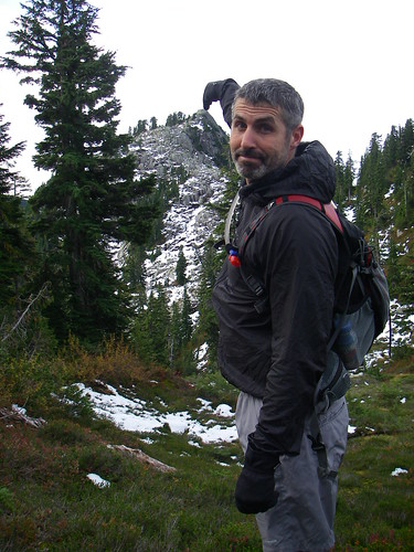
Our helpful alpine hand-model Glenn is pointing it out (actually a little beyond that) in this stunningly-composed photo.
This is shot from a meadow to the east of and down from (and a bushwhack from) the Gotha-Windsor col meadow. There's an idyllic little lake here.
Gotha Peak is a bit of a trek from the Gotha-Windsor col meadow; not really a quick side-trip despite the relative closeness as the gray-jay flies. From the peak the view of Mt Hanover is only obscured by the green mass of Coburg Peak (not a listed peak).
From the Gotha-Windsor col meadow there is a minor nubbin peak separated from the Gotha ridge peak by a sharp valley. We went up that peak first, thinking that the nubbin peak led to Gotha Peak. When we hit cliffs we saw that it did not, and we backtracked back and down and east.
Both the real peak and the nubbin peak are accessed via rockslide slopes, but the Gotha rockslide is considerably longer and steeper and rockier, leading to a stretch with a bit of hand-and-knee rockclimbing. Gotha is a pretty cool-looking peak, while the nubbin is a boring hill. You'd know Gotha if you did it.
Did you & Paul bag it, accidentally or otherwise? If so, let's put you down for GOT.
2. We didn't take the patented Cubbon-Jackson descent route: we essentially did the same route both ways, but, from the col between the two Deeks Peaks, avoided a long traverse by dropping directly down through un-bushy but steep forest to rejoin the same trail we came up on.
If That's Gotha, Then I Done Done it!
Woo hoo! Take that, Tundra, you old hound dawg!
Why doesn't it just say "Gotha Peak"?
Here is a photo of same peak on 26 September from over the ridge behind the little lake.
Paul opted to work on his tan beside the lake in the Windsor/Gotha col, as you called it. Not knowing if this was indeed Gotha, I figured I'd give Paul some space for an hour and climb up there... JUST IN CASE!
The reward was breathtaking. I didn't want to keep Paul waiting too long, so I didn't dawdle long. While at the peak, I noticed some orange tape that descended the opposite side of this mountain. Given my legs had been scratched to ratshit by that point, I opted to go for the flagged route.
For once, I made a good call! It was an excellent, and relatively well-marked route through fairly solid skree. The tape ended up at the opposite side of the little lake where I started. (e.g. directly opposite the trail you came up on from Deeks Lake.)
Ummm....That's Windsor.
This is Windsor. This is the same shot as yours (snow optional). Check out the trees near the summit as well as the large rock in the mid-field.
Almost a perfect 'Grouse Sweep'
Hey gang,
I finally had a chance to read some of the recent 'rules' and have to submit my 6 for 7 peaks on the Grouse sweep. Sept 20 I started from the Grouse Parking lot and climbed up the BCMC with a not so light pack and hiking poles. Squarley defying the need to 'run' but only hike fast. Topped out at the top of the BCMC in just over 55 minutes, tried the direct approach to GRO but there was too much construction and DO NOT ENTER signs, so I went around via the road to DAM. Bagged GRO then bagged DAM now off to LIL. Bagged LIL then drop down to Crown Pass to do CRO. It's a long ways to CRO especially when you know you are coming back the same way you left!
Hiked up to CRO and took some amazing pictures. All the while on my ascent I was looking for the entrance to West Crown/Sleeping beauty. Once I got to the top I tried phoning Glenn to see if he could tell me, but alas there was no cell phone reception. Back down Crown and stopped at a couple of spots that looked like entrances to West Crown, but could not find it.
Back up Crown Pass to tackle GOA. From GOA I hiked back to the main trail back to the Grouse resort and turned onto Thunderbird ridge. Traversed Thuderbird ridge till I reached Pipeline Pass. Took Pipeline Pass down the mountain. It's very steep and very beautiful in there. At the bottom of the trail there is another trail that leads up to North Fromme (Senate peak) which I don't suppose counts as a peak but I'll ask anyway. Took the main trail to Fromme proper.
8 hours has passed and now all I want to do is get back to my car. The decision is to whether or not to go down the remaining trail (South) to the gravel Mtn. Hwy road and then traverse along the BP and/or Skyline back to the Grouse parking lot OR to retrace my steps heading North to Senate peak and then descending back down to the gravel road and then hike up to Grouse and take the tram down.
I opt for option 2. So I think I'm pretty smart, I'll make it to the top of Grouse within an hour by cutting straight up the gravel road switch backs get food and take the tram down for $5. But once I get close enough to the lodge I see a huge line-up of people almost all the way to the helicopter pad! Yikes! Grouse Grind Mountain run...
So just as I'm getting over that sight Rod and his running buddy show up after running the Hanes Valley and they decide to run down the BCMC. Well I'm just about knackered and figure if I join them I'll get it over with quicker. Now I have to 'run' with my biggish' pack and poles and I have to say it was not fun!
All said and done I finished the run and arrived at my truck in just under 10 hours! I've tried posting pics and I just can't figure it out so you can see them at the Picasa link here: http://picasaweb.google.com/adventuremikew/PeakBaggerChallengeGRODAMLGOATCROGOATFRO?authkey=Gv1sRgCOny1qCL7uW55AE&feat=directlink
So peaks to claim are: GRO, DAM, LIL, CRO, GOA, FRO (and Senate SEN if it's applicable?)
Cheers,
Mike
Seymour Sweep: GPS/Google Earth
Some images of the 23 September epic adventure, thanks to Garmin & Google Earth.
Epic trail run along Indian Arm Trail, from Mt Seymour parking lot to Mt Dickens and beyond.
Mountains around rim of Elsay Lake, on Indian Arm Trail. (L-R/S-N: Elsay[W], Rector, Curate, Vicar, Bishop [W] [and then to north/right of Bishop:] Deacon, Presbyter; Dickens in distance)
[L-R/S-N] Fannin Lake, Mt. Dickens and Brokeback Mountain (see last, remote yellow dot to the NW of Wigwam Inn, indicating where the GPS was turned on briefly before the batteries died). Note logging cutblock and valley east of Fannin Lake, where one could probably descend to Indian Arm)
Descent to Wigwam?
'Round about daylight when we were looking for the Brokeback... uh, Dickens promontory, I am sure I saw orange flagging tape going steeply downhill. It would make sense that the overgrown trail Tim referred to drops down that gully, as Wigwam is at the end of it. Wonder how we can confirm? Anyone out there in Internet land have a clue?
Questions:
WTF Peak....
....is a good name for it: let it be so benamed.
and NB Wigwam Inn is misplaced on Google Maps
It's actually snuggled up against the west (top) side of Indian Arm, at end.
Mount Fat Ass
The Challenge has highlighted the large numbers of sad, unnamed peaks in our backyard.
Happily there are many worthy names that sadly have yet to have peaks attached to them.
What say that we call the peak separating Hat from the HSCT "Mount Fat Ass"? It might even catch on.
Or other nominees for this honour?
Brokeback Mountain (BBM)
Formerly the obscure Dickens 2, I'd like to nominate this peak. To my knowledge, only 2 baggers can claim it this year.
I'd like to see a photo of this one!
.
Mount Fat Ass (FAT)
Could be a slippery slope, so to speak. Now you have to go back and credit everyone else who did HAT with FAT... that is, assuming they didn't descend the ornery face we ascended.
Mount Fat Ass
David we concur with that ruleing...Please add Mount Fat Ass for Ean, Wendy, Neil, Eric and Carolyn.
Cheers!
Carolyn
Hats off to HAT!
Great outing Ean, Sybille, Eric, JoJo and Wendy!
We made it back to the car just after sunset. It was a bit tricky going down the Howe Sound Crest Trail in the dark! We felt a bit guilty about consuming Wendy's sandwich - thanks Wendy - we hope you had enough food for the next day! It must have been a cold night - we were thinking of you all as we tucked in. We were only a few hours late for the dinner party - our friends were getting a bit concerned that we were not out of the woods as planned. A familiar theme?
Have we convinced the judges to give us HAT? We did make it to HAT 1. I do think we modeled very good decision making keeping safety first in risky conditions.
Looking forward to our next Bagger outing...we do need to be back for dinner on Thanksgiving Monday! ;-)
Cheers,
Carolyn
Rimshots on HAT?
Jackson Gets WET
For some editorial, see my blog post on My Conversation With Mallory. If you want to bag this bad boy, read on.
The first thing that worked against me was the snow. There was a wack of it. And it wasn't supposed to be there! Second, there was no trail, so it was a bushwhack from start to finish.
From the Brunswick Lake shelter, Wendy and I went down to the brown lake and headed toward the saddle between Wettin and Hat. We bobbed and weaved a bit, but came to a nice meadow with a stream running through it at the base. We then bushwhacked directly up toward the notch, taking care to leave orange surveyor tape at roughly 25m intervals.
The hike to about 1/2 way was not bad at all for a bushwhack. We then followed a fairly narrow gully up over snowy, mossy rocks, over slippery logs and through a creek. It got steeper and steeper to the point where Wendy turned around. I went right up a small cliff then up a very steep chute. The last flag I left was in a gnarly thicket of bushes at the top of the chute. Then into the shadow of Hat across a snowy slope to a nothing outcropping of rock where I couldn't even dig up a rock to start a cairn for the next bagger! At least my name wasn't written in yellow snow as a present from Tundra the Ultradog!
Summit photo of me covered in pine needles and bleeding from the drubbing I'd endured getting to this useless peak! Windsor in the background.
It was cold and my feet were soaked and I was hungry as a bear and apprehensive about the descent, but I still took the time to look for tape or other signs of human presence in the hope that I might spare future baggers some grief by giving them helpful directions. Nada.
My escape hatch was a gully with a stream that dropped down to the middle lake between Deeks Lake and Brunswick Lake. I went down quite a ways before coming to a cliff/waterfall then went across the mountain back toward Hat. It was so steep going down I slid most of the way. Tore my favorite MEC running pants all to pieces. Tore my butt and legs all to pieces. Broke my shades. But bagged the sucker!
This is hilarious
I only put Mt. Wettin on the list as an elaborate practical joke. I didn't think anyone would actually climb the sucker.
Someone else must have climbed Wettin earlier, but I think that Ean is the first documented bagger. First bagging rights! And trail builder! And in first place! Woo hoo!
this weekend ...
Anyone want to join me for some baggage this weekend? I'm going to do something on Seymour or Grouse. Slowpokes are welcome. Fastpokes can cheer me on. I want to leave early on Saturday morning (Oct 3) to be back well ahead of dinner time.
darn small antelope
I went alone but I wasn't alone. And I have pictures to prove it. Check out my latest outing to Grouse Mountain and beyond by way of the link below to Flickr. I intended to go up Crown Mtn but the fresh snow and lack of company made me think twice. It was chilly to start but warmed up very nicely when the sun was shining. I met several other hikers including two groups of people that had been to Crown the weekend before. With the fresh snow and sunshine there was lots of water on the trail and the air was fresh as could be.
Stunning views from Goat Mountain as you can see. There are pictures of the adjacent peaks: Strachan, Crown, Coliseum, Burwell, Needles. It's nice to get some more perspective on those ones.
http://www.flickr.com/photos/
these pictures are me on DAM LIL and GOA:
By the way, Mountain Goats aren't true goats. But they're all from the same family as antelopes and cattle.
And according to the Grouse Mountain web site:
Grouse Mountain was named by the first recorded hikers to reach the summit in October 1894. In those days, climbing Grouse Mountain was a three or four day epic journey - there was no bridge across Burrard Inlet and no road to the base. The hardy group of hikers slogged through snow, scrambled over rock and up through the dense forest. Along the way, they hunted a Blue Grouse and honoured the plentiful game bird by calling the Peak "Grouse Mountain".
Awesome Photos of the Peaks!
Superb shots Craig...great work out there bagging all those Peaks!
Happy Bagging!
Carolyn
You're a fungi!
If the Bagger Challenge has piqued your curiosity about the myriad mushrooms that you have recently witnessed, the Vancouver Mycological Society is holding its very fun annual show on Sunday October 25th at VanDuesen Gardens: www.vanmyco.com/
An excellent and insanely fun book: www.amazon.ca/All-That-Rain-Promises-More/dp/0898153883/ref=sr_1_3
Best mushroom spotting runs: Frosty 50K Race route (first half); Howe Sound Crest Trail to Deeks Lake; Mt. Capilano; Weaver Lake. (Any others?: please nominate!)
Nice gloves!
HAN - Mount Hannover
Looks like no bagger has bagged this peak this year. From what I could see yesterday, it's a bad boy. Might be best to take a team approach. Beers on me at my place to any and all who are interested in discussing.
Hannover on Sat or Sunday
Thx for the details, David, and the helmet, Glenn. This weekend is looking good. With snow in dem dar hills, the window of opportunity for high peaks is clearly closing. I'm heading up to Deek/Brunswick Lake for family outing and hope to nail this one. May also try Gotha and Wettin. I fully expect to see paw prints from Tundra the Ultradog having gone before me!
HAN notes
Hanover is well described in the excellent Matt Gunn Scrambles book.
I did it last year: exhilarating approach, beautiful views.
Probably the hardest and most potentially dangerous hike of the list (even more so than West Lion). Your arms will be tired.
One climbs up a long gully/chimney of sorts. There is little real exposure, but a slip could well result in a broken leg or something similar.
The main risk is the loose rock upclimb: the chimney is like a vertical bowling alley, with rocks careening down the gully if dislodged above.
I'd highly recommend that climbers wear helmets for Hanover, and to climb the chimney one-by-one, waiting until the first climber gets to the top before the next person starts. And only do it in perfect weather.
The approach is not hard: it veers off the HSCT about 10 minutes south of the Brunswick Lake hut. The destination is clear. You go across a flat rockfield, then through a scrubby green patch, and then up a scree/boulder slope to the base. The green patch is tricky and I bushwhacked a bit but, again, the destination is clear.
Sandbaggers and Sandbaggery
Wikipedia defines sandbagging from several perspectives: car racing, climbing, chess, etc. In the context of the Bagger Challenge, I propose the following definition:
Sandbagger. A bagger or a baguette who purposefully withholds their baggage from their competitors for the purpose of stealth.
Sandbaggery. The act of sandbagging.
As the first annual Bagger Challenge enters its final weeks, the topic of sandbaggery has come up frequently on the trails. More specifically:
To the judges:
I totally agree
Such an heinous deed could not be attempted by any member of our honourable group.
I am even ashamed that Ean and I could even imagine such a scheme.
Thus Rule 19.6, sub 4: the No Sandbagging Rule:
Henceforth, all claims to bagging a peak must be submitted as promptly as possible (in most cases, within 3 days) of the actually climb (perhaps more if you have to stay overnight), and climbs of more than two weeks old will be stale-dated. Amnesty for submitting late peaks: October 4th
while on the topic ...
What makes a good and proper bagger? No doubt there have been many a discussion on the trail about what constitutes a true bag and one with fine form to boot. It is far from my place to open this can of worms at all since I still trail a dog, however, to make the worms at least gasp for a little air, here is my first whack at it:
A Bag: Get to the top laddy and report back when you're home with a dram.
A Friendly Bag: Two or more of ya did it.
A True Bag: Climb at least half way and back under your own steam, nothing motorized near the top.
An Ultra bag: Bag at least one peak whilst completing an ultra run. An extra point for the entire ultra being done on trails.
A Pure bag: One peak, starting from sea level to the peak and back. (This could cause the total number of bags in a single season to tumble quite severely.)
A Cat out of the bag: Topping a peak but admitting to arriving home with some sort of ne'er do well action ... such as a motorized peak ascent or descent, intended or otherwise. Though could be as simple as leaving your trail-illuminating-device on the kitchen counter at home and not realizing it until it is actually needed.
Seasonal bag: A series of bags in one season of the year such as Winter.
Round bag: Continuous unsupported completion of all peaks on foot. There is room for interpretation here such as the method of traversing between mountain ranges.
Pure Round bag: (see Pure bag above)
CFA bag: All peaks completed whilst a continuous member of Club Fat Ass.
And the list goes on ...
Rim Shots
Nice. Now the competition *really* begins, eh?
While we're at it, what's the difference between a bag and a rim shot?
For example, Mount Strachan, Gardiner Mountain and Mount Fromme. All of the above have more than one "peak". (The issue of The Needles was resolved in an earlier ruling by the esteemed judges.) However, in all cases, one of the summits is higher than the other... and that summit is not always the one that is commonly recognized as being the summit because it doesn't have the best view.
Does the "Close only counts in horseshoes" rule apply, or are rim shots allowed in such cases?
Not dark yet
Sadly, summer has gone and the hours for bagging are getting shorter and shorter.
A reminder of upcoming sunsets and our dwindling hours of light:
October 3 6:46pm
October 10 6:32pm
October 17 6:18pm
Don't push the hours, and always bring a headlamp and extra batteries.
Leopard-skin Pill-box Hat
This weekend was focussed not on the Bagger Challenge but the Boozer Challenge, in which I bagged a nice case of wine from Black Hills Estate and tried to drink as many bottles from as many Okanagan wineries as possible. But upon an early return on Sunday, what was one to do but bag some peaks that I should have bagged during my earlier sweep of the HSCT this year: HAT, JAS & DAV.
The latter are on the new (upper) HSCT route and are well-marked, so no further comment.
There are two approaches to Hat:
1. a side-trail off the HSCT (most quickly reached by climbing up the trail to Mt. Brunswick from Lions Bay (itself a side-trail from the main Lions Trail)
2. a dedicated "Hat Mountain" trail (described below in Ean's post) reached from Lions Bay (taking main Lions Trail, then taking the Hat/Brunswick side-trail, then taking the Hat side-trail). Although this trail is well marked with flagging tape and red paint, and although the lower reaches are nice and runnable, most of the trail is insanely steep, brutally hard, and duffy underfoot. It leads to a rock wall at the base of Hat that does not have an obvious ascent. Someone put a lot of work into this trail but I am frankly not sure why it exists.
I'd wholly recommend route #1: the HSCT approach to Hat is found in the meadowy col (look for the big boulders) between Brunswick and Hat, about .5K S of Brunswick Lake or .25 NW of the intersection between the Mt Brunswick trail and the HSCT. A nice trail, runnable in places, over two minor bumps and up to Hat with its radio tower and spectacular views.
HAT Route
Poor Paul! I promised him there would be no airy baggery yesterday. Little did I know the last 1/3 of HAT from the direct route was a hairball. For routes like this, baggers should include Depends in their Baggers Essential Companion!
First Bag For Me
HCST North Baggage - 3+ for Cubbon and Jackson
On Sat 26 September 09, Paul Cubbon and Ean Jackson set off for adventure before the crack of dawn. Our goal: bag as many peaks as we safely could along the Howe Sound Crest Trail (HSCT) and be home in time to make dinner, thereby earning brownie points for being responsible and the ongoing support of our loved ones. At least we had a spectacular day in the mountains!
Start: 07:15 at Lions Bay, BC. Prior to the start, we stashed a vehicle down the trail at Porteau Road
Finish: 19:15 at Porteau Road. After almost exactly 12 hours of non-stop baggage and bushwacking, we at least didn't have to hitch hike back to our cars. Also, didn't have to spark-up the headlamps, which was a sub-goal when all else was lost.
Peaks Bagged: Hat Mountain (HAT), Windsor Peak (WIN), Deeks Peak (DEE). The judges will need to be consulted, as there may have been another peak mounted.
Here are more photos of our HSCT adventure...
Awesome
It looks like Windsor has a little secondary nubbin peak to the east: was that what you hit? Or Gotha Peak (a long ridge peak about 1.5K to the south of Windsor, at 3 o'clock on Deeks Lake)
And did you go straight from Windsor to Deeks Peak (ie NW down into the col and then due W up the ramp to Deeks Peak? Is it fairly well marked?
They are back and fine!
4 Bags By Land ,Sea and Bike!
Carolyn and Neil bagged 4 Peaks today. Hollyburn, Strachan, Black and Gardner. Thanks for the tips David and Glenn...we had a great day! Carolyn was pleased to complete some Peaks that were actually in the series. David - could you please add another non series bag for Carolyn - Mount Royal (Montreal) ;-)
Carolyn has posted some photos on her blog at http://runandbeccome.blogspot.com/
Cheers! Neil and Carolyn - Ean...are you back yet??
what a great celebration of
what a great celebration of living in British Columbia. Excellent photos and blog write-up of this fine adventure.
oh that was nice!
Another beautiful day and more peaks to to conquer! Heather and I set out for a nice Friday afternoon stroll to Lynn Headwaters. I of course had been up Lynn Peak many times to enjoy the view of the city and Seymour Mountain but this was Heather's first treat at this climb. There was nobody else on the trail, at all, much to my surprise, and the view from Lynn Peak was very pleasant.
The trail is well marked now since NSR has done all their hard work clearing it and is very passable at this time of year. We found the trail instructions that the others have been talking about and continued to evolve our plan as we went onward. The decision was made to make the return trip on Hydraulic Creek Trail and out through LSCR.
On the way back, we made quick time down to the Hydraulic Creek Trail junction and kept a steady pace. I haven't been down the Hydraulic Creek Trail before and I would describe it as a rough BCMC Trail, similar in steepness but a bit longer. Lots of big trees and great trail running there. Then we popped out on the Seymour Trailway and ran home. I'm in Lynn Valley and Heather has her new home near 12th and Lonsdale. She's happy to be in paradise now ;)
That was my first time up the South Needle by the way. Dave please put us each down for a LYN and a NEE.
And for those of you poetically inclined ... this could apply to any two of the people in the bagger challenge and perhaps some more than others (sung to the tune of Three Blind Mice):
Two climbing grice, didn’t think twice,
See how they run, up and down for fun,
They both ran after the quaiche device,
To fill with some drink and to be precise,
Did you ever see such avarice,
From two climbing grice?
Nice grice!
I pride myself on a pretty decent vocabulary, and a love of things Scottish, and was delighted to learn a new cool thing thanks to your poem:
Grice (extinct pig)
From Wikipedia, the free encyclopedia
The grice was a type of swine native to the Shetland Isles of Scotland; similar pigs also occurred in the Highlands and Islands. Small in size, yet ferocious, this domesticated breed of pig fell out of favour with crofters during the late 19th century and became extinct.
Accounts suggest grice were aggressive animals with small tusks, an arched back, and a coat of stiff dark bristles over a fleece of wool. Like other species on the islands, grice evolved to be small and hardy to survive the harsh environmental conditions.
"Grice" is a Scottish and northern English dialect word originally meaning "young pig" (Scandinavian: gris).
Most Shetland crofts would have at least one grice kept on grazing lands, though they would often roam across adjacent farmland, rooting up crops and occasionally attacking lambs. This behaviour led to the passing of a "grice law" fining the owner £10 plus the cost of any damages caused by rogue grice. This was such a problem that the townspeople would refer to their damaged property as being "griced."
In the 1800s, landowners discouraged the keeping of swine on island crofts. This, combined with the increasing import of other breeds from the Scottish mainland, resulted in a dwindling grice population, and by the 1930s the breed was extinct. The legacy of grice remains, however. The wild bulb squill is known locally as grice's onions because it was a favorite food of the swine.
In 2006 curators at the Shetland Museum and Archives commissioned a taxidermist to recreate a grice from the stuffed body of an immature wild boar. As no-one alive had seen a grice, the accuracy of the model relied on descriptions in "published sources ... investigated artifact and archaeological findings". The model grice went on public display in spring 2007.
Hello, my name is ...
Hello, my name is (pick from bagger's score list above) and I'm an ultrarunner, mountain bagger etc.
See funny article at:
http://www.vhtrc.com/forum/Brian'sNightmare.htm
Don't miss out on taking the test midway through that article "20 Questions about Ultrarunning Addiction"
That's not so bad, right???
I'm 'only' an 8 of 20 - that's not so bad, right??? Thank goodness I'm not in the 'den of iniquitous baggable mountains' on the North Shore of Vancouver.
Oh, wait, but I DO wish I were able to compete in the Bagger Challenge.
Damn it. I guess I'll see you guys in rehab...
Jason
Gotta work sometime...
Also have to do chores around the house, take care of the kiddos, wash the laundry, vacuum, go grocery shopping, pull dandelions from the lawn, dust and other stuff. Besides, I don't run in the rain. That's why I didn't respond yet.
You guys should get a life. I only got a 5/20 on the scorecard. But then, you know I'm a pussy.
didja notice ...
Rick, didja notice how nobody is replying to your post. I'm thinking they are all too afraid to admit the truth. I scored 16/20 and later on realized another terribly relevant item that would have given me 17/21 ... keeping my priorities straight, it had something to do with showing off my recent peak bagging pictures at a family function and then not thinking to take any pictures of the many rellies that were present ;) ouch.
low score or denial?
I agree, Craig, they are probably afraid to take the test or as you surmize, admit the truth. Or they are just too busy out there baggin' peaks. I only scored 12 the first time through, but I know I was covering up or denying many a fact, typical behavior of the addicted. Another go at it a few days later gave me a solid 16.
If the inlaws were to see that article, the "I told you so's" would be ringing in my ears forever more. They would see it as serious evidence in their case to have me locked up in a padded room. At least I will be incarcerated in good company .
.