1. NEW BAGS: Added Crown N1/Godmother (CN1), which has a height of 1408m, and a prominence of 158m. It's located at the west end of the ridge the ends to the NE at Mt Perrault; access is gained from the Hanes Valley Trail. Also Enchantment Peak (ENC) ((1444m)(P:114)), which is approached from the small unnamed lake just below and to the north of the Lions. We're eyeing some within-criteria peaks between CRO and PER, as well as the distant back-door bags of Bivouac and Eldee, but these are likely horrible and dangerous.
2. GROUP BAGS: we hope to run a few "guided tour" Flash Events throughout the summer. The remote and rewarding playground of Mt Capilano will be a likely destination.
3. GIFT BAGS: earn a star bag for doing an hour or so of trail maintenance (through trail flagging, sawing of limbs and suckers, pulling of ivy and holly, and other trail maintenance) during a bag.
4. GEOCACHE BAGS: earn a star bag for hiding (and then registering and being approved) (at Geocaching.com) a geocache on the summit or route.
WHAT: See how many North Shore peaks you can run up and bag in a summer. All but the island mountains qualify as munros (in excess of 3000 feet) under the Scottish peak-bagging system.
DATES:
Mainland peaks: June 23, 2013 to October 24, 2013 at 6:30pm
Howe Sound island peaks and Spring Bag front-row peaks (ONLY): April 1, 2013 to October 24, 2013 at 6:30pm
WHERE: non-technical or less-technical (Class 3 or easier) North Shore mountains (listed below). The peak must have its own name AND it must have a prominence of at least 50 metres (i.e. to climb to the next peak one must first descend at least 50 metres).
RESULTS: Post a comment setting out your mountainous conquests (or email "David Crerar" via the CFA Message email service on this site (see left column)), with the dates, and I will post ongoing standings. Please also feel free to post your trip reports in your CFA blog (log in and go to www.clubfatass.com/node/add/bog).
YOUR STORIES: CFA and your fellow Baggers love to hear about your Bagger Adventures. To share your stories, we recommend you blog about them in your CFA member blog. Log in, then go here to get started. You can read about the 2012 adventures posted so far here.
PHOTOS: Please post your photos, too. Add to the CFA Flickr Pool (instructions here. It's easy!), tag your photos: ClubFatAss ClubFatAssEvents ClubFatAssEvents2013 BaggerChallenge2013 BaggerChallenge (with a space separating each tag on the flickr template)
2013 Photos
Photo Archives
STAR BAGS: certain extraordinary methods of bagging will earn the bagger a coveted double-star after the peak, which stars will count as tie-breakers in totals. There are three kinds of star-bags, all of equal weight:
a. WATERBAGS: An ascent up a single peak linking sea level to summit counts as a waterbag. Only one peak per sea level ascent. e.g.: Dip toe in ocean at Ambleside Beach. Run up Capilano Trails and Nancy Greene Way and Grouse Grind. Summit Grouse, Goat, and Crown = 1 waterbag, not three. So long as culmulative height of peak is accomplished in single trip, a star is earned.
b. TRUE BAGS: as the true peaks of Crown and Gotha are semi-exposed, and there is a false summit very close, attaining the false peak will get you the point, and attaining the true peak will be starred.
c. GIFT BAGS: during a bag, doing an hour or so of trail maintenance (through trail flagging, sawing of limbs and suckers, pulling of ivy and holly, and other trail maintenance) will be starred.
d. GEOCACHE BAGS: during a bag, hiding (and then registering)(at Geocaching.com) a geocache on the summit or route.
SPRING BAGS:in addition to the Howe Sound Island peaks, we've opened up the "front row" of more easily-accessible peaks to the April starting date, for anyone who wants to try a snowshoe bag. ONLY TRY IN CLEAR WEATHER and ALWAYS CHECK THE AVALANCHE REPORTS and BRING THE PROPER EQUIPMENT and BE CAUTIOUS!: BLA, HOL, STR, GRO, DAM, FRO, SLY, LYN, SEY, SUI, DEP (NOT GOA, which has a nasty sheer drop which has claimed several lives in the winter).
WINNING TIE-BREAKER MECHANISM: In the case of a tie for first place:
1. the bagger with the most starbags (i.e. 1. water bags (i.e. peaks ascended from sea level to peak: see below) 2. true bags (i.e. true summits of GOT and CRO), 3. gift bags (i.e. trail work)) will win;
2. if still a tie, the bagger with the most unique bags (i.e. peaks that no one else visited) will win;
3. if still a tie, the bagger with the most write-ups and comments posted on the CFA Flickr website will win;
4. if still a tie, the bagger with the most photos posted on the CFA Flickr website will win;
5. if still a tie, the bagger with the most obscure/difficult bags (at the completely arbitrary discretion of the host) will win.
PRIZES: The winner will be the proud bearer of the CFA Bagger Munro Quaich cup for the year: the appropriate cup from which to drink a winter whisky and contemplate how awesome you are. There will be an auxiliary prize for the person who draws the most other people into the cult of peak-bagging. For other prizes, see below.
BAGGERS' BANQUET: To cap off the bagging season, we will either have a get-together at a pub, or else a barbeque for all bagger participants and their significant others. The Bagger Quaich will be awarded.
Date: Friday, October 25, 2013. 6pm - 10pm.
Place: t.b.a.
NO SANDBAGGING: all claims to bagging a peak must be submitted as promptly as possible (in most cases, within 3 days) of the actual climb. Climbs of more than two weeks old will be stale-dated for baggers already in the contest. Old bags by new baggers will be considered on a case-by-case fairness basis at the sole discretion of the administrator: late bags by new baggers late in the season will likely not be counted.
ARCHIVES
2012 Munro Quaich: Bill Maurer: 57 (i.e. ALL) peaks
2012 Pippa Quaich: Carolyn King: 21 peaks
2012 Harry Quaich: Harry Crerar: 15 peaks
2012 Tundra Quaich: Tundra the Ultra Dog: 18 peaks
2012 Twisted Quaich: Team Dagg and Team Healey-Thorpe
ENTRY: There is no fee and you don't need to be a member of Club Fat Ass to participate in a Flash event, however whining is not allowed. That being said, many of the peaks listed should only be attempted by those with the experience and fitness level of a typical Club Fat Ass member (i.e. ample mountain running experience over long distances).
IMPORTANT SAFETY CONSIDERATIONS: All of these adventures are potentially dangerous.
You are responsible for your own well being and safety and should be self sufficient.
Here are two useful lists of "MUST HAVE" survival items that all participants should carry:
Mountains marked with a !!! are scramble ascents or otherwise exposed or otherwise remote and undeveloped and should only be attempted by experienced climbers wearing helmets, etc. Don't try these routes in anything but perfect weather.
Use great caution when rocks are wet -- slipping is the cause of most accidents on North Shore mountains.
Always run/hike with a buddy.
CFA reserves the right to remove anyone from the Challenge for doing reckless, dangerous, destructive, or foolish actions.
PARTICIPATE AT YOUR OWN RISK: YOU ARE WAIVING LEGAL ACTION: By participating in this event you agree to be wholly responsible for your own well-being and agree not to sue anyone associated with this event or Club Fat Ass or any person in relation to this activity. By participating in this event you agree to the terms of the Release of All Claims.
THE 59 NORTH SHORE PEAKS (ranges from west to east)
Altitude listed first, in brackets (metres)
# = Top-12 highest peak
P= Prominence (distance one must first descend before climbing next peak)
[[[ = NOT AN OFFICIAL PEAK in the Bagger Challenge, due to real exposure. Should only be attempted by experienced and competent alpinists. Attaining one of these peaks will nonetheless count as a bagger point.]]]
Peak notes (in round brackets at end)
peaks in italics indicate those baggable from April 1st.
for greater certainty peak ("pk") location among several possible summits (North,South, East, West)
*** as the true peaks are semi-exposed, and there is a false summit very close, attaining the false peak will get you the point, and attaining the true peak will be starred and count as a starbag (i.e. a tie-breaker).
e.g. the proper peak of Crown is a hair-raising wedge of rock with an impressive drop on 3/4 sides; attaining the (unscary) platform just below this true summit will get you a point).
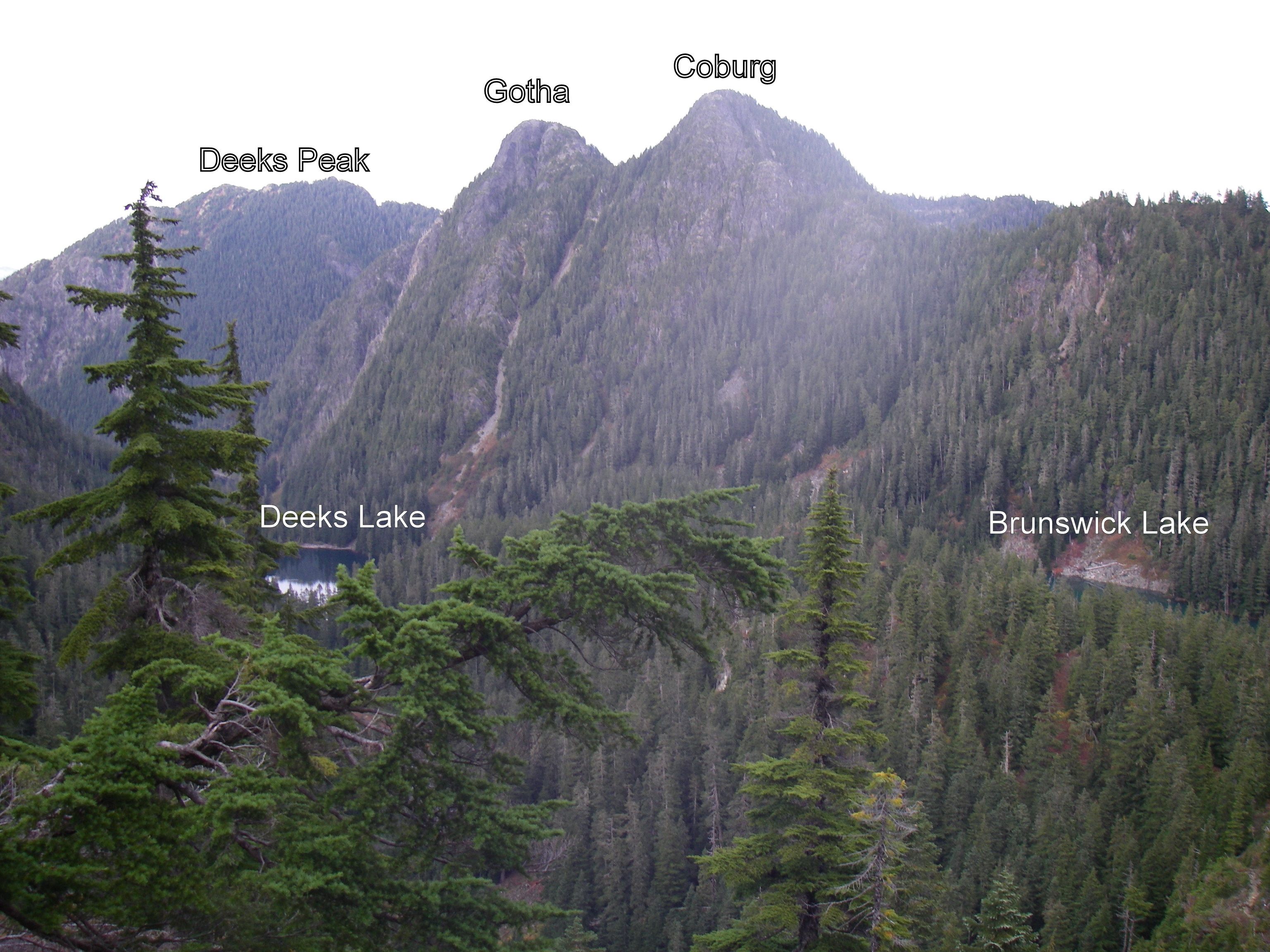
e.g.2 the proper peak of Gotha is the south peak, which is a semi-hair-raising traverse above a semi-sheer drop into Deaks Lakes way below; attaining the northern peak, with nearly identical height, will get you a point.
Resources and hyperlinks
103 = Bryceland & Macaree, 103 Hikes in Southwest British Columbia
MG = Matt Gunn, Scrambles in Southwest British Columbia
DH = Dawn Hanna, Best Hikes and Walks of Southwestern British Columbia
12= trip reports and maps
AB= peak photos
Note: the links to trip reports won't work unless your page is set to "50 comments per page" (the default setting)
Difficulty and Quality Rating {purple; in fancy brackets}
Difficulty: Hard; medium; easy
K = best hikes for kids
!!! = Dangerous: exposed or real risk of falling rock
!!!!!!!!! = Very dangerous; experienced mountaineers only
&& = trail at times faint or nonexistent; need route-finding skills
Quality: 1-5, with 1 being the best and 5 the worst
For a guided tour of the Bagger Peaks on Google Earth please click download the file attached below and open with Google Earth (and try the 3D flight simulator option under "tools"!)
For a full size Bagger map click on the image below:
Map by David Crerar; kindly and capably updated by Richard Macdonald
You could possibly do an Artaban/Burt's loop. The trail on the north side down Artaban is a bit steeper and overgrown with ferns, a bit hard to see your footing though. The trail on Burt's was good but it's bushwack for the last couple hundred meters to the peak.
I'm also not sure how late you'd be able to get a water taxi back on that side but you could abort on the way to Burt's and have a reasonably quick trip back on the lower elevation trail back from Brigade Bay to Halkett Bay/Fircom was faily easy and nice when I took it last year.
Also, I sort of think there should be a star for baby bags. Next year perhaps?
Bagged my first peak of the season today while joining one of the knee knacker training runs.
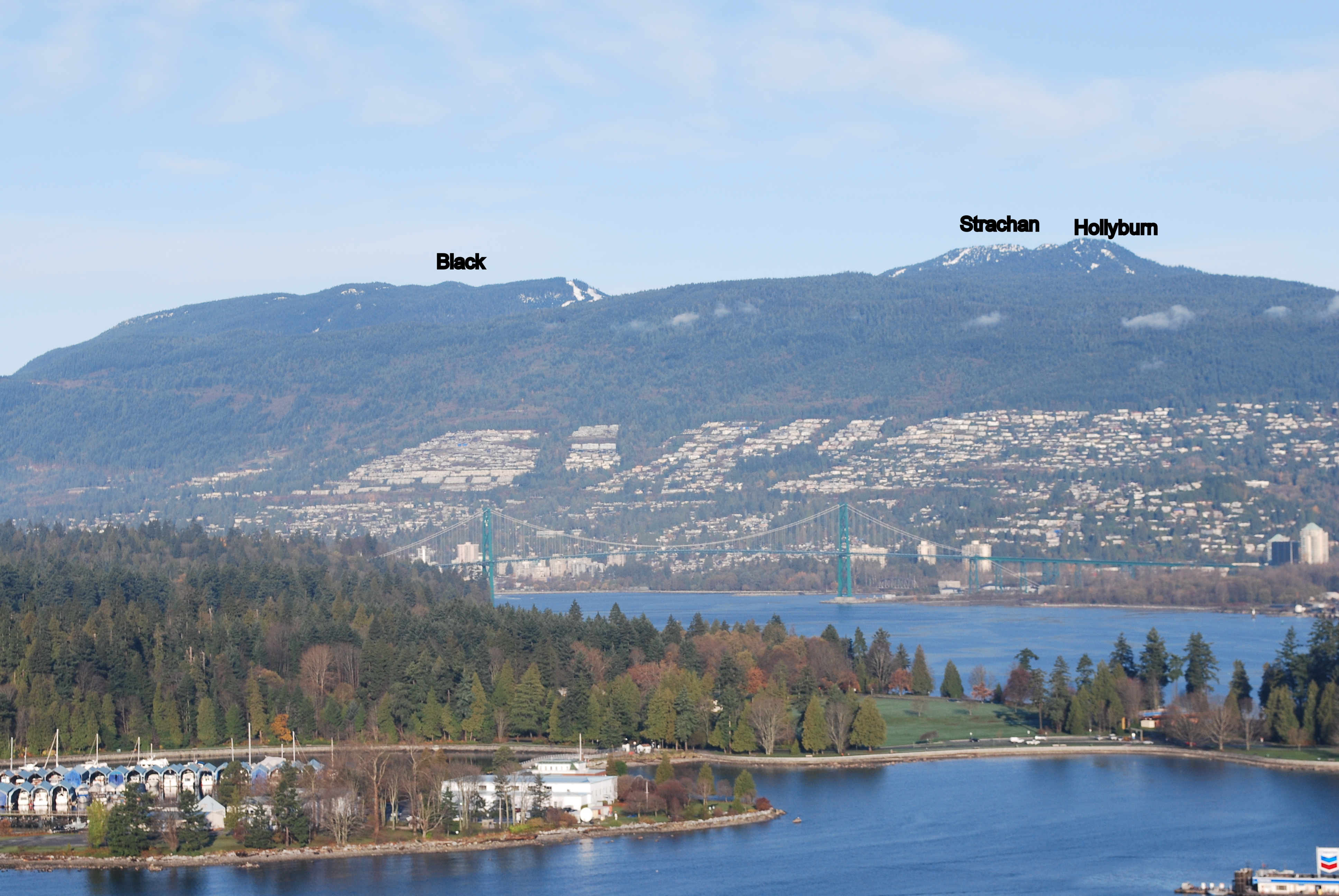
While most runners cut through towards Black Mountain I continued up the slope to the top of Hollyburn Peak. A bit of an icy scramble, but overall very rewarding with awesome views from the top.
One down, lots to go.
Bagged my first peak of the season today while joining one of the knee knacker training runs.
While most runners cut through towards Black Mountain I continued up the slope to the top of Hollyburn Peak. A bit of an icy scramble, but overall very rewarding with awesome views from the top.
One down, lots to go.
Note: I am screening participants for this trip so don't be intimidated by the wait list.
This is one of the longer trips and requires an ability to maintain a good pace for 12 hours and own lightweight bivvy gear. We will be returning on the first ferry Sunday morning. More details on the signup page.
Did Bowen Island yesterday with Angela and Glen. We met at the Ferry terminal at 7:45 in time to catch the 8:00am sailing. I cycled from/to home for the added green challenge (60km round trip). Weather was mostly clear with some cloudy periods. Saw lots of islanders coming into town on their daily commute to work. Cycled to the Gardner trailhead, then took the Skid trail over the top of the South summit and on to the helipad of the north summit for our first break. There is a lot of blowdown on the summit ridge. Noticed, for the first time, a small marker in the summit stone of the South summit. Headed down the north side trail back to the backs.
Gardner - South Summit Marker
Gardner - North Summit Helipad
I cycled back down to Snug Cove for the water bad and then over to Collins with Angela and Glen. It took a bit of GPSing to find the true summit net and then back down to Snug Cove for another water bag.
Collins - Summit Fishing Net
Angela waited here while Glen and myself cycled over to Apodaca for peak #3. Found the summit cairn ski pole along with a dear carcasse nearby that didn't make the return journey. We caught the 5:15 sailing back to Horseshoe Bay.
I took the day off work today and, with Jess, bagged South Lynn (SLY) and Lynn (LYN) Peaks today. The going was easy to the lookout just before SLY with no snow or deadfall to deal with. That changed immediately north of the lookout. Significant deadfall made the trail to SLY difficult to find resulting in much wandering about trying to find the trail flagging. There was some patchy snow at this point also but it wasn't an issue. Eventually, we found the trail flags (keep to the centre or slightly left on the ridge to find the markings). After the initial deadfall it cleared up fairly well to the peak.
From SLY to LYN the trail was again often difficult to find due to deadfall everywhere. Many of the trail flags are actually lying on the ground -- not particularly useful for spotting from a distance but still good for reassurance that we were still on (or near) the trail. Still only a few patches of snow. We eventually made it to Lynn Peak but it took a lot longer than planned ~2.5 hrs due to the difficulty with finding the trail.
Neither of us were really keen on going back via SLY so we opted to continue on to Hydraulic and take it down. There was a lot more snow north of Lynn Peak and that and the slimy rocks made the travel a bit sketchy at times. ~30 minutes got us to the Hydraulic junction. The South Needle looked tempting (to me, at least) but we'd already taken more time than planned to this point and, besides, South Needle isn't one of the peaks in the open for early bagging list.
Tons of deadfall heading down Hydraulic for the first 15 minutes or so but then it cleared up into just the usual exceptionally steep and slippery down. Somebody has been up this Spring and put up new flagging all the way along Hydraulic so it's pretty easy to follow right now -- even with the deadfall. 45 minutes of quad-crunching down got us back to the Seymour Valley Trailway -- sped up significantly for the last 10 minutes or so as Jess thought she heard some growling while I was futzing around taking photos of a waterfall and she took off like a shot!
Easy 7 km or so back to Lynn Headwaters along the Trailway and cutting through the trails by Rice Lake.
Great day for bagging!
Oh! Forgot to mention we also found a couple of geocaches -- one at the top of Hydraulic (which I'd done before) and one randomly along the Seymour Valley Trailway (I knew there were tons of them along the Trailway but didn't record any positions -- just looked in a spot the ought to have a cache and it did).
After a couple of weather delays I was finally able to launch my 2013 season on Victoria Day Monday May 20. Left Porteau at 8:30 for Anvil. Paddled across in the packraft with a calm Sound and overcast skies. There was a party camped at the landing spot that had done it as an overnight trip. The route was well flagged with pink ribbon. It heads immediately west uphill from the landing spot. There are a couple of tricky spots where it is easy to lose so familiarity definitely helped. It intersects with the trail from the Bible camp on the south side at marker 15 which is the col between the 2 high points of the island. The trail works its way around to the north side of the summit rock where there is communications equipment and a helicopter landing pad. There were 1' waves in the Sound on the return journey which was completed at Porteau at 3:10.
Paddling time to Anvil: 1:20
Time to top of Leading: 1:34
Time back to East Bay: 1:27
Paddling time to Porteau: 1:17
Total moving time: 5:38
Total time with breaks, setup, and transitions: 7:30
Shortest crossing distance: 5.1km
Went scoping out the Vancouver 100 course today and bagged Black in the process. Still enough snow to make the return trip down the ski hill a fast, fun, glissading option.
Anyone have a recommended GPS receiver for our bagging (and geo-caching) adventures? I have a Garmin eTrex Legend but it's nearing end-of-life and is quite dated, technology-wise, I'm sure. I've been comparing the Garmin GPSMAP 62 and Garmin eTrex 30 GPS. The former seems to have an additional interface is a bit more expensive and no barometric altimeter. The latter is lighter, has an SD card slot, barometric altimeter and electronic compass but is a bit cheaper so I'm wondering what key point I'm missing. Anyone know?
I wouldn't buy a dedicated GPS anymore. I find their displays less than satisfactory for displaying maps. I would recommend a Samsung Galaxy phone / tablet /media player. The bigger the screen the better. Any android device will do and I would use osmand as the mapping software. The better devices will support a removable micro-sd card as well as have interchangeable battery compartments. Osmand is a vector renderer that supports free full offline maps that are available for the entire globe. The OSM data it supports is very complete regarding the trails and routes required to do the Bagger Challenge. You can use osmand to do track logging but I use a separate app called gpslogger which runs in the background and is less battery intensive. I have the entire mapset for Southern BC loaded onto the device's micro-sd card including contours and it only takes 1GB of storage. I use the Samsung Galaxy Player 5.
The current all in one state of the art device is the Samsung Galaxy S4.
It generally depends on the age of the device. Garmin will improve receivers sometimes without changing model numbers. The external antena on the GPS62 is bound to make it more sensitive although I've been pleasantly surprised by the sensitivity of the phones. With all GPSs you have to pay attention to whether or not you have a good signal. They will often guestimate in poor conditions and get it wrong in the process.
Jess and I (with Sierra on back) kicked off our 2013 Bagger season with a bag of Mt. Gardner (GAR) on Bowen Island today. What a fantastic day! Beautiful summer-like weather. There's a lot of blowdown on the North Summit trail which made things a bit challenging at times with Sierra on the back but it was manageable nonetheless. The blowdown actually pushed us off track for the last big climb to the peak which made for an interesting ascent up a very steep route north of the correct trail but it topped out in approximately the right place. Near-tragedy ensued as somewhere in the last 1.5 km Sierra's teddy went AWOL (fortunately, we found him making a run for it only about 50m on the way back from the heli-pad -- before getting to the giant green penis). Even with Sierra on back, it was less than 1.5 hrs from the trailhead to the heli-pad. It took another 15 minutes to find the south (real) summit -- the challenging part being to find the trail frequently buried under several layers of deadfall (and negotiating around/through said deadfall).
Please mark both Jess and I down for GAR. Also, this was my first bag of this peak so that's one off my remaining all-time list.
Today I went from Cleveland dam up to the top of Hollyburn. Snowy and slippy and warm up there, I met a couple late season cross country skiers but had the peak to myself.
The Hollyburn Chute was a bit of a mess near the top, postholey with lots of downed trees.
Woke up early yesterday and was feeling ambitious. Decided on a bike and hike of Fromme from my place in Vancouver.
Stopped at Lynnwood Marina, then headed up Lillooet, which was pleasant, and Mountain Hwy, which was not so pleasant.
Stashed my bike and did the section of per gynt that links up Mountain Highway, which I wouldn't recommend. Hardpacked snow, but there was so much deadfall that travel was an issue.
Microspikes are a must.
Joined up with Bill's Trail after reaching Mountain highway again. Note: This is directly across the street from Per Gynt, some online reports mention people not finding it. This trail was in much better shape. Very hardpacked snow, and lots of room between the trees to choose directions between markers. Trail gets moderately steep on the last leg towards the summit, and I lost markers for a few hundred meters but just kept pushing upwards.
From the peak I took a marked trail back down a small gully, to the south west, and back to Mountain highway much faster than Bill's Trail. I didn't see any labels, but it's on my gps in Northwest Trails (http://www.switchbacks.com/nwtrails/). I wouldn't recommend heading up it right now, but it was nice heading down it. I think it might be upper Per Gynt?
Nice enough bike ride down, tried one of the easy blue/green mountain bike trails, which I think I'll avoid in the future.
Submitted by Ean Jackson on 30 April, 2013 - 21:10.
Woop woop!
Jose Rinas, Anna Gruen and Ean Jackson done done Hollyburn Mountain. Exhilarating descent on snowshoes. First time on snowshoes for Germans Anna and Jose.
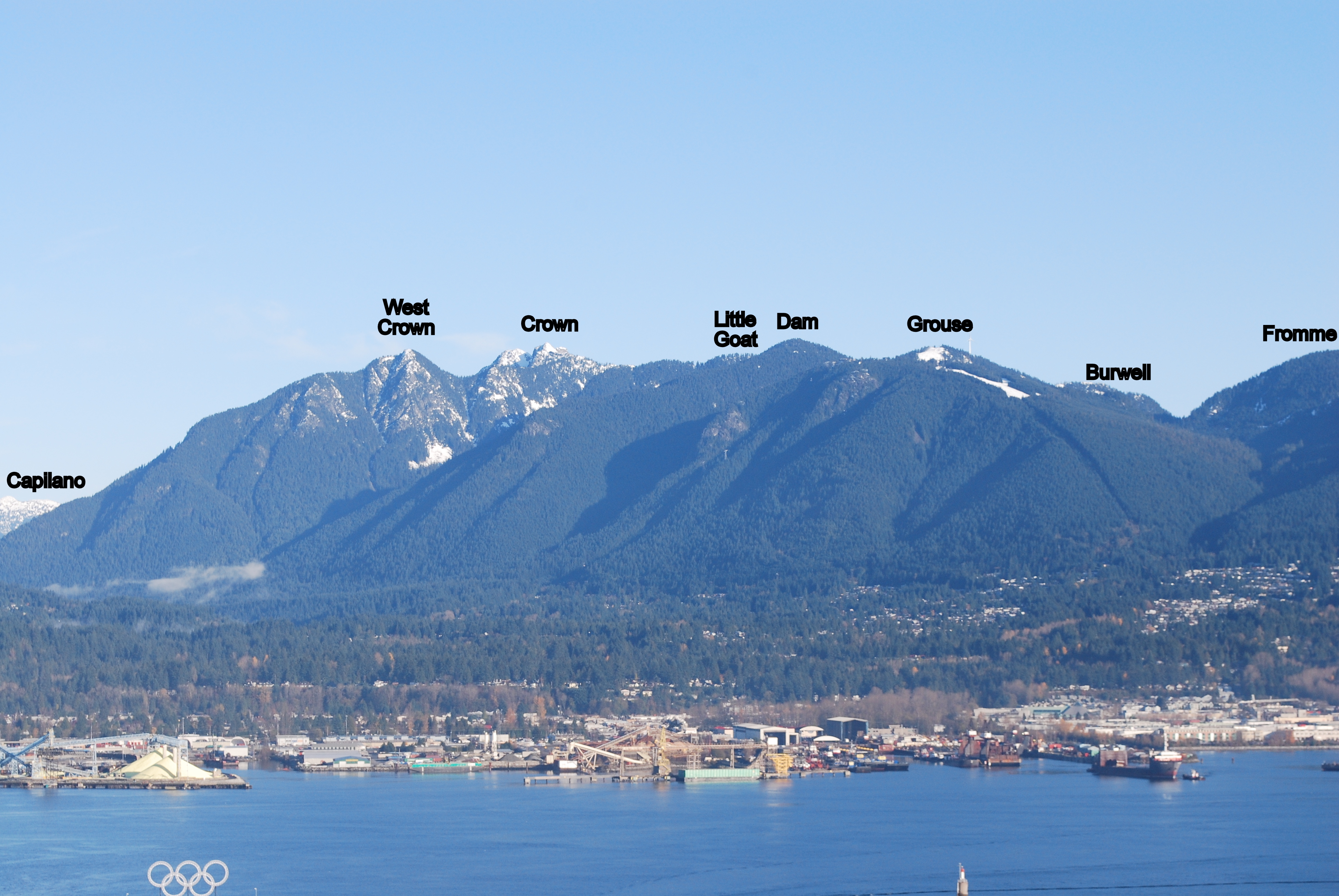
Today was a nice day to begin the 2013 Bagging exploits. It started with a slog up the BCMC, followed by another slog up to the top of Dam Mountain. Although everything was covered in snow, it was boiling hot up there. A real shorts and t-shirt kind of day.
I wanted to go down the road, but after criss-crossing ski hills and dodging the odd late season, hookey playing snowboarder and still not finding the start of the Mountain Highway, I soon gave up and blasted back down BCMC instead.
Quick little trip up De Pencier Bluffs and Suicide Bluffs with Nate. Nothing too exciting to report.
We took the main trail up and around brockton point. Had to skirt inside the marked run area for a bit to avoid the steep north side. One more weekend and that won't be a concern with seymour closing.
Been up De Pencier Bluffs once before and got fooled by that first hump, this time we skirted around the south side of it.
With all the trips I've taken up Dog Mountain, Suicide Bluffs was new. Fun little trail, will certainly be visiting it again. We avoided the first bluff on this trail as well, at least the first major looking one, and hit the second higher one before heading down to the NSSR Hut and then following the cut down to First Lake and back via the Dog Mountain trail.
Went up with a group of friends (Nate, James, Yves) to Leading Peak this Sunday (April 7).
Took Kayaks from Porteau Cove and took the rough trail to the east. Big props to anyone who has helped flag that route. It is very steep in sections, expect to be be on all fours and getting dirty. There are also a lot of loose rocks waiting to come down.
A few points of interest.
N49.53220 W123.29306 Cove - Trail starts just west of the big no tresspassing sign.
N49.53328 W123.29840 A cliff-face / rocks that you can hear water rushing under. The creek that comes out near the cove is mostly underground.
N49.53416 W123.30346 Cave - Just off the flagged route we came across a verticale fracture/clave that was a few feet across and of unknown depth.
N49.53749 W123.30647 Peak - Great vertical drops, will certainly try to revisit on a clearer day.
Weather wasn't the greatest, but we still had an amazing day. The ceiling was low and we were almost entirely in the clouds while on the peak. Had high tide on the way back and howe sound was amazingly still, it felt like we were on a lake. Saw porpoises off the North East end of the island.
Submitted by David Crerar on 4 April, 2013 - 06:10.
Bagging and geocaching go together like peanut butter and jelly.
Geocaching.com reveals there to be geocaches on a good percentage of the peak routes (on website map, scroll maps to North Shore, or click compass icon in top left of map to have the maps zoom in to the area near your computer).
There is an amazing geocache app at the iTunes store, produced by the same folks.
Ambitious baggers could leave a trail of caches on all routes and peaks, and register them at geocaching.com, for perpetual fame and glory.
An enormously fun activity with kids: you can have an Easter egg hunt year-round.
I've been bagging peaks for a while now and coming across CFA. Decided to take the plung this year.
Gave my bike a once over last night, which was a good thing, had some issues with my cogs, unfortunately it was a little too late to pick up parts so I ended up borrowing a bike from my buddy Nate.
Started out near Hastings and Boundary, up and over the Iron Workers and down to the docks at Lynnwood Marina then up to Lynn Headwaters to meet up with some friends, Nate, James and May, to tackle the trail. Certainly not my favorite trail, that rocky creek bed is pretty bad, but it was the first peak I ever bagged, so it seems particularly fitting that I start the challenge from here.
Snow started around 700 Meters, Micro-spikes were a huge boon. Left the group at the viewpoint to go bag the true peak. Snow was fairly well consolidated up there, was sinking around 4 inches with the occasional knee deep post-hole.
Was pretty neat being able to see my starting point, The Iron Workers, from the view point. All in all a very good day.
Also, I tried to update the KLM file with the peaks for this year's challenge. The current photo is still showing watershed peaks. Perhaps some of the more experienced members could give it a once over?
Submitted by Craig Moore on 1 April, 2013 - 19:58.
On a fantastic day full of sunshine and blue skies, Team Dodgy (Carolyn, Neil, Dave, Craig) completed their first Bags of the Season. Mark us down for two somewhat heinous bushwacks of Bowen, COL and APO. Both biking and hiking were heavily involved as well as some refreshments at the pub before heading home on the 5:30 pm ferry. And take note that both peaks were waterbags with a stroll to the beach at Cates Bay after COL.
Submitted by Ean Jackson on 18 January, 2013 - 09:02.
I recently learned something that I believe many peak baggers will be interested in. Read on if you like mysteries, Scotch whisky, and treasure hunts...
The Pots of Gold
There are at least four (4) bottles of fine Scotch whisky hidden in the area around Brunswick Lake on or near the Howe Sound Crest Trail. According to reliable sources, as of New Years Day 2013, all of the bottles were at least 2/3 full.
The Background
I heard this legend over a few beers and nachos at the Queen's Cross Pub in North Vancouver. It was the eve of the birthday of the Bard of Ayrshire (Robbie Burns.)The topic of discussion was things outdoors. It took a few pints, but the topic of conversation eventually arrived at the intersection of the North Shore Mountains and Scotch whisky. That's where it got interesting...
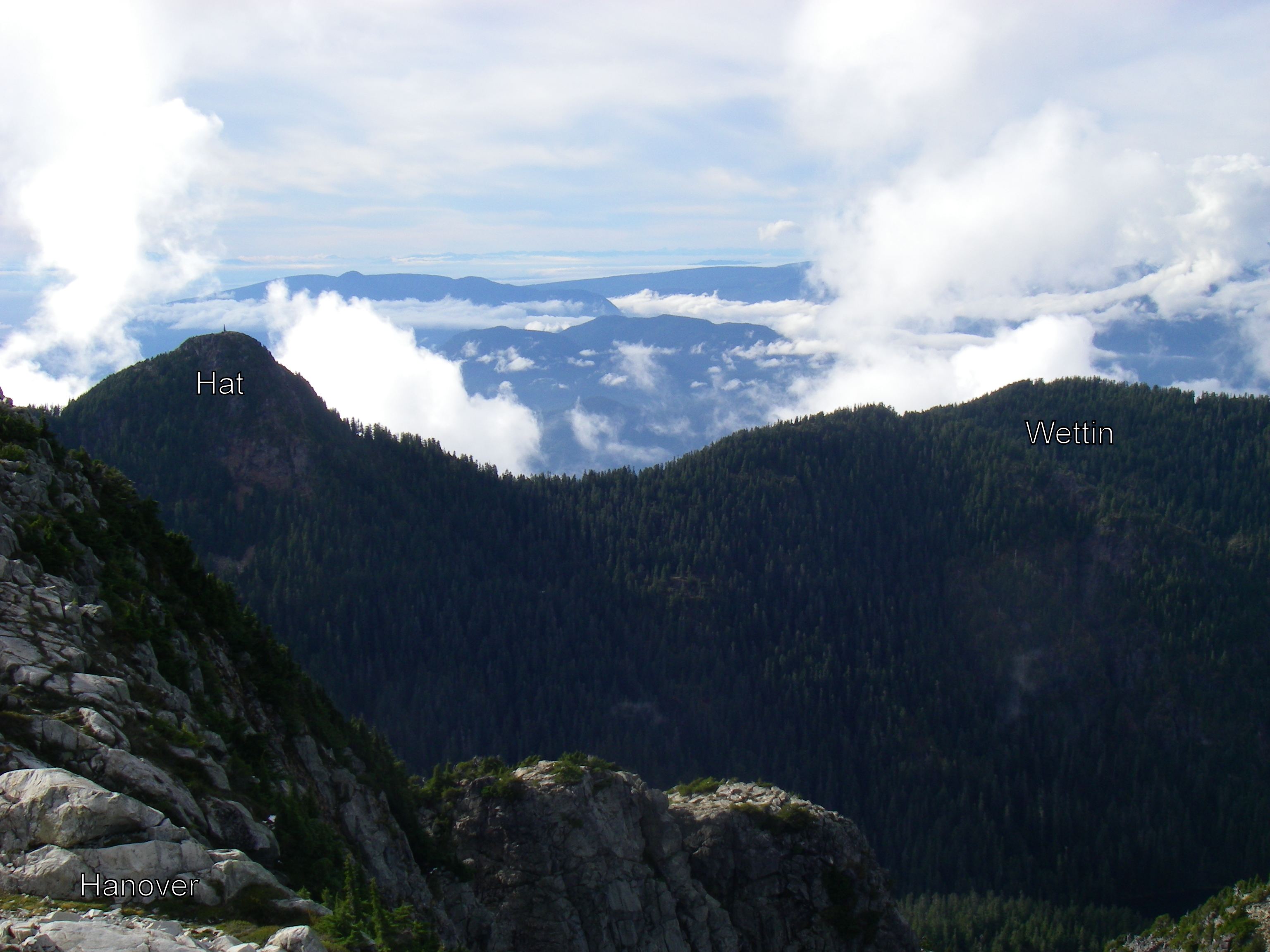
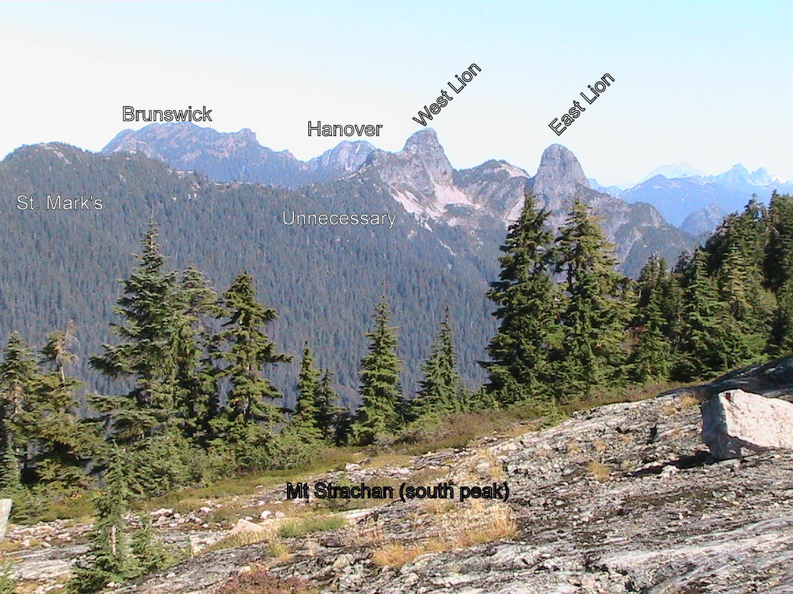
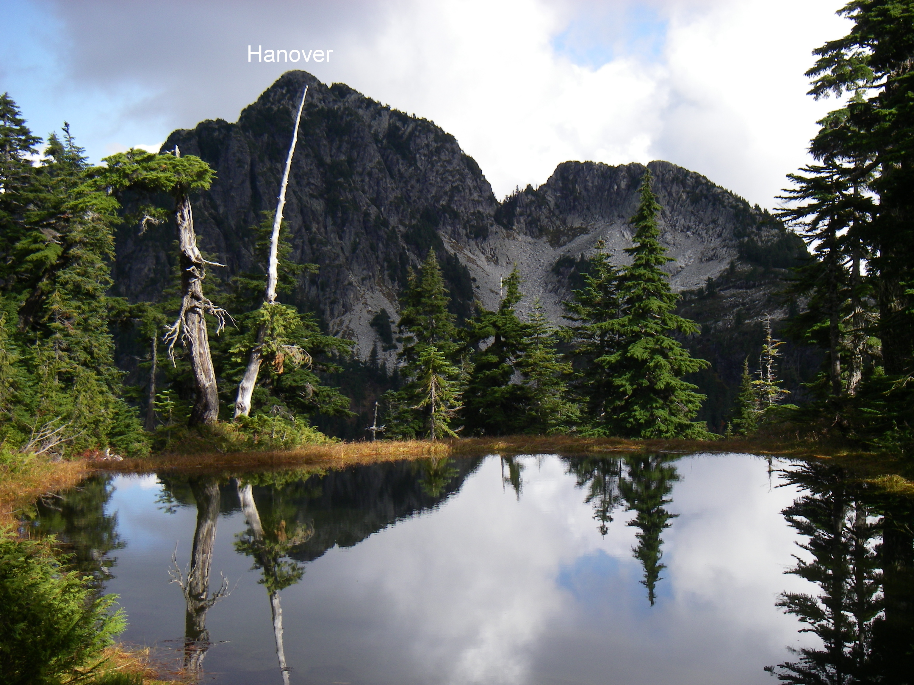
Alan, the source of the information, is someone with much experience in the North Shore mountains and an intimate familiarity of the area. The source claims he did not get his information from a leprechaun. This source furthermore claims to have personally witnessed these pots of gold at the end of the rainbow and may have even have been involved with placing them there. It gets better: there is apparently a plan to salt bottles on all the other peaks in that area: Capilano, Hat, Hannover, Lions, etc. and form a proper Howe Sound Whiskey Trail!
The Clues
This is all the information I could gather before last call...
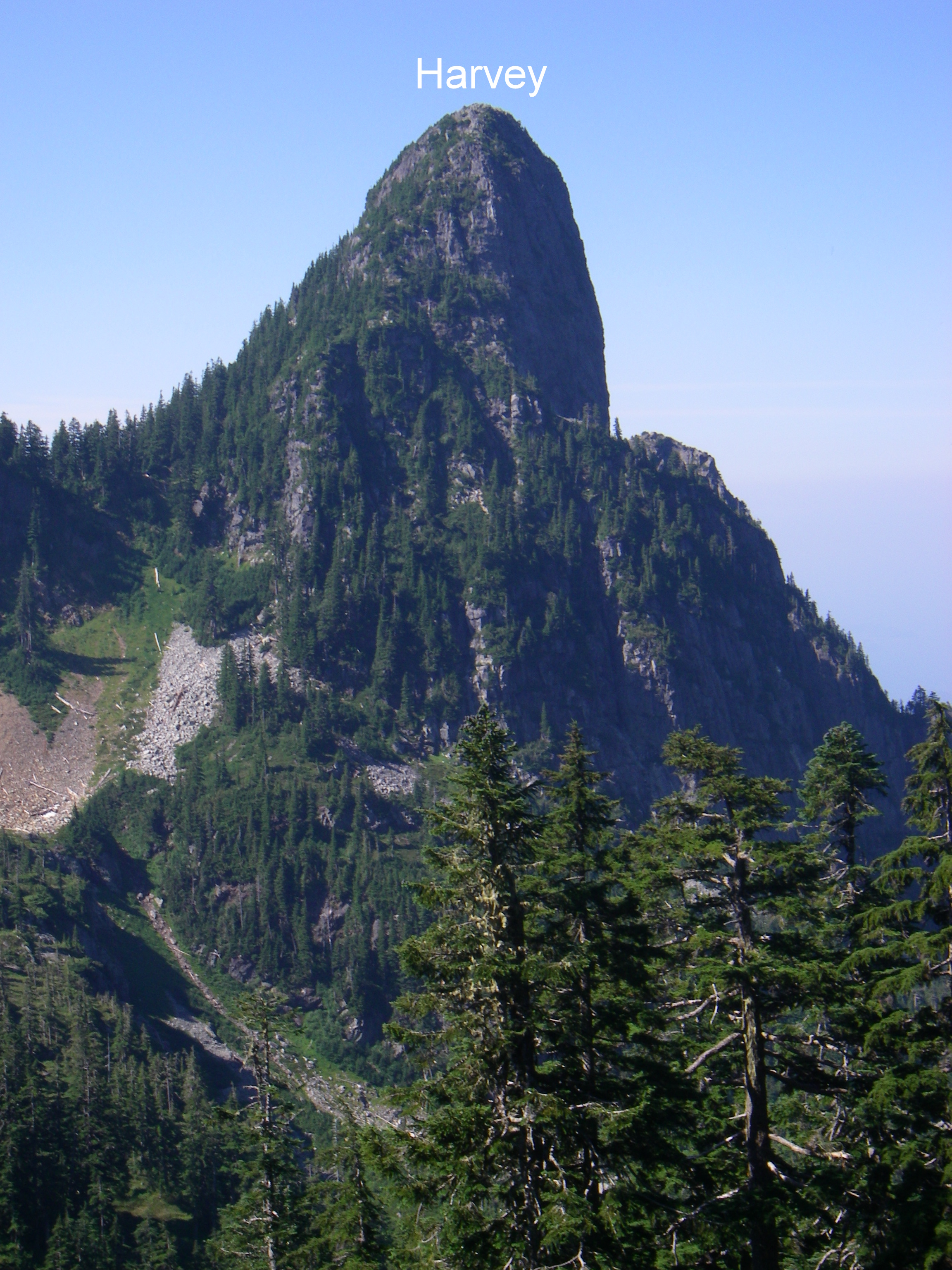
1. Mount Harvey
The location: In a stump just south of the summit.
The whisky: Bowmore.
The History: "My friend Bill came back from Nepal in 1994 with a bottle of "Mt. Everest" brand whiskey. That year I placed it in a hollow stump just south of the summit of Harvey. The following year I returned with Bill and found the bottle, but pretended I just found some whisky by accident. This bottle has since been replaced with Bowmore and guest book. The stump is immediately adjacent to the trail, on the right hand side as you ascend from the south, just at the foot of the last steep pitch to the summit.
2. Brunswick Peak
The location: On the summit proper, in a hole in the rock.
The whisky: Glen Livet.
The History: "Doug S. and I placed it on Brunswick in 2008. Doug commented at the car "I just brought a small bottle", assuming he meant a mickey. At the top he pulls out a 26. But you see, Doug is from Saskatchewan, where a standard bottle is a 40, and small bottles are 26's." If you are sitting on the one of the large timbers at the summit eating your lunch, look back along your footsteps towards Howe Sound and you will see an opening in the rock at ground level.
3. Magnesia Meadows
The location: In some duff within a small stand of trees to the south of the cabin.
The whisky: Most likely a Talisker.
The History: "Placed in 2010. That's the one when I just told Doug 'I left a message for you in Magnesia Meadows'." (Note: a small note in a crack in the emergency cabin provided specific instructions. 'Standing at the entrace to the hut, facing Howe Sound, you will notice a small grove of trees. Dig in the center of the duff accumulation to find the treasure.')
4. Brunswick Shelter
The location: near the shelter.
The whisky: Robbie Burns.
The History: "The most recent bottle was placed near the Brunswick shelter with my brother Dave in 2012. This is a curious whisky called "Robbie Burns". A bit gimmicky, but very smooth." This bottle is literally within 10 paces of the front entrance, just to the left of the path that leads down to the lake, hidden at ground level under a bent tree.
The Song
Alan has been so inspired by the beauty of this area that, like the Bard, he was driven to write poetry.
"I wrote a song called Crest Trail that describes the meaning of this area for me. Some of the lines are:
"On the crest of freedom
Our treasures can be found
Held high in the heavens
Stored safely in the ground
To taste a piece of grandeur
We enjoy our treasure in the sun
We'll return to empty spaces
When we run, run, run"
The "treasures" can be interpreted to represent the whiskey, but more importantly, it refers to the inherent natural wonder the area holds within."
Alan has recorded the whole song. I will try to upload it here for the enjoyment and inspiration of all.
The Protocol
Several of the bottles have a logbook hidden with them. Protocol requires that anyone who finds the treasure take only one sip, and logs the date and circumstances of their visit in the log book. In order to make the whisky last, it is highly recommended that if you find the treasure, you don't give away the exact location.
Perhaps anyone who finds a treasure might log their story and a photo here, too!


Comments
yes the best reference for BC
yes the best reference for BC you can find! my subscription is up at the end of the month
Gambier Peaks with kid on back
I've never done any of the Gambier Is peaks. Are any of them do-able with a kid on my back?
If not, does anyone have a status on the snow conditions up on de Pencier or Suicide?
Thanks
Possibly Artaban and Burt's
You could possibly do an Artaban/Burt's loop. The trail on the north side down Artaban is a bit steeper and overgrown with ferns, a bit hard to see your footing though. The trail on Burt's was good but it's bushwack for the last couple hundred meters to the peak.
I'm also not sure how late you'd be able to get a water taxi back on that side but you could abort on the way to Burt's and have a reasonably quick trip back on the lower elevation trail back from Brigade Bay to Halkett Bay/Fircom was faily easy and nice when I took it last year.
Also, I sort of think there should be a star for baby bags. Next year perhaps?
Thanks
Thanks for the tips!
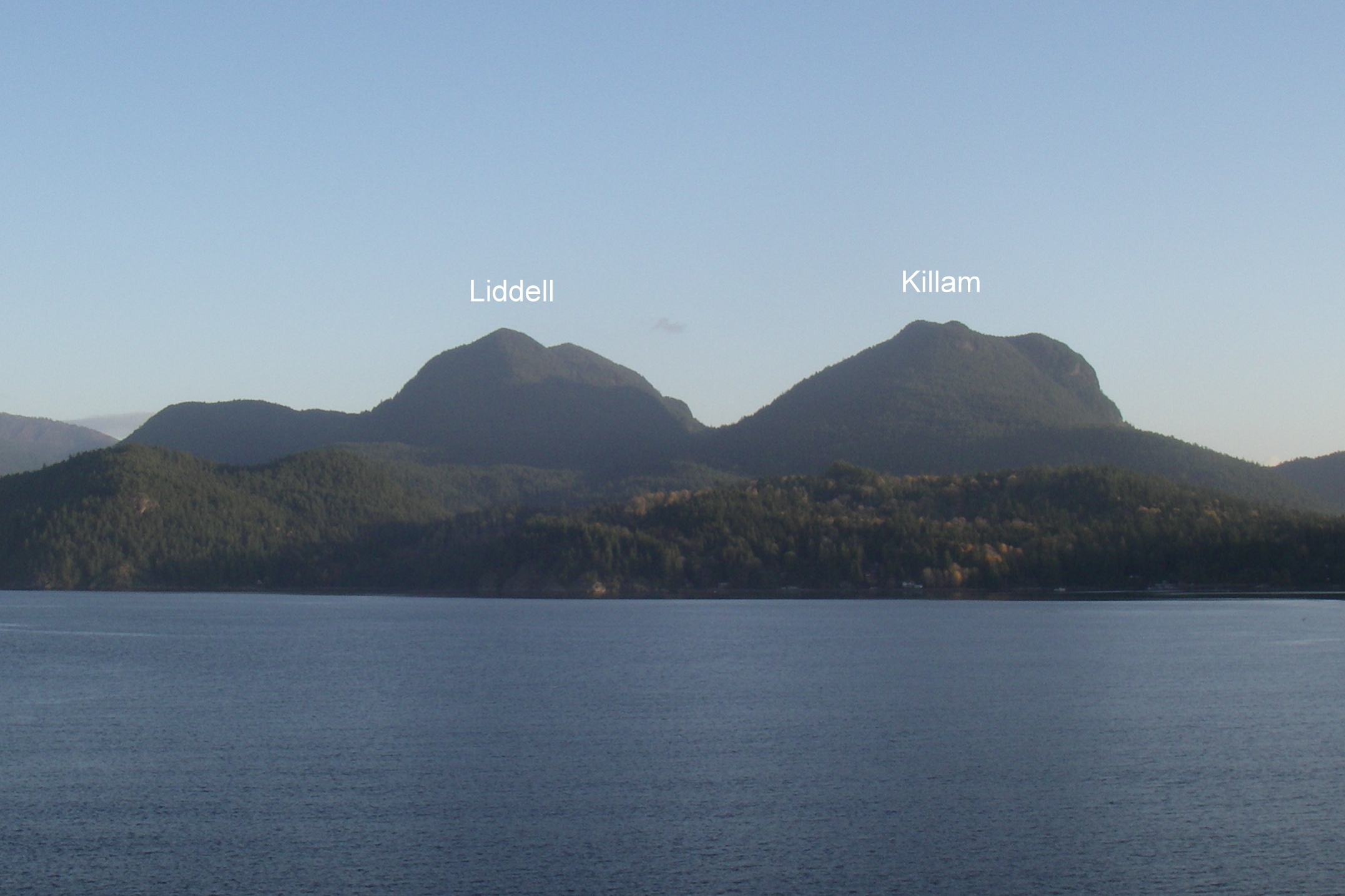
Artaban and Killam are doable.
Others too far.
Hollyburn Peak
Hollyburn Peak
Bagger Series 3 - Gambier - June 15th
Mts Artaban, Burts Bluff, Gambier, Liddell & Killam
I am organizing a long hike to bag all 5 summits of Gambier on June 15th.
We will be taking a water taxi from Horeseshoe Bay to Camp Fircom and returning via the Stormaway and Langdale ferries.
If interested sign up here: http://www.meetup.com/BC-Outdoor-Adventures/events/121208802
Note: I am screening participants for this trip so don't be intimidated by the wait list.
This is one of the longer trips and requires an ability to maintain a good pace for 12 hours and own lightweight bivvy gear. We will be returning on the first ferry Sunday morning. More details on the signup page.
Bowen Island (GAR*, BCO*, APO*)
Self Propelled
Did Bowen Island yesterday with Angela and Glen. We met at the Ferry terminal at 7:45 in time to catch the 8:00am sailing. I cycled from/to home for the added green challenge (60km round trip). Weather was mostly clear with some cloudy periods. Saw lots of islanders coming into town on their daily commute to work. Cycled to the Gardner trailhead, then took the Skid trail over the top of the South summit and on to the helipad of the north summit for our first break. There is a lot of blowdown on the summit ridge. Noticed, for the first time, a small marker in the summit stone of the South summit. Headed down the north side trail back to the backs.
Gardner - South Summit Marker
Gardner - North Summit Helipad
I cycled back down to Snug Cove for the water bad and then over to Collins with Angela and Glen. It took a bit of GPSing to find the true summit net and then back down to Snug Cove for another water bag.
Collins - Summit Fishing Net
Angela waited here while Glen and myself cycled over to Apodaca for peak #3. Found the summit cairn ski pole along with a dear carcasse nearby that didn't make the return journey. We caught the 5:15 sailing back to Horseshoe Bay.
Apodaca - Summit Ski Pole
Bill: (GAR*, BCO*, APO*)
Glen: (GAR*, BCO, APO*)
Angela: (GAR*, BCO*)
South Lynn (SLY) & Lynn (LYN) Peaks Bagged with Jess
I took the day off work today and, with Jess, bagged South Lynn (SLY) and Lynn (LYN) Peaks today. The going was easy to the lookout just before SLY with no snow or deadfall to deal with. That changed immediately north of the lookout. Significant deadfall made the trail to SLY difficult to find resulting in much wandering about trying to find the trail flagging. There was some patchy snow at this point also but it wasn't an issue. Eventually, we found the trail flags (keep to the centre or slightly left on the ridge to find the markings). After the initial deadfall it cleared up fairly well to the peak.
From SLY to LYN the trail was again often difficult to find due to deadfall everywhere. Many of the trail flags are actually lying on the ground -- not particularly useful for spotting from a distance but still good for reassurance that we were still on (or near) the trail. Still only a few patches of snow. We eventually made it to Lynn Peak but it took a lot longer than planned ~2.5 hrs due to the difficulty with finding the trail.
Neither of us were really keen on going back via SLY so we opted to continue on to Hydraulic and take it down. There was a lot more snow north of Lynn Peak and that and the slimy rocks made the travel a bit sketchy at times. ~30 minutes got us to the Hydraulic junction. The South Needle looked tempting (to me, at least) but we'd already taken more time than planned to this point and, besides, South Needle isn't one of the peaks in the open for early bagging list.
Tons of deadfall heading down Hydraulic for the first 15 minutes or so but then it cleared up into just the usual exceptionally steep and slippery down. Somebody has been up this Spring and put up new flagging all the way along Hydraulic so it's pretty easy to follow right now -- even with the deadfall. 45 minutes of quad-crunching down got us back to the Seymour Valley Trailway -- sped up significantly for the last 10 minutes or so as Jess thought she heard some growling while I was futzing around taking photos of a waterfall and she took off like a shot!
Easy 7 km or so back to Lynn Headwaters along the Trailway and cutting through the trails by Rice Lake.
Great day for bagging!
Oh! Forgot to mention we also found a couple of geocaches -- one at the top of Hydraulic (which I'd done before) and one randomly along the Seymour Valley Trailway (I knew there were tons of them along the Trailway but didn't record any positions -- just looked in a spot the ought to have a cache and it did).
GPS Track: http://connect.garmin.com/activity/317501367
All photos: http://www.flickr.com/photos/billdagg/sets/72157633635388267/
South Lynn Peak
Lynn Peak
Rice Lake
Reminder, Bowen Island Trip tomorrow
The weather is looking promising. :-)
I am organizing a bike 'n hike trip to Bowen Island tomorrow on Friday May 24th.
We will be taking the ferry from Horseshoe Bay to Snug Cove and cycling from there. You need a mountain bike for this one.
If interested sign up here: http://www.meetup.com/BC-Outdoor-Adventures/events/114251532/
Note: I am screening participants for this trip so don't be intimidated by the wait list.
Leading Peak, Anvil Island (LEA*)
After a couple of weather delays I was finally able to launch my 2013 season on Victoria Day Monday May 20. Left Porteau at 8:30 for Anvil. Paddled across in the packraft with a calm Sound and overcast skies. There was a party camped at the landing spot that had done it as an overnight trip. The route was well flagged with pink ribbon. It heads immediately west uphill from the landing spot. There are a couple of tricky spots where it is easy to lose so familiarity definitely helped. It intersects with the trail from the Bible camp on the south side at marker 15 which is the col between the 2 high points of the island. The trail works its way around to the north side of the summit rock where there is communications equipment and a helicopter landing pad. There were 1' waves in the Sound on the return journey which was completed at Porteau at 3:10.
Paddling time to Anvil: 1:20
Time to top of Leading: 1:34
Time back to East Bay: 1:27
Paddling time to Porteau: 1:17
Total moving time: 5:38
Total time with breaks, setup, and transitions: 7:30
Shortest crossing distance: 5.1km
Apologies
Black.
Went scoping out the Vancouver 100 course today and bagged Black in the process. Still enough snow to make the return trip down the ski hill a fast, fun, glissading option.
Handheld GPSr Recommendation
Anyone have a recommended GPS receiver for our bagging (and geo-caching) adventures? I have a Garmin eTrex Legend but it's nearing end-of-life and is quite dated, technology-wise, I'm sure. I've been comparing the Garmin GPSMAP 62 and Garmin eTrex 30 GPS. The former seems to have an additional interface is a bit more expensive and no barometric altimeter. The latter is lighter, has an SD card slot, barometric altimeter and electronic compass but is a bit cheaper so I'm wondering what key point I'm missing. Anyone know?
Thanks
gps
I wouldn't buy a dedicated GPS anymore. I find their displays less than satisfactory for displaying maps. I would recommend a Samsung Galaxy phone / tablet /media player. The bigger the screen the better. Any android device will do and I would use osmand as the mapping software. The better devices will support a removable micro-sd card as well as have interchangeable battery compartments. Osmand is a vector renderer that supports free full offline maps that are available for the entire globe. The OSM data it supports is very complete regarding the trails and routes required to do the Bagger Challenge. You can use osmand to do track logging but I use a separate app called gpslogger which runs in the background and is less battery intensive. I have the entire mapset for Southern BC loaded onto the device's micro-sd card including contours and it only takes 1GB of storage. I use the Samsung Galaxy Player 5.
The current all in one state of the art device is the Samsung Galaxy S4.
Thanks
Thanks Bill. Interesting idea. Are the receivers in the phones just as good those in the handhelds?
receivers
It generally depends on the age of the device. Garmin will improve receivers sometimes without changing model numbers. The external antena on the GPS62 is bound to make it more sensitive although I've been pleasantly surprised by the sensitivity of the phones. With all GPSs you have to pay attention to whether or not you have a good signal. They will often guestimate in poor conditions and get it wrong in the process.
Diaper Bag of Gardner (GAR) with Jess (& Sierra)
Jess and I (with Sierra on back) kicked off our 2013 Bagger season with a bag of Mt. Gardner (GAR) on Bowen Island today. What a fantastic day! Beautiful summer-like weather. There's a lot of blowdown on the North Summit trail which made things a bit challenging at times with Sierra on the back but it was manageable nonetheless. The blowdown actually pushed us off track for the last big climb to the peak which made for an interesting ascent up a very steep route north of the correct trail but it topped out in approximately the right place. Near-tragedy ensued as somewhere in the last 1.5 km Sierra's teddy went AWOL (fortunately, we found him making a run for it only about 50m on the way back from the heli-pad -- before getting to the giant green penis). Even with Sierra on back, it was less than 1.5 hrs from the trailhead to the heli-pad. It took another 15 minutes to find the south (real) summit -- the challenging part being to find the trail frequently buried under several layers of deadfall (and negotiating around/through said deadfall).
Please mark both Jess and I down for GAR. Also, this was my first bag of this peak so that's one off my remaining all-time list.
Cheers.
Here we are at the (boring) south peak ...
Sierra and I at the fantastic north peak ...
I have Hollyburned.
Today I went from Cleveland dam up to the top of Hollyburn. Snowy and slippy and warm up there, I met a couple late season cross country skiers but had the peak to myself.
The Hollyburn Chute was a bit of a mess near the top, postholey with lots of downed trees.
FRO* Waterbag
Woke up early yesterday and was feeling ambitious. Decided on a bike and hike of Fromme from my place in Vancouver.
Stopped at Lynnwood Marina, then headed up Lillooet, which was pleasant, and Mountain Hwy, which was not so pleasant.
Stashed my bike and did the section of per gynt that links up Mountain Highway, which I wouldn't recommend. Hardpacked snow, but there was so much deadfall that travel was an issue.
Microspikes are a must.
Joined up with Bill's Trail after reaching Mountain highway again. Note: This is directly across the street from Per Gynt, some online reports mention people not finding it. This trail was in much better shape. Very hardpacked snow, and lots of room between the trees to choose directions between markers. Trail gets moderately steep on the last leg towards the summit, and I lost markers for a few hundred meters but just kept pushing upwards.
From the peak I took a marked trail back down a small gully, to the south west, and back to Mountain highway much faster than Bill's Trail. I didn't see any labels, but it's on my gps in Northwest Trails (http://www.switchbacks.com/nwtrails/). I wouldn't recommend heading up it right now, but it was nice heading down it. I think it might be upper Per Gynt?
Nice enough bike ride down, tried one of the easy blue/green mountain bike trails, which I think I'll avoid in the future.
HOL Snowshoe Bag
Woop woop!
Jose Rinas, Anna Gruen and Ean Jackson done done Hollyburn Mountain. Exhilarating descent on snowshoes. First time on snowshoes for Germans Anna and Jose.
GRO Ski Bag
Erik Jackson and Ean Jackson claim Grouse Peak (GRO). Confession: we had some mechanical help =:-)
Sounds like Maurer
http://24n24.blogspot.ca/p/24n24-epic4epic-endeavor.html
more like Jackson
I like to sleep when it gets dark!
One down, fifty-seven to go!
Today was a nice day to begin the 2013 Bagging exploits. It started with a slog up the BCMC, followed by another slog up to the top of Dam Mountain. Although everything was covered in snow, it was boiling hot up there. A real shorts and t-shirt kind of day.
I wanted to go down the road, but after criss-crossing ski hills and dodging the odd late season, hookey playing snowboarder and still not finding the start of the Mountain Highway, I soon gave up and blasted back down BCMC instead.
DAM Dam Mountain (1349m) (P: 99m)
DEP, SUI - April 21
Quick little trip up De Pencier Bluffs and Suicide Bluffs with Nate. Nothing too exciting to report.
We took the main trail up and around brockton point. Had to skirt inside the marked run area for a bit to avoid the steep north side. One more weekend and that won't be a concern with seymour closing.
Been up De Pencier Bluffs once before and got fooled by that first hump, this time we skirted around the south side of it.
With all the trips I've taken up Dog Mountain, Suicide Bluffs was new. Fun little trail, will certainly be visiting it again. We avoided the first bluff on this trail as well, at least the first major looking one, and hit the second higher one before heading down to the NSSR Hut and then following the cut down to First Lake and back via the Dog Mountain trail.
Mt Gardner, Collins, Apodaca, Bowen Island - May 24th
I am organizing a bike 'n hike trip to Bowen Island on Friday May 24th.
We will be taking the ferry from Horseshoe Bay to Snug Cove and cycling from there. You need a mountain bike for this one.
If interested sign up here: http://www.meetup.com/BC-Outdoor-Adventures/events/114251532/
Note: I am screening participants for this trip so don't be intimidated by the wait list.
Leading Peak, Anvil Island - May 18th
I am organizing a boat 'n hike trip to Leading Peak on Saturday May 18th.
We will be approaching from Porteau Cove and East Creek. You need a boat for this one.
If interested sign up here: http://www.meetup.com/BC-Outdoor-Adventures/events/114250282/
Note: I am screening participants for this trip so don't be intimidated by the wait list.
NEW FOR 2013: GEOCACHE BAGS
Leading Peak - East Approach
Went up with a group of friends (Nate, James, Yves) to Leading Peak this Sunday (April 7).
Took Kayaks from Porteau Cove and took the rough trail to the east. Big props to anyone who has helped flag that route. It is very steep in sections, expect to be be on all fours and getting dirty. There are also a lot of loose rocks waiting to come down.
A few points of interest.
N49.53220 W123.29306 Cove - Trail starts just west of the big no tresspassing sign.
N49.53328 W123.29840 A cliff-face / rocks that you can hear water rushing under. The creek that comes out near the cove is mostly underground.
N49.53416 W123.30346 Cave - Just off the flagged route we came across a verticale fracture/clave that was a few feet across and of unknown depth.
N49.53749 W123.30647 Peak - Great vertical drops, will certainly try to revisit on a clearer day.
Weather wasn't the greatest, but we still had an amazing day. The ceiling was low and we were almost entirely in the clouds while on the peak. Had high tide on the way back and howe sound was amazingly still, it felt like we were on a lake. Saw porpoises off the North East end of the island.
Peak Bagger file *.kmz file converted to gpx?
Does anyone have or know how to convert the amazing Google Earth kmz Peak Bagger file to a Garmin usable gpx file (or have one to share)?
I'm not too familar with how to do this so any help would be appreciated!
Cheers!
Mike
I converted files with GPS
I converted files with GPS Babel before: http://www.gpsvisualizer.com/gpsbabel/
Geocachebagging
Geocaching.com reveals there to be geocaches on a good percentage of the peak routes (on website map, scroll maps to North Shore, or click compass icon in top left of map to have the maps zoom in to the area near your computer).
There is an amazing geocache app at the iTunes store, produced by the same folks.
Ambitious baggers could leave a trail of caches on all routes and peaks, and register them at geocaching.com, for perpetual fame and glory.
An enormously fun activity with kids: you can have an Easter egg hunt year-round.
First of Many - South Lynn Peak Waterbag
I've been bagging peaks for a while now and coming across CFA. Decided to take the plung this year.
Gave my bike a once over last night, which was a good thing, had some issues with my cogs, unfortunately it was a little too late to pick up parts so I ended up borrowing a bike from my buddy Nate.
Started out near Hastings and Boundary, up and over the Iron Workers and down to the docks at Lynnwood Marina then up to Lynn Headwaters to meet up with some friends, Nate, James and May, to tackle the trail. Certainly not my favorite trail, that rocky creek bed is pretty bad, but it was the first peak I ever bagged, so it seems particularly fitting that I start the challenge from here.
Snow started around 700 Meters, Micro-spikes were a huge boon. Left the group at the viewpoint to go bag the true peak. Snow was fairly well consolidated up there, was sinking around 4 inches with the occasional knee deep post-hole.
Was pretty neat being able to see my starting point, The Iron Workers, from the view point. All in all a very good day.
Also, I tried to update the KLM file with the peaks for this year's challenge. The current photo is still showing watershed peaks. Perhaps some of the more experienced members could give it a once over?
https://docs.google.com/file/d/0B8Wyje4WyXJbR0FselM2cHJrdkU/edit?usp=sharing
Great job on the map!
This indicates that you may have ambitions! Welcome and happy bagging.
Thanks David. Certainly
Thanks David. Certainly motivated right now, will see how it progresses.
First of the Season
On a fantastic day full of sunshine and blue skies, Team Dodgy (Carolyn, Neil, Dave, Craig) completed their first Bags of the Season. Mark us down for two somewhat heinous bushwacks of Bowen, COL and APO. Both biking and hiking were heavily involved as well as some refreshments at the pub before heading home on the 5:30 pm ferry. And take note that both peaks were waterbags with a stroll to the beach at Cates Bay after COL.
COL?
Yes BCO
Sean is on the ball.
NORTH SHORE BAGGER CHALLENGE STARTS in 15 days
NORTH SHORE BAGGER CHALLENGE VIDEO
http://www.clubfatass.com/blog/david-crerar/north-shore-bagger-challenge...
The Legend of Brunswick Lake
I recently learned something that I believe many peak baggers will be interested in. Read on if you like mysteries, Scotch whisky, and treasure hunts...
The Pots of Gold
There are at least four (4) bottles of fine Scotch whisky hidden in the area around Brunswick Lake on or near the Howe Sound Crest Trail. According to reliable sources, as of New Years Day 2013, all of the bottles were at least 2/3 full.
The Background
I heard this legend over a few beers and nachos at the Queen's Cross Pub in North Vancouver. It was the eve of the birthday of the Bard of Ayrshire (Robbie Burns.) The topic of discussion was things outdoors. It took a few pints, but the topic of conversation eventually arrived at the intersection of the North Shore Mountains and Scotch whisky. That's where it got interesting...
Alan, the source of the information, is someone with much experience in the North Shore mountains and an intimate familiarity of the area. The source claims he did not get his information from a leprechaun. This source furthermore claims to have personally witnessed these pots of gold at the end of the rainbow and may have even have been involved with placing them there. It gets better: there is apparently a plan to salt bottles on all the other peaks in that area: Capilano, Hat, Hannover, Lions, etc. and form a proper Howe Sound Whiskey Trail!
The Clues
This is all the information I could gather before last call...
1. Mount Harvey
The location: In a stump just south of the summit.
The whisky: Bowmore.
The History: "My friend Bill came back from Nepal in 1994 with a bottle of "Mt. Everest" brand whiskey. That year I placed it in a hollow stump just south of the summit of Harvey. The following year I returned with Bill and found the bottle, but pretended I just found some whisky by accident. This bottle has since been replaced with Bowmore and guest book. The stump is immediately adjacent to the trail, on the right hand side as you ascend from the south, just at the foot of the last steep pitch to the summit.
2. Brunswick Peak
The location: On the summit proper, in a hole in the rock.
The whisky: Glen Livet.
The History: "Doug S. and I placed it on Brunswick in 2008. Doug commented at the car "I just brought a small bottle", assuming he meant a mickey. At the top he pulls out a 26. But you see, Doug is from Saskatchewan, where a standard bottle is a 40, and small bottles are 26's." If you are sitting on the one of the large timbers at the summit eating your lunch, look back along your footsteps towards Howe Sound and you will see an opening in the rock at ground level.
3. Magnesia Meadows
The location: In some duff within a small stand of trees to the south of the cabin.
The whisky: Most likely a Talisker.
The History: "Placed in 2010. That's the one when I just told Doug 'I left a message for you in Magnesia Meadows'." (Note: a small note in a crack in the emergency cabin provided specific instructions. 'Standing at the entrace to the hut, facing Howe Sound, you will notice a small grove of trees. Dig in the center of the duff accumulation to find the treasure.')
4. Brunswick Shelter
The location: near the shelter.
The whisky: Robbie Burns.
The History: "The most recent bottle was placed near the Brunswick shelter with my brother Dave in 2012. This is a curious whisky called "Robbie Burns". A bit gimmicky, but very smooth." This bottle is literally within 10 paces of the front entrance, just to the left of the path that leads down to the lake, hidden at ground level under a bent tree.
The Song
Alan has been so inspired by the beauty of this area that, like the Bard, he was driven to write poetry.
"I wrote a song called Crest Trail that describes the meaning of this area for me. Some of the lines are:
"On the crest of freedom
Our treasures can be found
Held high in the heavens
Stored safely in the ground
To taste a piece of grandeur
We enjoy our treasure in the sun
We'll return to empty spaces
When we run, run, run"
The "treasures" can be interpreted to represent the whiskey, but more importantly, it refers to the inherent natural wonder the area holds within."
Alan has recorded the whole song. I will try to upload it here for the enjoyment and inspiration of all.
The Protocol
Several of the bottles have a logbook hidden with them. Protocol requires that anyone who finds the treasure take only one sip, and logs the date and circumstances of their visit in the log book. In order to make the whisky last, it is highly recommended that if you find the treasure, you don't give away the exact location.
Perhaps anyone who finds a treasure might log their story and a photo here, too!