Submitted by liza_f on 12 September, 2010 - 16:32.
headed up to bag Lynn Peak at 1:00 this afternoon, under the quasi-mistaken impresion that the rain was "tapering off" (it was, kind of, from certain angles, and of course not taking the tree rain into account) and that I would see whether South Needle could be gotten as well. Short answer - no SNE for this girl, not today. but at least I 1. got my ass off the couch and ran to the top of Lynn; 2. reminded myself why I would rather run in the rain in Vancouver than the snow in Calgary; 3. broke in my new trail shoes a little bit; and 4. scared the crap out of some hikers who were convinced they had the whole mountain to themselves. not bad for a rainy day and a wee little peak...
Submitted by David Crerar on 12 September, 2010 - 10:30.
Bagger champions in the canine and human categories, respectively, Tundra and Ken, just bagged the nastiest peak in the list: PER. Methinks that could mean only one thing...
Submitted by neil ambrose on 12 September, 2010 - 09:33.
Yesterday Neil and I bagged Grouse, Dam, Little Goat, Goat, Crown and West Crown. Views were limited due to the mist but it does help reduce any fear when you can't see the vertical drops. ;-)
Submitted by Sibylle on 12 September, 2010 - 08:38.
Dear Mr. Baggermeister,
I noticed that you awarded SEY to the Bald Guy from Missouri and limping Action Jackson. The softies actually turned around after reaching DePencier Bluffs because it drizzled on them No SEY for them yesterday.
Submitted by Craig Moore on 12 September, 2010 - 08:05.
In areas where signals are weak, phones tend to work harder to locate and make contact with cell towers, a function that drains their batteries, he said. By turning cellphones off, hikers can ensure they still have power in the event of an emergency.
This issue was highlighted again on Sunday when the team was called in to find a pair of hikers who had failed to return on time from an overnight hike to Cathedral Mountain west of Seymour Lake. As it turned out, the men had simply been delayed. They ran into rescuers on Lynn Headwaters trail.
The men in Sunday's incident were well equipped, but both of their cellphones had died. Had the phones been charged, the search might have been avoided, said Jones.
Submitted by Sibylle on 8 September, 2010 - 05:50.
Ahem, can you shed some light on this. Assuming it's Craig. Did he need rescue by Guy?
Speaking of cellphones...I am trying to get Ean to learn to text on his phone as texts apparently get out when voice can't. His call's from the HSCT to check in were all cut off.
Submitted by Craig Moore on 7 September, 2010 - 23:01.
but we're very thankful.
And speaking of phone calls, all Baggers beware of being out of cell phone range: turn your phone off to save battery life. Otherwise your phone(s) may get drained much faster than you expect.
Submitted by Ean Jackson on 8 September, 2010 - 09:12.
Details, bro! Trip report, por favor!!
I'm planning a similar expedition on the next sunny day. Looking for most efficient way to do a 3-bagger with Burwell, Colleseum and Cathedral. Figure a bike ride is in the mix... maybe through the Forbidden Forest.
Submitted by Killaine on 8 September, 2010 - 08:12.
I'll leave the story to Craig. On the subject of cell phones, while they may be helpful they also have major limitations (like dead batteries and no coverage). We've had a SPOT for a week and am a total convert. Definitely the way to go. It is cheap, tiny, and works everywhere. I think all baggers (or at least Ean and Craig :) should seriously consider a SPOT.
Submitted by neil ambrose on 6 September, 2010 - 18:15.
Today Neil, Wendy and I ventured out in the rain but were very sensible in the poor conditions and chose to bag Hollyburn, Strachan and Black. That's 6 for us this weekend...sleep well fellow baggers!!
Submitted by Ean Jackson on 7 September, 2010 - 08:03.
is just beyond CFA and HAT. It's a non-descript knob of a nothing peak... especially useless in the fog, as I experienced it on Sunday. I noticed that it was not on your list of peaks in the bag this year
Congrats on toughing it out in the rain on Labor Day. Not pretty.
Submitted by Ean Jackson on 7 September, 2010 - 08:14.
Purists may disagree, but IMHO, Driediger Farms trumps all. Blueberries the size of grapes... and tasty!
Curious about the rating scale...
Does it reward the total size of the patch (e.g. square meters)? The size of the average berry? The variety of berries in the patch? The proximity of the fat patch to the trail? The number of berries on the bush? The density of berry on the bush? Number of bears in the patch at the time of picking?
The south shore of Deeks Lake en route to Windsor, Gotha, etc. was a small sized patch, but bountiful.
Submitted by Ean Jackson on 6 September, 2010 - 09:31.
"So, when shall I expect you back?" my lovely wife asked. "Not late. I'm going solo. My knee is sore. It might rain. Let's say 15:00", I replied.
It was just before 8:00 when I departed for adventure. As I made my way to Lions Bay, it occurred to me that there are only 6 weeks remaining in the 2010 Bagger Challenge. "Maybe the weather and my knee will hold and I can I squeeze a few more peaks in today," I thought.
Total time from the Lions Gate Bridge in Vancouver to Lions Bay was under 30 minutes, but finding a place to park could take almost as long given that there are only 6 non-resident parking slots at the trailhead. I actually considered parking near the ocean and "water bagging" the highest peak in the lower mainland, but got lazy and grabbed a parking spot just off the highway.
It was a foggy morning. Didn't pass many hikers as I jogged up the access road. Went left toward Hat Pass with the goal of bagging all of the peaks on the ridge (CFA, HAT, WET) and maybe BRU if the fog lifted, as the weatherwoman predicted. Nice trail. Hard to get lost. Beats the crap out of the direct route Paul Cubbon and I took last year to Hat even if it is a bit longer. Fair-sized black bear on the trail in front of me. I raced him up the hill.
Saw nothing as I made my way to Hat. The big green cell tower confirmed I'd arrived. Signed the guest book in the rock cairn. Fished around for the trail to Wettin for a while and got wet shoes as a reward rather than a view of anything but white. Back at the HSCT (Howe Sound Crest Trail) I could see the fog had cleared over Brunswick Lake, so opted to climb some more. God-damned bee stung me in the back of my knee.
Looking out along the razor ridge that is Brunswick, I wondered if I could claim BRU without scrambling along the dicey bit out to the "true" peak beyond the wooden platform. (If this is a heli pad, I'd love to see someone try and land on it!) Beautiful view down to Brunswick Lake, solid fog to the south. Hanover looked inviting, but I'd been warned about getting beaned by falling rocks. It was noon, so I dug into the trail mix and beef jerky before heading down into the fog.
Back at the HCST, I opted to head up the trail and bag Harvey, view or no view. Turns out, I was rewarded with a partial view. Found a Nikon lens cover. Anybody missing one?
Decisions, decisions. Head back to the car or punch through to the West Lion? Knee sore. Bee sting pissed me off. Crerar somewhere out there bagging peaks from the opposite direction. What the hey...
Big field of blueberries separated me from James peak. Big bear in the path would not move. I swore at him. He growled at me. I yelled at him and threw some rocks into the bushes around him. He stood up on his haunches and, in so many words, told me to find another way 'cause he was eating! Eventually got by and within 5 minutes saw Simon, Roy and Crerar. I tried to convince the boys to go no further (and therefore miss bagging a few peaks!... "big bear ahead") and the boys tried to convince me to not bag West Lion ("too slippery"). Off we went.
Got lost for a while at the base of James. HCST goes left and downhill. Mountain was right in front of me, but no trail to be found. Went downhill almost to lake when I realized there must be a better way. Found poorly-marked steep trail uphill after much bushwhacking.
Took a few photos of clouds swirling around my destination of West Lion. Looked so close! Took 2+ hours to get there via the peak of David. A Dad and his son were camped on a wonderful lookout between East and West Lions. They invited me for bbq Beef-a-Roni. I harbored a heavy hunger, but opted to maximize daylight and be on my way.
West Lion at sunset... how romantic. Unfortunately, I was alone. Forgot how far one would fall if one made one wrong step. Struggled to control my sphincter as I inched along the nasty bits. Called home from the top. "...'running a bit late. Better have dinner."
I guestimated 45 minutes downhill to the car. Somehow I forgot how rocky and steep the trail was, but then again, the only time I've been on the Lions Bay-West Lion route was heading up. Sore knee. Very eroded trail. Slow going. Getting dark. Passed some hikers and twisted my ankle in the process. "Crunch!" Lovely.
Almost time to pull out the headlamp when I arrived at the trailhead gate at 7:45. There had been talk on the trail of meeting for poutine and beer, so I chanced a call to Crerar. No answer. No poutine... but beer and pizza back at home.
Baggage Claim in for WET, HAT, CFA, BRU, HAR, DAV, JAS, LIO (8 in total.)
Anyone interested in sneaking away one sunny afternoon to bag Hanover?
Submitted by neil ambrose on 4 September, 2010 - 22:06.
Today Neil, Carolyn and Wendy bagged Paton, Coliseum and Burwell. We started at the ocean on bikes and rode 14km to the trail head and returned on the bikes. Only other bagger spotted was Guy Trotter who was alone and planning to spend the night up there.
Submitted by Killaine on 4 September, 2010 - 23:12.
Yup, got an email from Guy tonight that he saw you guys up there. He also bagged Paton, Coliseum and Burwell so please add those to his total. He's tucking into his bivi bag for the night. No idea what he'll find to bag tomorrow. I am on geriatric dog duty.
Submitted by Sibylle on 4 September, 2010 - 16:37.
Reagan and I bagged Dam, Little Goat and Goat today. Accessed via steep trail straight up to the bottom of the cut from Skyline. Encountered several bears munching on berries and a hysterical family (being scared of the bears). Almost back down the steep trail, I fell and heard a nasty crunch from my ankle...Thankfully, Reagan was within earshot and got back to me with a stick ;-) Hoppled all the way back down to the Yellow Beacon. Icing now. Beautiful day!
Photos below (Reagan, the tag for the slideshow is LittleGrouseSweep - and they need to be in the CFA Group to show)
Submitted by Sibylle on 5 September, 2010 - 07:27.
BTW, Baggermeister, I forgot to mention that Reagan cycled from his home on East Pender, via the Lions Gate Bridge to the Yellow Beacon. Ean gave us a ride to Skyline (so I guess technically, this doesn't count as a water bag), but Reagan went all the way back down selfpropelled and then he continued home on his bike...deserves special mention, especially since he arrived home two hours late (held up by bear traffic jams and girls twisting ankles) and ended up in the bagger dog house
Submitted by David Crerar on 3 September, 2010 - 06:10.
One of the most runnable and pleasing trail running adventures is the ridge from Lynn to South Needle:spongy and unscuffed duffy single track so far away and yet so close. For the trip, and the trips to South Needle and Middle Needle (the peak of the Needles), see my report last year, hyperlinked from the Peak List.
This adventure was to explore the new Bagger Challenge peak, the North Needle. Like Middle Needle, this should only be attempted by those with decent mountain experience and a good stomach for bushwhacking and route finding. It is remote, and the well-groomed and flagged trail ends abruptly at the South Needle.
The trail from Middle Needle to North Needle is a series of near-frustrations followed by salvations: there are several cliffy spots, where it looks like your hike will ignomiously end, but then -- lo and behold -- there is a relatively easy bypass path. The key is that you should never feel much of a sense of danger on the hike: if you do, pause, and look around for a safer route. For most of the route, there is a faint path through the heather and blueberry bushes.
CAUTION: At the base of the south end of the saddle between Middle and North, when the saddle base is well near, there is the worst hazard: a sudden 12m bluff hidden by tree branches. The fall is easily avoided by skirting west (left on the outward hike) along the base of Middle Needle by 40 metres, to the top of a hanging valley, and then gaining the saddle by turning north.
Definitely bring your GPS. The contours lines down the saddle between the Middle and North Needles will be a good guide to follow. If in doubt, incline to the left/west. Do try to avoid the cliffs on either side of the saddle.
Unique views of Coliseum-Burwell-Cathedral to the north, Seymour-Elsay and the Fannin Range to the east, and Crown-Goat and a Lion to the west.
From the Conroy report and other trip reports, the next step in the ridge route -- descending down to Norvan Meadows en route to Coliseum Mountain -- is a bridge too far, with some nasty routefinding, and exposure. Just say no.
Submitted by David Crerar on 4 September, 2010 - 09:20.
I did the classic Lynn Ridge lollipop route: from Lynn Headwaters Park up Lynn Peak, along ridge to the Needles, and then down Hydraulic Creek Trail at base of South Needle to LSCR Road.
We ran back the 5km to the start of the LSCR Road with headlamps off, guided only by the glow of the stars. Magic.
Submitted by David Crerar on 29 August, 2010 - 08:09.
The 52nd Peak (and as a replacement for the two new scary peaks): De Pencier Bluff.
It satisfies the 50m prominence rule. It is the second most prominent peak in the lower Mt. Seymour area. It apparently has magnifiicent views of Indian Arm.
From the top of the Mystery Chair, head northeast. It is the second peak on the ridge heading eastward from Brockton Point, and overlooking De Pencier Lake from the immediate south. Apparently there are little tree signs marking the route.
The south face is an easy slope; the north slope is a sheer cliff. Photo
Tempted by the new micro bag (DPB), I set off late in the day and bagged Seymour first, intending to then take the trail from the top of Brockton Chair to DPB. I searched for the trail from the top, but was unable to find it. It was foggy so I couldn't see the location of the objective so needed a trail to get there. I wandered to the bottom of Brockton Chair, and the trail from there was obvious and good. By then it was getting on for time and quite dim (the days are so short) so I decided not to potentially perform an outrageous act of folly worthy of the Twisted Quaich (and not to embarrass Guy by having NSR save me from myself on a micro bag) and decided to save it for another day. I departed via a trail from the bottom of Brockton Chair which I'd never taken before. The trail was gorgeous, complete with a beautiful lake, and far more scenic than the alpine trail or the ski run.
Submitted by David Crerar on 29 August, 2010 - 07:24.
As two of the new peaks this year, Coburg and Perrault, are, upon scary and bloody exploration, NOT recommended, and as no one has yet bagged Middle Needle, a 51st peak for your bagging pleasure: North Needle.
The view from Fromme yesterday indicated that the route from Middle Needle to North Needle is not severe, and further research and a recent trip report (note: from north to south) confirmed this: July 2010 trip report.
The scary part of the Lynn traverse appears to arise only if one attempts to go one step further: heading north from North Peak, and joining up with Norvan Meadows (en route to Coliseum). This is recounted in Ryan Conroy's trip report: Conroy traverse
So long as one approaches North Needle from the south, and not the north, this difficulty does not arise.
The trail from Lynn to South Needle is glorious and runnable, and the route down from the saddle between Lynn and South Needle is a glorious duffy slalom of a trail run: a return to Lynn Headwaters parking lot makes a good loop route. Middle and North Needle are more bush-whacky.
Submitted by Ean Jackson on 28 August, 2010 - 19:00.
Ah, today was a truly fine BC day. Especially fine because I've had a shower and rehydrated with a liter of yummy beer (IPA microbrew) and have a nice glow on.
It started off on an awkward foot. I opted out of a family camping trip on Friday afternoon and the guilt caused me an uneasy sleep. The foster cat was a pain-in-the-ass... it's meowing cost me many pleasant dreams. Given that I went to bed early, I woke when the Globe and Mail was delivered at 4:00 am. I had not quite completed digesting the Globe when Des arrived to pick me up.
CBC news had promised a dandy day and a dandy day it was. Not a cloud in the sky as we assembled at Lynn Headwaters parking area at 8:30 for the Go Home via the Hanes Valley run. I opted for a "custom" version of the run. Here's how it went...
2.5 hours to the Hanes Saddle (8:30-11:00). Had a wonderful opportunity to chat with several new Fat Asses and a few hikers who were also en route to the Hanes. I felt like a professor of anthropology speaking about the culture of CFA and the Bagger Challenge, the Tunnel of Love, Brokeback Peak and other various and sundry issues related to the task at hand. The time passed quickly. I picked up some trash. 'Gave a power bar to 2 Iranian guys who were about to expire.
1.0 hours to the summit of West Crown/Sleeping Beauty (WCR - noon). For some reason, I didn't recall the bit of trail up to Crown being so nasty and rooty? Erosion? There sure were a lot of people out enjoying the trail! At the blueberry patch just before the small scree slope below Crown, I hung a left and proceeded down a bunny trail for a while. Watch for orange flags. The slope up to the summit is very open and easy as pie. I ate some beef jerky and called Bill (noon) to tell him it was me who was hollering at him as he took the Grouse tram down
1.5 hours to the summit of Crown and back to the saddle. (1:30). Took a few photos with the iPhone. Ran up to the peak of Crown (CRO) like a grunting monkey and may have scared a few folks. Tons of people eating trail mix on top of Crown. Had a few laughs about "sandbaggers" and headed down... only to meet one of the most accomplished sandbaggers in the history of the Bagger Challenge within 10 minutes! Chatted with a fast hiker as we made our way down through the roots. Helped a person with a bad cut with some duct tape... something I just happened to have.
1.0 hour to the top of Goat (GOA - 2:30). Nobody to yak to on the rooty ascent up to Goat Ridge. Ate the rest of my beef jerky and some dried fruits. Knee starting to feel a bit stiff... still not 100% since STORMY. Stopped for a chat with Jeff Trigg, who was just coming down from Goat, partway through an 8-hour run. Gave some gel blasts to an 8 year old girl who was looking a bit tired. Awesome views of Crown from the summit of Goat. Wondered where exactly the Tunnel of Love was? Called Bill to see if he was still at the pub and if my free beer was getting warm.
1.5 hours to bag LIL, DAM, GRO. (4:00) Met some dudes from UBC and told them about the Bagger Challenge and introduced them to the new points leader. Chatted with a shirtless, 80-year old Polish man for a while on the Dam summit... he offered me some sausage when I told him I was clean-out of beef jerky. I gave him a power bar. I think I won. Screw-it, I took the "trail closed" trail up the back of Grouse. Caught a young couple in the act. Watched tourists zip overhead on the zip line. Marvelled at the big new windmill that generates no power.
1.5 hours home. (5:30). Why pay $10 to ride the tram down when I still have to run home? Opted to run down the ski hill (the Cut) and take the old Skyline trail home. Went exploring in and around the old cabins. Found a really cool cabin I decided to name the "Tiltin' Hilton" (see photos.) Welcomed by a meowing cat. So hungry I almost ate his food!
When we were on Crown we also met some people who had accidentally taken a left very near the top, taking them along a little trail that apparently got a little nasty. Seems like a common error, though I'd have never noticed it if we didn't run into these guys coming off it and trying to find the proper trail.
Submitted by Craig Moore on 28 August, 2010 - 18:28.
While on my CFA run up Hanes Valley, and after bumping into Mr. Jackson at midpoint between the two of his first peaks today, I squeezed in Crown and West Crown. The first I did with Heather and Liza and the latter was by my lonesome. If you've not been to either, Crown is spectacular if not a bit too crowded on a sunny Saturday in August. West Crown is a jewel among jewels with not another soul to be found and a view of West Van. and Vancouver, and beyond, beyond belief. I sat a while on both peaks but took the longest on West Crown and would gladly go back there at my first chance.
Submitted by Ean Jackson on 29 August, 2010 - 09:11.
Glad you opted to get this one. With you on this being a gem. Sure would be a nice place to pitch a tent for the night, eh? I sat there for about 1/2 hour feeding trail mix to the chipmunks and listening to the logger show at Grouse. Didn't note much green tape, however. Looking north west, makes you wonder what marvels await in the Forbidden Forest, doesn't it?


Comments
The T/J wrecks will be in
The T/J wrecks will be in attendance. I emailed Julia to figure out what we can bring and how I can help.
one but not the other
headed up to bag Lynn Peak at 1:00 this afternoon, under the quasi-mistaken impresion that the rain was "tapering off" (it was, kind of, from certain angles, and of course not taking the tree rain into account) and that I would see whether South Needle could be gotten as well. Short answer - no SNE for this girl, not today. but at least I 1. got my ass off the couch and ran to the top of Lynn; 2. reminded myself why I would rather run in the rain in Vancouver than the snow in Calgary; 3. broke in my new trail shoes a little bit; and 4. scared the crap out of some hikers who were convinced they had the whole mountain to themselves. not bad for a rainy day and a wee little peak...
The giants stir
Bagger champions in the canine and human categories, respectively, Tundra and Ken, just bagged the nastiest peak in the list: PER. Methinks that could mean only one thing...
Time With My Spouse on Grouse!
Yesterday Neil and I bagged Grouse, Dam, Little Goat, Goat, Crown and West Crown. Views were limited due to the mist but it does help reduce any fear when you can't see the vertical drops. ;-)
Carolyn
Cathedral and Capilano
Looking for partners in baggery. How's your social schedule over the next couple of weeks?
Dear Mr. Baggermeister, I
Dear Mr. Baggermeister,
 No SEY for them yesterday.
I noticed that you awarded SEY to the Bald Guy from Missouri and limping Action Jackson. The softies actually turned around after reaching DePencier Bluffs because it drizzled on them
Bunch o'
Hey!
It started to rain. And you guys ate all of the best blueberries...
Hey Craig -- there's a guy on the phone for you...
....he says he's from the North Shore News.
...I thought he said he is
...I thought he said he is from NSR
oh, he also said you should
oh, he also said you should charge your phone, Craig!
turn cellphones off when they are not in use, said Jones.
In areas where signals are weak, phones tend to work harder to locate and make contact with cell towers, a function that drains their batteries, he said. By turning cellphones off, hikers can ensure they still have power in the event of an emergency.
This issue was highlighted again on Sunday when the team was called in to find a pair of hikers who had failed to return on time from an overnight hike to Cathedral Mountain west of Seymour Lake. As it turned out, the men had simply been delayed. They ran into rescuers on Lynn Headwaters trail.
The men in Sunday's incident were well equipped, but both of their cellphones had died. Had the phones been charged, the search might have been avoided, said Jones.
Read the full article here
Twisted Baggers Report Yourselves!
Well, I believe we have our first nominee (or two) for the Twisted Quaich! You know who you are :)
Ahem, can you shed some
Ahem, can you shed some light on this. Assuming it's Craig. Did he need rescue by Guy?
Speaking of cellphones...I am trying to get Ean to learn to text on his phone as texts apparently get out when voice can't. His call's from the HSCT to check in were all cut off.
it was hardly worth the dime for the phone call ...
but we're very thankful.
And speaking of phone calls, all Baggers beware of being out of cell phone range: turn your phone off to save battery life. Otherwise your phone(s) may get drained much faster than you expect.
'Sounds Like an Adventure!
Details, bro! Trip report, por favor!!
I'm planning a similar expedition on the next sunny day. Looking for most efficient way to do a 3-bagger with Burwell, Colleseum and Cathedral. Figure a bike ride is in the mix... maybe through the Forbidden Forest.
Ok, who did you HAVE to call
Ok, who did you HAVE to call and WHAT are you thankful about specifically? Hope everybody is ok!
SPOT
I'll leave the story to Craig. On the subject of cell phones, while they may be helpful they also have major limitations (like dead batteries and no coverage). We've had a SPOT for a week and am a total convert. Definitely the way to go. It is cheap, tiny, and works everywhere. I think all baggers (or at least Ean and Craig :) should seriously consider a SPOT.
SPOT
I heartily endorse the SPOT for all Baggers, too, although I find that it does not work well (read "at all") under a heavy tree canopy. So:
1. don't rely on it too much and
2. if you are going to fall or get lost or be in distress, try to do so in an wide-open area.
SPOT or not?
that is unfortunate. I will revert back to to safety and an abundance of caution.
STORY! STORY!
Oh yes: I do too want to hear the tale of Craig & Daver.
WET - WET - WET!
Today Neil, Wendy and I ventured out in the rain but were very sensible in the poor conditions and chose to bag Hollyburn, Strachan and Black. That's 6 for us this weekend...sleep well fellow baggers!!
Cheers!
Carolyn
WET
is just beyond CFA and HAT. It's a non-descript knob of a nothing peak... especially useless in the fog, as I experienced it on Sunday. I noticed that it was not on your list of peaks in the bag this year
Congrats on toughing it out in the rain on Labor Day. Not pretty.
We are in full mountain blueberry season
The Baggers' Guide to the Top 15 Terroir for the local antioxidant delicacies (comments welcome)
Driediger Fat Patch
Purists may disagree, but IMHO, Driediger Farms trumps all. Blueberries the size of grapes... and tasty!
Curious about the rating scale...
Does it reward the total size of the patch (e.g. square meters)? The size of the average berry? The variety of berries in the patch? The proximity of the fat patch to the trail? The number of berries on the bush? The density of berry on the bush? Number of bears in the patch at the time of picking?
The south shore of Deeks Lake en route to Windsor, Gotha, etc. was a small sized patch, but bountiful.
Lions Bay Loop - 8-Bagger!
It was just before 8:00 when I departed for adventure. As I made my way to Lions Bay, it occurred to me that there are only 6 weeks remaining in the 2010 Bagger Challenge. "Maybe the weather and my knee will hold and I can I squeeze a few more peaks in today," I thought.
Total time from the Lions Gate Bridge in Vancouver to Lions Bay was under 30 minutes, but finding a place to park could take almost as long given that there are only 6 non-resident parking slots at the trailhead. I actually considered parking near the ocean and "water bagging" the highest peak in the lower mainland, but got lazy and grabbed a parking spot just off the highway.
Saw nothing as I made my way to Hat. The big green cell tower confirmed I'd arrived. Signed the guest book in the rock cairn. Fished around for the trail to Wettin for a while and got wet shoes as a reward rather than a view of anything but white. Back at the HSCT (Howe Sound Crest Trail) I could see the fog had cleared over Brunswick Lake, so opted to climb some more. God-damned bee stung me in the back of my knee.
Looking out along the razor ridge that is Brunswick, I wondered if I could claim BRU without scrambling along the dicey bit out to the "true" peak beyond the wooden platform. (If this is a heli pad, I'd love to see someone try and land on it!) Beautiful view down to Brunswick Lake, solid fog to the south. Hanover looked inviting, but I'd been warned about getting beaned by falling rocks. It was noon, so I dug into the trail mix and beef jerky before heading down into the fog.
Decisions, decisions. Head back to the car or punch through to the West Lion? Knee sore. Bee sting pissed me off. Crerar somewhere out there bagging peaks from the opposite direction. What the hey...
Big field of blueberries separated me from James peak. Big bear in the path would not move. I swore at him. He growled at me. I yelled at him and threw some rocks into the bushes around him. He stood up on his haunches and, in so many words, told me to find another way 'cause he was eating! Eventually got by and within 5 minutes saw Simon, Roy and Crerar. I tried to convince the boys to go no further (and therefore miss bagging a few peaks!... "big bear ahead") and the boys tried to convince me to not bag West Lion ("too slippery"). Off we went.
Got lost for a while at the base of James. HCST goes left and downhill. Mountain was right in front of me, but no trail to be found. Went downhill almost to lake when I realized there must be a better way. Found poorly-marked steep trail uphill after much bushwhacking.
Took a few photos of clouds swirling around my destination of West Lion. Looked so close! Took 2+ hours to get there via the peak of David. A Dad and his son were camped on a wonderful lookout between East and West Lions. They invited me for bbq Beef-a-Roni. I harbored a heavy hunger, but opted to maximize daylight and be on my way.
I guestimated 45 minutes downhill to the car. Somehow I forgot how rocky and steep the trail was, but then again, the only time I've been on the Lions Bay-West Lion route was heading up. Sore knee. Very eroded trail. Slow going. Getting dark. Passed some hikers and twisted my ankle in the process. "Crunch!" Lovely.
Almost time to pull out the headlamp when I arrived at the trailhead gate at 7:45. There had been talk on the trail of meeting for poutine and beer, so I chanced a call to Crerar. No answer. No poutine... but beer and pizza back at home.
Baggage Claim in for WET, HAT, CFA, BRU, HAR, DAV, JAS, LIO (8 in total.)
Anyone interested in sneaking away one sunny afternoon to bag Hanover?
Well done...
and you are insane for trying the Lions: I hope that it had dried out a bit.
How many peaks did the bear bag?
We're Back!!
Today Neil, Carolyn and Wendy bagged Paton, Coliseum and Burwell. We started at the ocean on bikes and rode 14km to the trail head and returned on the bikes. Only other bagger spotted was Guy Trotter who was alone and planning to spend the night up there.
Great to be back bagging!! ;-)
Carolyn
Welcome back Neil and
Welcome back Neil and Carolyn. Good job jumping right back into water bagging bagging ;-)
So many baggers!
Yup, got an email from Guy tonight that he saw you guys up there. He also bagged Paton, Coliseum and Burwell so please add those to his total. He's tucking into his bivi bag for the night. No idea what he'll find to bag tomorrow. I am on geriatric dog duty.
Crazy people in the woods leaving treats on the trail
Tell Guy that we left a chocolate pumpkin head on his bike and it is okay to eat.
pumpkin head
That is so cute! Sadly he did not find the chocolate - some creature must have gotten to it first - but he thanks you for the kind gesture!
Little Grouse Sweep
Photos below (Reagan, the tag for the slideshow is LittleGrouseSweep - and they need to be in the CFA Group to show)
Bagger's Doghouse
BTW, Baggermeister, I forgot to mention that Reagan cycled from his home on East Pender, via the Lions Gate Bridge to the Yellow Beacon. Ean gave us a ride to Skyline (so I guess technically, this doesn't count as a water bag), but Reagan went all the way back down selfpropelled and then he continued home on his bike...deserves special mention, especially since he arrived home two hours late (held up by bear traffic jams and girls twisting ankles) and ended up in the bagger dog house
The Needles and the Damage Done
One of the most runnable and pleasing trail running adventures is the ridge from Lynn to South Needle:spongy and unscuffed duffy single track so far away and yet so close. For the trip, and the trips to South Needle and Middle Needle (the peak of the Needles), see my report last year, hyperlinked from the Peak List.
This adventure was to explore the new Bagger Challenge peak, the North Needle. Like Middle Needle, this should only be attempted by those with decent mountain experience and a good stomach for bushwhacking and route finding. It is remote, and the well-groomed and flagged trail ends abruptly at the South Needle.
The trail from Middle Needle to North Needle is a series of near-frustrations followed by salvations: there are several cliffy spots, where it looks like your hike will ignomiously end, but then -- lo and behold -- there is a relatively easy bypass path. The key is that you should never feel much of a sense of danger on the hike: if you do, pause, and look around for a safer route. For most of the route, there is a faint path through the heather and blueberry bushes.
CAUTION: At the base of the south end of the saddle between Middle and North, when the saddle base is well near, there is the worst hazard: a sudden 12m bluff hidden by tree branches. The fall is easily avoided by skirting west (left on the outward hike) along the base of Middle Needle by 40 metres, to the top of a hanging valley, and then gaining the saddle by turning north.
Definitely bring your GPS. The contours lines down the saddle between the Middle and North Needles will be a good guide to follow. If in doubt, incline to the left/west. Do try to avoid the cliffs on either side of the saddle.
Unique views of Coliseum-Burwell-Cathedral to the north, Seymour-Elsay and the Fannin Range to the east, and Crown-Goat and a Lion to the west.
From the Conroy report and other trip reports, the next step in the ridge route -- descending down to Norvan Meadows en route to Coliseum Mountain -- is a bridge too far, with some nasty routefinding, and exposure. Just say no.
A New Essential in Crerar's Bagger Bag
Solo?
Just curious... did you ride your bike up the LSCR trail? Did you start at Middle and do North or just go up and down North?
Nope
I did the classic Lynn Ridge lollipop route: from Lynn Headwaters Park up Lynn Peak, along ridge to the Needles, and then down Hydraulic Creek Trail at base of South Needle to LSCR Road.
We ran back the 5km to the start of the LSCR Road with headlamps off, guided only by the glow of the stars. Magic.
Ode to NY
You must have felt Helpless against those needles, based on the damage done. Long May You Run.
De Pencier Bluff
The 52nd Peak (and as a replacement for the two new scary peaks): De Pencier Bluff.
It satisfies the 50m prominence rule. It is the second most prominent peak in the lower Mt. Seymour area. It apparently has magnifiicent views of Indian Arm.
From the top of the Mystery Chair, head northeast. It is the second peak on the ridge heading eastward from Brockton Point, and overlooking De Pencier Lake from the immediate south. Apparently there are little tree signs marking the route.
The south face is an easy slope; the north slope is a sheer cliff. Photo
First one up, please write an adventure report.
micro failure
Tempted by the new micro bag (DPB), I set off late in the day and bagged Seymour first, intending to then take the trail from the top of Brockton Chair to DPB. I searched for the trail from the top, but was unable to find it. It was foggy so I couldn't see the location of the objective so needed a trail to get there. I wandered to the bottom of Brockton Chair, and the trail from there was obvious and good. By then it was getting on for time and quite dim (the days are so short) so I decided not to potentially perform an outrageous act of folly worthy of the Twisted Quaich (and not to embarrass Guy by having NSR save me from myself on a micro bag) and decided to save it for another day. I departed via a trail from the bottom of Brockton Chair which I'd never taken before. The trail was gorgeous, complete with a beautiful lake, and far more scenic than the alpine trail or the ski run.
Awe
...it is so cute. It looks like a little North Shore version of Rundle Hope to check it out soon!
North Needle
The view from Fromme yesterday indicated that the route from Middle Needle to North Needle is not severe, and further research and a recent trip report (note: from north to south) confirmed this: July 2010 trip report.
The scary part of the Lynn traverse appears to arise only if one attempts to go one step further: heading north from North Peak, and joining up with Norvan Meadows (en route to Coliseum). This is recounted in Ryan Conroy's trip report: Conroy traverse
So long as one approaches North Needle from the south, and not the north, this difficulty does not arise.
The trail from Lynn to South Needle is glorious and runnable, and the route down from the saddle between Lynn and South Needle is a glorious duffy slalom of a trail run: a return to Lynn Headwaters parking lot makes a good loop route. Middle and North Needle are more bush-whacky.
Happy bagging!
Grouse Sweep - Via the Back Door
Ah, today was a truly fine BC day. Especially fine because I've had a shower and rehydrated with a liter of yummy beer (IPA microbrew) and have a nice glow on.
It started off on an awkward foot. I opted out of a family camping trip on Friday afternoon and the guilt caused me an uneasy sleep. The foster cat was a pain-in-the-ass... it's meowing cost me many pleasant dreams. Given that I went to bed early, I woke when the Globe and Mail was delivered at 4:00 am. I had not quite completed digesting the Globe when Des arrived to pick me up.
CBC news had promised a dandy day and a dandy day it was. Not a cloud in the sky as we assembled at Lynn Headwaters parking area at 8:30 for the Go Home via the Hanes Valley run. I opted for a "custom" version of the run. Here's how it went...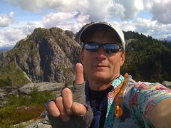
curious bunny trail
When we were on Crown we also met some people who had accidentally taken a left very near the top, taking them along a little trail that apparently got a little nasty. Seems like a common error, though I'd have never noticed it if we didn't run into these guys coming off it and trying to find the proper trail.
wow
impressive!
STUD!
epic day.
A Spectacle and a Jewel
While on my CFA run up Hanes Valley, and after bumping into Mr. Jackson at midpoint between the two of his first peaks today, I squeezed in Crown and West Crown. The first I did with Heather and Liza and the latter was by my lonesome. If you've not been to either, Crown is spectacular if not a bit too crowded on a sunny Saturday in August. West Crown is a jewel among jewels with not another soul to be found and a view of West Van. and Vancouver, and beyond, beyond belief. I sat a while on both peaks but took the longest on West Crown and would gladly go back there at my first chance.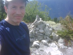
Crown from West Crown
Summit of West Crown
Lovely Sleeping Beauty
Glad you opted to get this one. With you on this being a gem. Sure would be a nice place to pitch a tent for the night, eh? I sat there for about 1/2 hour feeding trail mix to the chipmunks and listening to the logger show at Grouse. Didn't note much green tape, however. Looking north west, makes you wonder what marvels await in the Forbidden Forest, doesn't it?
a unique view...
I've never seen that northwest forest in such grandeur before. So inviting.