 See the 360 degree video here.
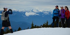
Are you still thinking of doing the Vancouver 100? This photo will give you an idea how fantastic the view is from atop Black Mountain. This was taken May 14, 2011 when Neil, Carolyn, Marla, Liza, Dave and I went out for a little 4 hour tour to the bluffs and back from Cypress Bowl. I would say the snow was deep and soft enough for a little breast stroke swim. Dave and Neil gave it a shot without snowshoes but with their yaks but I think the jury is still out on whether or not it was worth the extra energy of postholing. Hopefully event day in 3 weeks will bring more firm snow.
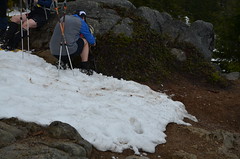
I'm not sure what Dave is doing in the photo below but it looks important. This was the end of the snow at the bluffs. Remember that distances shorter than 100km are welcome. Sign up here.


Comments
Getting ready for Vancouver 100 - part II
Hello all of you Vancouver 100 fans!
Well Craig is right in regards to the amount of snow and the ever changing conditions!
Myself, Doug, Dana and Devah started at Cypress and trekked out towards Hollyburn XC area. We flagged the route with Pink and black stripped tape to try to make finding the BP markers a little easier. The markers are starting to show now as the snow line is receding, so look low!
We made it to the start of the XC trails in about 1:05 and made the return trip in about 48 min. We then decided to head up to Black Mountain to check out that part of the trail. I always have trouble finding the start of the BP from the lodge so we took the 'classic KK route' by making a direct assault up the ski runs. We then found the BP using Doug's GPS passed by Black mtn, headed back and regained Black.
We then found Craig's crew's tracks and headed down the current (and correct) BP winter trail.
As a side note once we hit the trails off the ski runs at the top of the chair I had snow shoes and the others in my group did not. Doug was post holing every 4th step and the ladies were probably a little better off because they are lighter. I had no problems whatsoever. That being said (and Craig mentioned this as well) the snow may consolidate even more so snowshoes may not be an advantage.
One thing is certain there will be tons of snow, so be prepared to run in it, and post holes will be inevitable.
A word of caution the Cypress/Hollyburn traverse, there were snow bridges when we went through but they will no longer be there in 3 weeks, so climbing in and out of those creeks will be treacherous!
We hope to go from Nelson Creek up to Black or Eagle bluffs either during the week or this coming weekend. We'll report on that later!
Cheers,
Mike
thanks for the flagging
Your flagging was helpful to us today Mike. We did Nelson Canyon to Cleveland Dam today. The snow is melting quickly but of course there is still lots and lots and lots. It was the usual culprits, Neil, Carolyn, Liza, Marla and me. Liza and Carolyn stopped at Cypress Bowl after about 4 hours and Neil and Marla and I trudged on through the Hollyburn trees and down to the chute. It was not quick but we kept moving pretty much the whole time. Total time was 6:45. I had predicted 6 hours so that's a bit of a wake up call. Thankfully we didn't get rained on heavily but it was cloudy and misty almost the whole way. This time, no snowshoes, just some yaks and gators and that was fine. Not too hard to find the trail but we did wander a bit through the Hollyburn trees. All in all an epic little training run with lots of fun bits.
Trail report - May 26th
*Before* the backcountry preparation talk on Thursday, I went up BP from Cleveland dam towards Cypress.
I made it as far as Hollyburn Lodge before running out of time. Under the tree cover, there was little snow (never more than 50cm, and it's usually possible to sidestep the deepest areas), very easy to negotiate.
On the ski runs, there is a lot more snow. On Thursday, around 4pm, on a partially sunny day -- 14C at YVR aiport -- the snow was still very hard on the slopes, and even in Fivefingers I never sank deeper than 15cm -- usually a lot less. Running down on the ski slopes is really a lot of fun. Somebody should make that into a competitive sport.
After a week of warmer temperature and possible rain, the trail may look quite different. If it stays hard like that though, it will not be too difficult.
Trail update May 26th - Cypress to eagle Bluffs return.
Hello all!
Well I have to agree with Eric that the conditions are 'ever changing' and that we don't really know what we are going to get on race day. One thing I have to point out however is that the section that Eric did varies only slightly from year to year in that the fact there may be a 'lot' of snow or 'a little less' but the results are typically the same, harder snow early in the day and softer on the return!
Repeating the section we did from Cypress to Eagle bluffs was of great interest to me. One was to definately decide if snowshoes would be a benefit (although not totally necessary) and two was to get the route nailed and finally are using Yak tracks or micro spikes a big enough benefit for th extra weight on the feet.
The snow up the BP 'winter' trail was a little soft and deepish. It had snowed during the week and filled in some of the track. I was using poles but no spikes, Colin and doug both had spikes on. No big advantage here. Time to Black Mtn ~40 min at a moderate/easy pace. Continued on to Eagle bluff. Snow was a little harder in the trees, track was a little harder to find but not too bad. Snow was much deeper in the open areas heading to Eagle Bluffs. Tricky navigation as all of our previous (and Craig's group) tracks had been filled in with new snow. Time to Eagle Bluffs approx. 40 min. Snow pretty much stops at Eagle Bluffs. Return back up to Black along our well trodded route was about 25 min. I tried using the micro spikes to get a comparison and found that they didn't add a lot of benefit for me. i took them from Doug so he had none and made the same comment. I wore shorty gators which was great, probably could have had 2 pairs of socks as my feet were getting a bit cold. Return to Cypress from Black approx 20 min at a moderate/fast down hill pace. Footing is tricky because you don't want to 'posthole' which we all did at least once on this section.
So my gear recommendation: shorty gators, warm long socks, (I wore shorts), poles (you can drop then at Eagle Bluff and pick them up on return and then leave them at Cypress), I don't think you need micro spikes, but that's personal preference, and I don't think snowshoes would add an advantage unless conditions change drastically!
Pace - take it easy! Once you hit the snow you are in it for 1/2 the time you will be on the full 100 course. Save the running for the 'snowless' part.
Now you have all of my secrets! Have fun tapering, see you all next weekend or at Karl Meltzers talk at Kintec Thursday.
Cheers, Mike
I went back yesterday and ran
I went back yesterday and ran the section from Cleveland dam to Horseshoe Bay via Black Mountain.
I started just before 8am. As it turned out, a training run for Kneeknackers started soon after me. They caught up with me after about an hour. I passed them back at Hollyburn Lodge while they were regrouping, they then caught up with me again, and I enjoyed some company on the way to Cypress, where they turned around. This section of the trail has now been run by a pack of 15-20 people which should make it even easier to follow.
The pink and black flagging tape recently added by Mike et al. is helpful in the XC ski area, where there still is a lot of snow. In particular, finding the trail heading into the forest, on the last ski run, would be near impossible without the tape. Thanks.
There may have been some bear footprints on this section, as well as on the top of Black Mountain, but I'm no expert.
The snow on the ski runs is similar to my previous visit, Thursday. It did seem a bit softer, though, making it harder to run, even though it was earlier in the day (around 9am instead of 4pm). In the section to Cypress, back under the tree cover, the snow was mostly packed (melted and frozen over), but not too hard as to be painful on the legs when falling through. There is enough snow there that while wooden bridges are nowhere to be seen, crossing creeks is easy -- just look around for areas with enough snow. However, some of these snow bridges may be pretty fragile a week from now. Beware.
From the Cypress parking lot to the top of Black Moutain, I couldn't seen any markers, so I had a quick look at the various maps on display there that have BP on it.
On the top of Black Mountain, by the ski lift, I couldn't find trail markers either, so I cut across trees towards the first lake, followed along its West side (not sure how thick the ice is -- water is exposed in one place). After passing the lake, I took a sharp right and caught up with trail markers that are then very easy to follow. That's probably not the exact way to do it.
Before getting to Eagle Bluffs, I lost trail markers for a short while and ended up going too West (by 100m) and too low (by 80m, it's very steep) where other unrelated trail markers led me to the creek at the bottom there. I quickly noticed something was up and went back. So keep your eyes open in that area: you shouldn't be going down significantly until you get to Eagle Bluffs. The snow has more of an ice cover in that section and it's certainly less nice. Gators may have avoided me some cuts and bruises from the ice.
As Mike says, the snow stops right at Eagle Bluffs, where the view was really beautiful yesterday, a really great day. It took me 6:20 for the whole thing, including half an hour on Eagle Bluffs enjoying the view and thawing my feet.
P.S. On the way down to Horseshoe Bay, there are a couple of loose large rocks that you may be tempted to use as seemingly strong hand holds, but they will not hold your weight...