1. STAR BAGS: certain extraordinary methods of bagging will earn the bagger a coveted star after the peak, which stars will count as tie-breakers in totals. There are three kinds of star-bags, all of equal weight:
a. WATERBAGS: An ascent up a single peak linking sea level to summit counts as a waterbag. Only one peak per sea level ascent. e.g.: Dip toe in ocean at Ambleside Beach. Run up Capilano Trails and Nancy Greene Way and Grouse Grind. Summit Grouse, Goat, and Crown = 1 waterbag, not three.
b. TRUE BAGS: as the true peaks of Crown and Gotha are semi-exposed, and there is a false summit very close, attaining the false peak will get you the point, and attaining the true peak will be starred.
c. GIFT BAGS: during a bag, doing an hour or so of trail maintenance (through trail flagging, sawing of limbs and suckers, and other trail maintenance) will be starred.
2. SPRING BAGS: in addition to the Howe Sound Island peaks, we've opened up the "front row" of more easily-accessible peaks to the April starting date, for anyone who wants to try a snowshoe bag. ONLY TRY IN CLEAR WEATHER and ALWAYS CHECK THE AVALANCHE REPORTS and BRING THE PROPER EQUIPMENT and BE CAUTIOUS!: BLA, HOL, STR, GRO, DAM, FRO, SLY, LYN, SEY, SUI, DEP.
3. GROUP BAGS: we hope to run a few "guided tour" Flash Events throughout the summer. The remote and rewarding playground of Mt Capilano will be a likely destination.
4. NEW BAGS: Added Suicide Bluff, which has a prominence of 57m. Easily accessible from Seymour Parking lot. We believe that we have now included all peaks that meet the criteria, but welcome nominations for additional peaks. We're eyeing some within-criteria peaks between CRO and PER, as well as the distant back-door bags of Bivouac and Eldee, but these are likely horrible and dangerous. The administrators reserve the right to add further peaks at their sole discretion at any time.
LOCATION: North Shore Mountains
WHAT: See how many North Shore peaks you can run up and bag in a summer. All but the island mountains qualify as munros (in excess of 3000 feet) under the Scottish peak-bagging system.
DATES:
Mainland peaks: June 23, 2012 to October 25, 2012 at 6:30pm
Howe Sound island peaks and front-row peaks (ONLY): April 1, 2012 to October 25, 2012 at 6:30pm
WHERE: non-technical or less-technical (Class 3 or easier) North Shore mountains (listed below). The peak must have its own name AND it must have a prominence of at least 50 metres (i.e. to climb to the next peak one must first descend at least 50 metres).
RESULTS: Post a comment setting out your mountainous conquests (or email "David Crerar" via the CFA Message email service on this site (see left column)), with the dates, and I will post ongoing standings. Please also feel free to post your trip reports in your CFA blog (log in and go to www.clubfatass.com/node/add/bog).
YOUR STORIES: CFA and your fellow Baggers love to hear about your Bagger Adventures. To share your stories, we recommend you blog about them in your CFA member blog. Log in, then go here to get started. You can read about the 2012 adventures posted so far here.
PHOTOS: Please post your photos, too. Add to the CFA Flickr Pool (instructions here. It's easy!), tag your photos: ClubFatAss ClubFatAssEvents ClubFatAssEvents2012 BaggerChallenge2012 BaggerChallenge (with a space separating each tag on the flickr template)
2012 Photos
Photo Archives
ARCHIVES
2011 Munro Quaich: Bill Maurer: 50 peaks
2011 Pippa Quaich: Carolyn King: 33 peaks
2011 Harry Quaich: Harry Crerar: 10 peaks
2011 Tundra Quaich: Tundra the Ultra Dog: 22 peaks
WINNING TIE-BREAKER MECHANISM: In the case of a tie for first place:
1. non-core peaks (i.e. those not on the North Shore and not listed) will not be counted;
2. if still a tie, the bagger with the most starbags (i.e. 1. water bags (i.e. peaks ascended from sea level to peak: see below) 2. true bags (i.e. true summits of GOT and CRO), 3. gift bags (i.e. trail work)) will win;
3. if still a tie, the bagger with the most unique bags (i.e. peaks that no one else visited) will win;
4. if still a tie, the bagger with the most write-ups and comments posted on the CFA Flickr website will win;
5. if still a tie, the bagger with the most photos posted on the CFA Flickr website will win;
6. if still a tie, the bagger with the most obscure/difficult bags (at the completely arbitrary discretion of the host) will win.
PRIZE: The winner will be the proud bearer of the CFA Bagger Munro Quaich cup for the year: the appropriate cup from which to drink a winter whisky and contemplate how awesome you are. There will be an auxiliary prize for the person who draws the most other people into the cult of peak-bagging.
BAGGERS' BANQUET: To cap off the bagging season, we will either have a get-together at a pub, or else a barbeque for all bagger participants and their significant others. The Bagger Quaich will be awarded.
Date: Friday, October 26, 2012. 6pm - 10pm.
Place: t.b.a.
NO SANDBAGGING: all claims to bagging a peak must be submitted as promptly as possible (in most cases, within 3 days) of the actual climb. Climbs of more than two weeks old will be stale-dated for baggers already in the contest. Old bags by new baggers will be considered on a case-by-case fairness basis at the sole discretion of the administrator: late bags by new baggers late in the season will likely not be counted.
ENTRY: There is no fee and you don't need to be a member of Club Fat Ass to participate in a Flash event, however whining is not allowed. That being said, many of the peaks listed should only be attempted by those with the experience and fitness level of a typical Club Fat Ass member (i.e. ample mountain running experience over long distances).
IMPORTANT SAFETY CONSIDERATIONS: All of these adventures are potentially dangerous.
You are responsible for your own well being and safety and should be self sufficient.
Here are two useful lists of "MUST HAVE" survival items that all participants should carry:
Mountains marked with a !!! are scramble ascents or otherwise exposed or otherwise remote and undeveloped and should only be attempted by experienced climbers wearing helmets, etc. Don't try these routes in anything but perfect weather.
Use great caution when rocks are wet -- slipping is the cause of most accidents on North Shore mountains.
Always run/hike with a buddy.
CFA reserves the right to remove anyone from the Challenge for doing reckless, dangerous, destructive, or foolish actions.
PARTICIPATE AT YOUR OWN RISK: YOU ARE WAIVING LEGAL ACTION: By participating in this event you agree to be wholly responsible for your own well-being and agree not to sue anyone associated with this event or Club Fat Ass or any person in relation to this activity. By participating in this event you agree to the terms of the Release of All Claims.
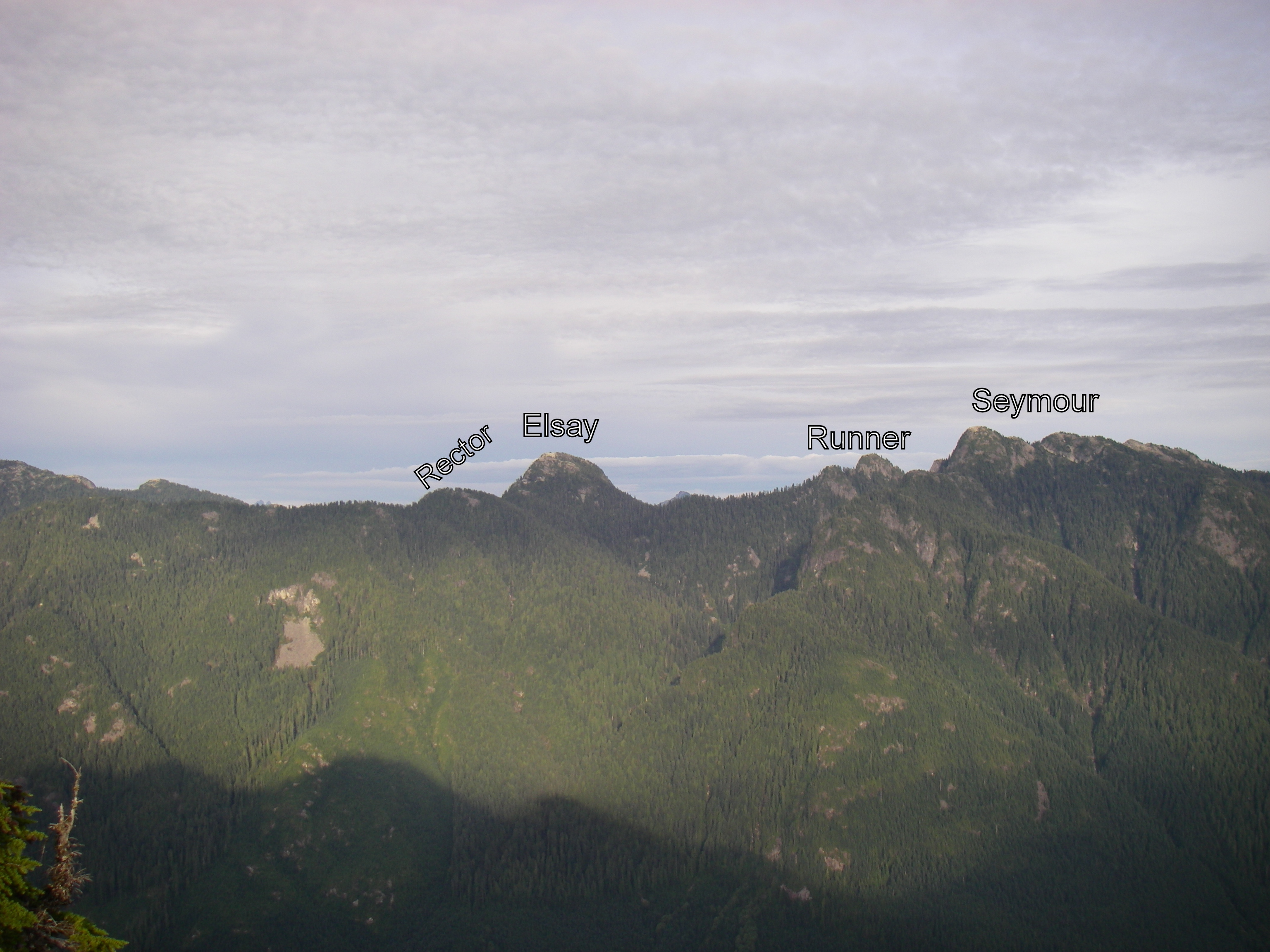
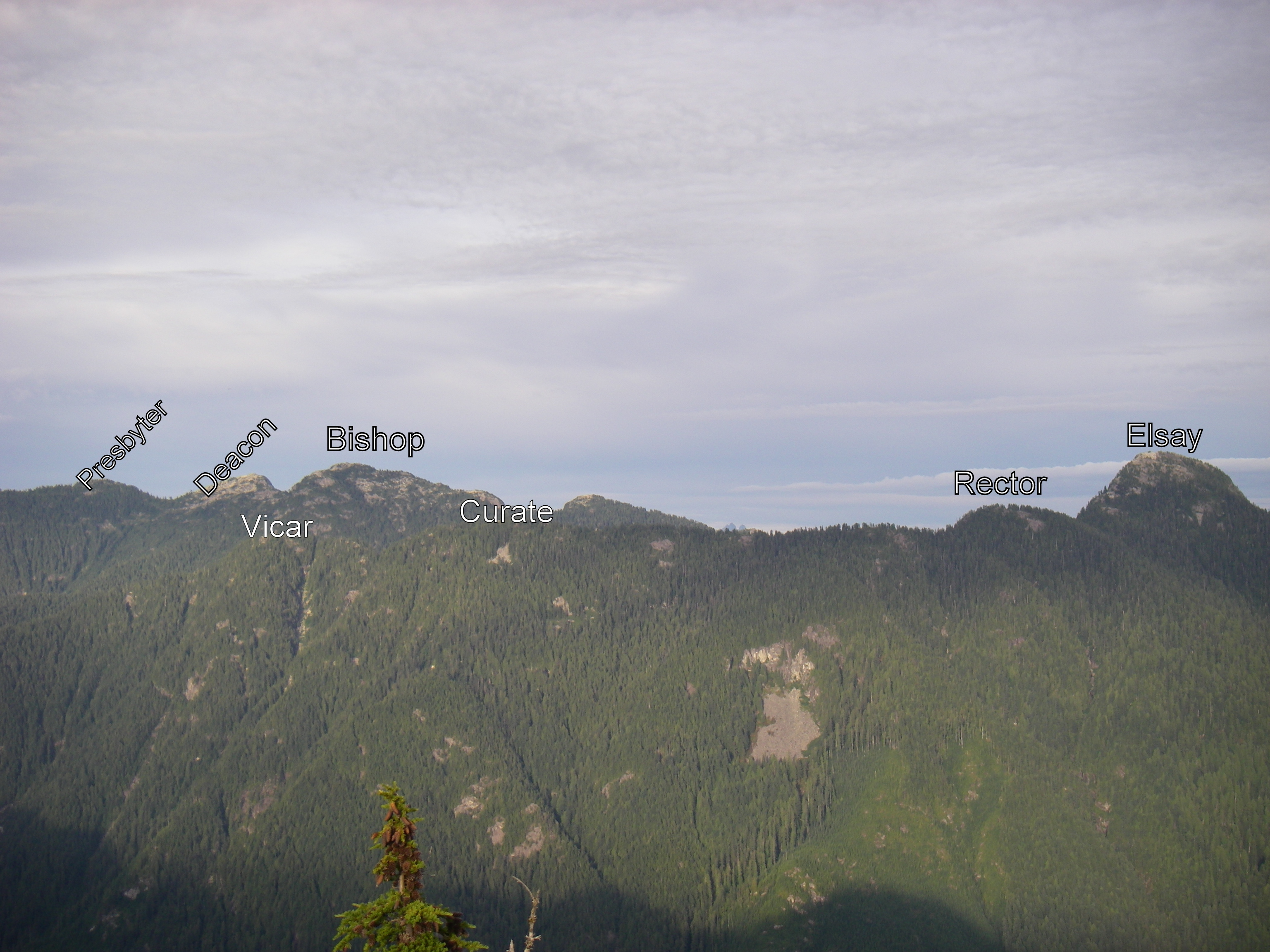
THE 57 NORTH SHORE PEAKS (ranges from west to east)
Altitude listed first, in brackets (metres)
# = Top-12 highest peak
P= Prominence (distance one must first descend before climbing next peak)
[[[ = NOT AN OFFICIAL PEAK in the Bagger Challenge, due to real exposure. Should only be attempted by experienced and competent alpinists. Attaining one of these peaks will nonetheless count as a bagger point.]]]
Peak notes (in round brackets at end)
peaks in italics indicate those baggable from April 1st.
for greater certainty peak ("pk") location among several possible summits (North,South, East, West)
*** as the true peaks are semi-exposed, and there is a false summit very close, attaining the false peak will get you the point, and attaining the true peak will be starred and count as a starbag (i.e. a tie-breaker).
e.g. the proper peak of Crown is a hair-raising wedge of rock with an impressive drop on 3/4 sides; attaining the (unscary) platform just below this true summit will get you a point).
e.g.2 the proper peak of Gotha is the south peak, which is a semi-hair-raising traverse above a semi-sheer drop into Deaks Lakes way below; attaining the northern peak, with nearly identical height, will get you a point.
Resources and hyperlinks
103 = Bryceland & Macaree, 103 Hikes in Southwest British Columbia
MG = Matt Gunn, Scrambles in Southwest British Columbia
DH = Dawn Hanna, Best Hikes and Walks of Southwestern British Columbia
12= trip reports and maps
AB= peak photos
Note: the links to trip reports won't work unless your page is set to "50 comments per page" (the default setting)
Difficulty and Quality Rating {purple; in fancy brackets}
Difficulty: Hard; medium; easy
K = best hikes for kids
!!! = Dangerous: exposed or real risk of falling rock
!!!!!!!!! = Very dangerous; experienced mountaineers only
&& = trail at times faint or nonexistent; need route-finding skills
Quality: 1-5, with 1 being the best and 5 the worst
For a guided tour of the Bagger Peaks on Google Earth please click download the file attached below and open with Google Earth (and try the 3D flight simulator option under "tools"!)
For a full size Bagger map click on the image below:
Submitted by mkuiack on 28 September, 2012 - 08:55.
From what I've read about Hanover, Ean, not sure I trust myself to not a) break my neck on the Hanover scramble; or b) kick a big rock into someone's else neck. Maybe if I just stood at the base of the gully with a net or giant catcher's mitt to catch any flying debris and/or flying fatasses...
Submitted by mkuiack on 25 September, 2012 - 07:30.
One of my favorite outings of 2011 was to the top of Mt. Harvey, so I looked forward to going back to the same neck of the woods on Saturday to bag neighbouring Brunswick Mountain, elevation 5,866 ft. If all went smoothly I’d pick up Fat Ass and Hat at the same time. Arrived at the tiny Lion’s Bay parking lot on Sunset Drive at 7:15am and fortunately was only the 2nd car there.
Headed up the same wide gravel road as to the Lions Trail, turned left at the colorful sign marker around 20 minutes in. The remainder of the first hour or so was on a beautiful runnable trail that wasn’t technical and that varied in width from that of a narrow road to double track. A joy to run on. Wet leaves and bush that hugged the trail at times and slapped you as went by was only a minor irritant. You first run past Magnesia Creek, which was easy to walk over with only the slightest foot splash. Moments later turned upwards at the blowdown spot where the Hat/Tunnel Bluffs Trail keeps going. The elevation gain was slight for stretches so you knew you were only delaying the inevitable, with a few thousand feet of gain still to come, but was easy to ignore that and enjoy the good trail while it lasted. The trail did of course get steeper eventually and any running slowed to a hike for me, but the cool weather was ideal for the climb upwards.
The Brunswick Trail after awhile intersects with the Howe Sound Crest Trail when you’re almost at 5,000 ft of elevation. This is a fantastic 4-way junction. Good choices all around – up to Brunswick Mountain, down to Lion’s Bay, left to Brunswick Lake, right to Magnesia Meadows. Decisions, decisions. At this point I still hadn’t seen a soul all day, and so high above civilization you feel the area is practically your own private playground.
The work picks up somewhat, as you make your way up more steeply now past pointy rocks and with quite loose gravel underfoot slowing you down a bit. Route very easy to make out though. Given the cloud cover which dropped visibility close to nothing, I naively thought I might be taking my final steps to the Brunswick summit but in fact soon learned it was only to be the saddle/ridge. It’s then probably only another 500m or less to the summit but there were steep slopes (especially to the left into a snowfield bowl) off of the narrowing ridge and I found it rather nervy going for awhile so made my way gingerly. The more confident and sure-footed among you would have no issue with it, but I’m neither. So this was a good time to suppress my clumsy side. Having said that, it wasn’t really too difficult of a scramble, there was no rush, I managed.
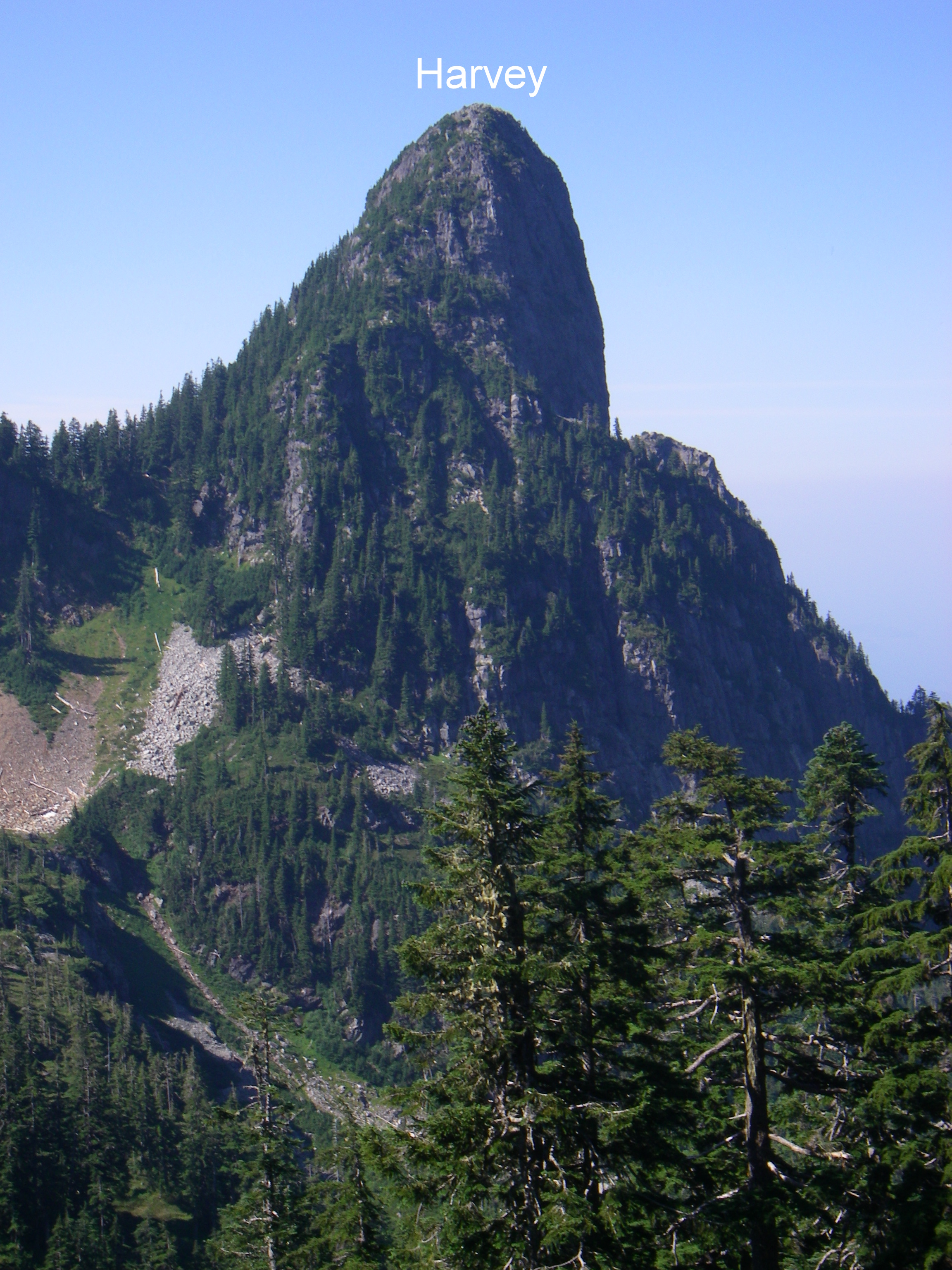
The views from the peak are reportedly breathtaking. Howe Sound, the Lions, Deeks Lake, Garibaldi, etc. I couldn’t see a thing. One mountain poked out, I’m guessing it was Hanover. A part of another mountain, likely Harvey, appeared for a moment in the other direction but in the 30 seconds it took me to unzip my pack, take out my iPod Touch for a photo, and aim in that direction to capture the eerie scene it had vanished.
Back at the intersection, I headed towards Brunswick Lake but missed the trailhead at Hat Pass for Fat Ass Peak and Hat Peak. I wasn’t looking closely enough – I now understand that it was near the tarn that you pass around 1/3 of the way to Brunswick Lake from the 4-way junction. Soon I was losing elevation so I knew I had gone too far but ending up at Brunswick Lake is never a bad consolation prize. Encountered my first four humans of the day, filled up with water at a creek approaching Brunswick Lake, flipped through the logbook at the Brunswick Lake emergency shelter, and dropped my gear to stroll down the lake shore to relax for a bit. Then back up to the junction and then the long downhill, most of which you could really blast if you so choose, back to the now full parking lot. Time out, including the breaks at the peak and the lake, was a shade under 6 hours.
An hour after my return to the parking lot I was home, showered and back out to T&T experiencing the culture shock of going from the solitude of the upper trails to jostling for coveted moon cakes with dozens of shoppers.
An 0-fer on the views and a 1 for 3 on intended baggage, but a memorable excursion that I’ll most likely repeat next year.
Submitted by jessdagg on 24 September, 2012 - 18:08.
Bill posted way below our adventure bagging de Pencier. Not sure if it was caught or not, but we did it on Saturday. DEP for Bill and Jess (and Sierra). Cheers
Today was one of those days dreaded by peace and quiet loving parents, yet loved by eleven year olds everywhere, the Professional Development Day. Since the boy wasn't in school, I decided to play hookey from the job and take him up to the fresh air for some peak bagging adventures.
It was a grey, cloudy day but we made the best of it. Up the BCMC, then onward to Little Goat, Goat, Dam and Grouse. It was a shame that there were no views, but we got to see Crown looming above the mist, so that was nice.
We met a guy on Little Goat who had seen a cougar there, right in that little meadow, last week. We had no such luck, although there would be lots of "would you rather" talk the rest of the day involving various beasts and predators and what we should do if we encountered them. Any opportunity for a learning experience... the boy's teacher would have been proud.
Submitted by mkuiack on 24 September, 2012 - 07:53.
This past Friday was the first dreary day in Vancouver after a glorious stretch of sunny mild weather, but I decided to bag Fromme regardless. Last year I had done Fromme by following Bill's Trail up from the quarry off of Old Mountain Highway, so I decided to mix it up with a different route this year. I made killer time at the beginning, storming up a 3,000 ft ascent in only 8 minutes.
My surprise reward after getting off the Skyride was sunshine and relative warmth, as we had popped through the clouds. Jogged downhill on the logging road for around 15 minutes before taking the Pipeline Pass trailhead on the left, then turned right to Fromme at the well-marked junction a few hundred feet in (made a note of it for my return). Neat perspective from both the north (Senate) and south (true summit) peaks of Fromme, as the cloud level was about 200 ft below the Grouse Chalet so all you could really see in any direction were peaks poking out like islands. Back down, at the Pipeline Pass junction turned right onto the Erik The Red Trail, flattish for a short while, descended down to a creek and then back up towards the Thunderbird Ridge trail. You end up on the Alpine Trail for its 2.2km path back to the chalet.
I couldn't help but gloat a little after having enjoyed the sun while Vancouver was grey the entire time, but I should have known not to do so as the next day the tables were turned on me ...
Submitted by mkuiack on 23 September, 2012 - 19:32.
I had thought of bagging Suicide Bluffs when I bagged Seymour and DePencier a couple of weeks ago but deferred. It’s just as well, because it became a nice little bagging trip on its own on a pleasant late summer day last week. In fact, along with Hollyburn via the Cypress downhill parking lot, I think this may become a preferred route of mine when a friend or client with some trail running or hiking experience comes to Vancouver and wants an introduction to a North Shore peak that could be done in well under 2 hours after work.
Unless you have time constraints or are tacking this onto other Seymour area peaks as part of a longer day, I’d recommend the Seymour downhill parking lot-Dog Mountain trail-Suicide Bluffs-Seymour Trail-parking lot loop as David suggested. The loop I’d estimate adds a half-hour or so compared to if you just did an out and back from the trailhead off of the main Seymour trail, but it is more interesting and still one of the quicker bags.
The views from Dog Mountain including back to the city make for a worthwhile 5-minute detour (the trail to Suicide Bluffs heads off north from the Dog Mountain trail just a few minutes before the top of Dog Mountain), then the trail becomes a bit rougher and less-travelled but still very pleasant to the Bluffs. Coming down from the Bluffs and running east, I encountered a friendly group of 10 picnickers from overseas and after declining a politely-offered pickle sandwich I was soon at the main Seymour Trail. Like a couple others have written, while the Dog Mountain trail cannot be missed, if you choose to take the more direct route then the trailhead off of the main Seymour Trail is clearly visible but unmarked – if after starting from the parking lot you reach Brockton Point you’ve gone too far.
This is a welcome new addition for 2012 to the Bagger Challenge peak list.
Had a nice time up on Seymour yesterday. It was sunny and warm and I got there before the school bus full of teenagers, so that was good. Did some wandering around and scrambling on various nooks and crannies on the way down. Everyone I met heading back told me to beware the bear, but I missed him altogether. I thought to go back today and have a crack at Runner Peak but I've got a sick kid, so Runner will have to wait for some other sunny day.
Submitted by reaganwhite on 17 September, 2012 - 16:53.
I bagged BLA with Isaac White yesterday. Isaac is a much stronger hiker this year, what a difference a year makes. Last year it took him over an hour to reach the top, this year only 39 minutes as a 6-year old.
Submitted by Woolly Mammoth Clone on 14 September, 2012 - 14:45.
Just an FYI the main trailhead from Lionsbay is still closed 'until further notice' after the fire last week. Not sure about the one that heads up unnecessary mtn but likely the same..
Deeks, Windsor, Corburg & Hanover will have to wait.. :(
For those of you wondering what's happened
to my bagging activities these past few weeks,
I'm on vacation. Just completing a cycle trip from
Frankfurt to Budapest mostly along the trans
european EV6 route. Fear not, I shall return in
1 week to continue the defense of the mighty
bagger award.
Sent from a campground in Nagymaros, Hungary
Little foggy up there too, but Bill's trail from the gravel pit to the top is pretty much double marked all the way.
I heard the North Shore Rescue folks just put on some new markers there while guiding someone back down. Did they ever do a good job on that one.
My adventures this year are hardly of epic proportions, but for the time being I am on track for my sweep by the time I'm 45 (10 years). Pretty generous timeframe, I know.
By then the kids will be old enough so I can resweep a little faster.
Now that school's in session, peak bagging takes a backseat to parenting. With all these piano lessons, swimming lessons, soccer games and whatnot my bagging adventures must be held between the hours of 9am-3pm on days when I'm not slaving away at my gruelling three day work week. I'm pretty much only good for Thursdays and Fridays now.
The race was on. Could I get the boy breakfasted and off to school, battle rush-hour bridge traffic, get up the BCMC, then Crown, back down BCMC and back over the brigde by 3:00?
Yes, it turns out, I could. Almost. My tired legs and ticking watch forced me to break my golden rule of "Thou Shalt Not Pay To Get Off Thy Mountain" and I took the gondola down. All else went nice and smooth, other than a couple serious don't-look-down moments on the final push to the summit. I saw no human beings from the Grizzly Bears until I was on the return trek up from Crown Pass. It was a very nice day.
Submitted by clarkee76 on 4 September, 2012 - 20:28.
Anyone interested in a bagging adventure this Sunday, probably heading out towards Elsay and maybe beyond, exact destinations will depend on the enthusiasm group. Stetson has seen that Tundra is pulling ahead......
Submitted by reaganwhite on 4 September, 2012 - 14:04.
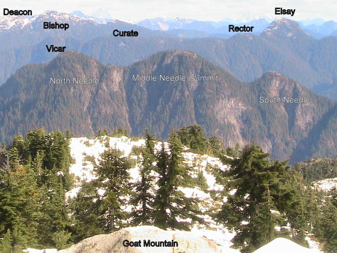
Eric Rannaud and I successfully bagged SNE, MNE, NNE and lastly LYN via Hydraulic Connector yesterday from 7am to 5pm. We needed both of our brains to solve some tricky route-finding beyond SNE to the north, and especially to pick the safest scrambling routes. There's little flagging beyond SNE. Several first impressions of "ok, guess we'll turn around here" were reversed when we found the safe route down (or up). One such passage was a tunnel under some blueberry bushes. The dry and dusty conditions provided great traction the entire day. The brilliant daylight was also helpful. We encounterd no mud or snow and would not recommend SNE to MNE to NNE if any snow or ice is present. The saddle between MNE and NNE is something to behold - treed and filled with bushes but only about 10 meters wide with a sheer drop to the East and rapid descent to the West. Aside from the usual scratched legs and arms, and a shredded pair of thick leather workgloves (they did their job, protected my hands perfectly), it was an adventure we'll not soon forget. Photos to follow.
Submitted by adventuremike on 28 August, 2012 - 08:25.
Nice work so far this year!! Keep it up! I may be back in town by August 31. Do you want company for a bag or two Saturday? Drop me an email AdventuremikeW at gmail.com cheers!
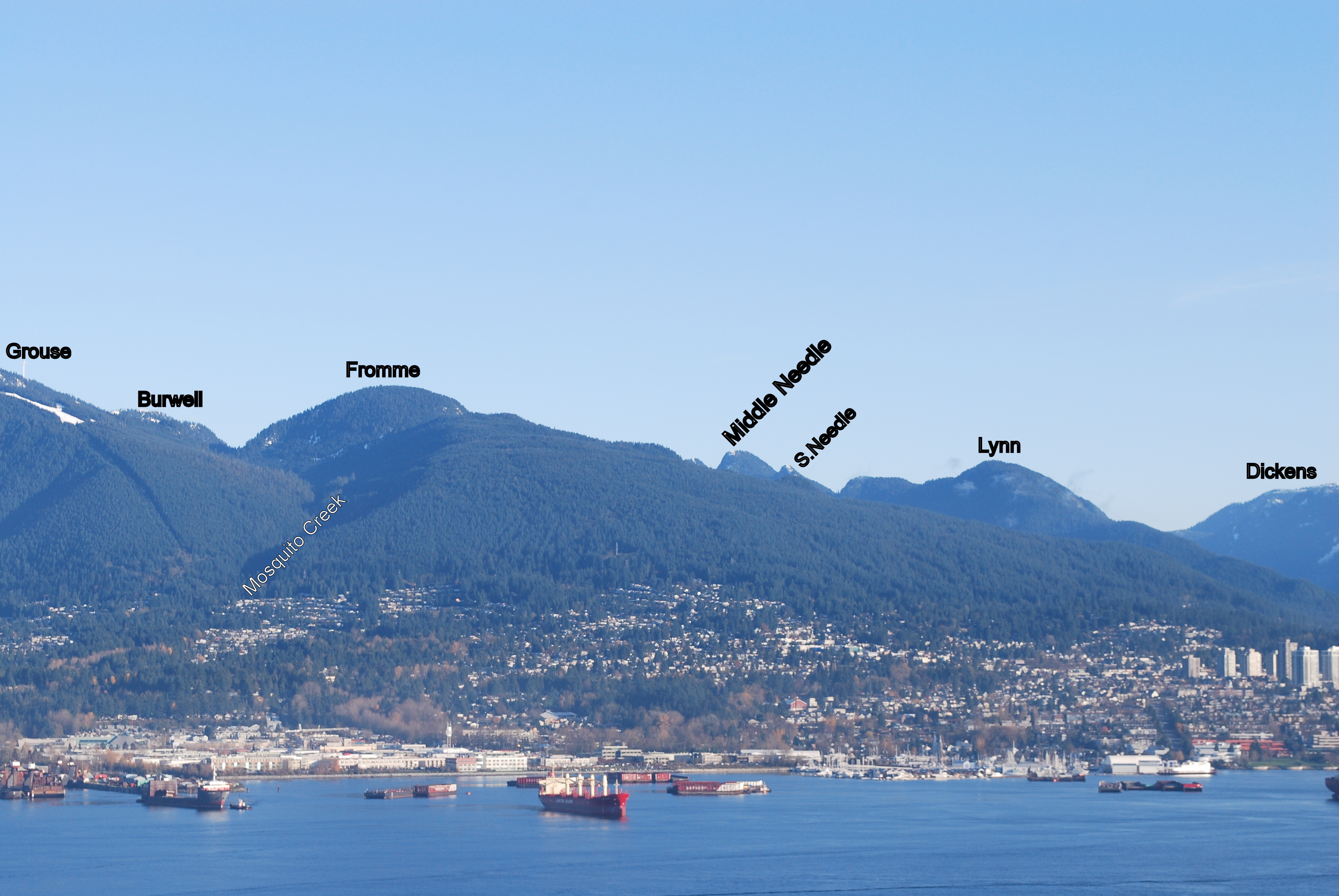
First, some housekeeping. Earlier this year, I had claimed Lynn Peak only to find out that I hadn't actually been on the true peak, just the lowly South Peak. I set out this morning to rectify my error.
Up Lynn I went and once again found myself at the familiar South Peak (SLY). The pink tape that had been around the tree was on the ground and a little chewed up, so I did my best to get it back in it's rightful spot before heading down towards the Needles and the real Lynn Peak. The trail is immediately steep and it set the tone for the rest of my day. After some ups, downs and a pile of blowdown, I see a tree with some tape marked "Middle Peak 1015m". This must be it. I remembered hearing that the actual summit was off the trail, so I looked up and then I went up. Some minor bushwhacking and crawling over rocks and I found it. Put a rock on the cairn and set sail for Hydraulic Creek.
Down the Hydraulic Creek trail to the paved Seymour Valley Trailway was nice. It's steep and runnable in spots, I did what I could. If memory serves me, the trail for Paton would be at 9km. Or was it 9.5km? And what was I looking for again? I ran to the 10km marker and turned around. This time I went slower and peeled my eyes for some sort of flagging. I found some pink flagging and headed into the woods. There was steep hills and lots of bush to be whacked, but no trail. After far too long poking around to no avail, I gave up. On my way back to the start of the paved road, I saw a paved turnoff heading uphill. I followed it and it soon became a dirt road, which soon became a wide trail. At the top there was what appeared to be a real trail with some NSR flagging, so I went in and up. This must be the way to Paton Peak, I surmised. It was steep and it went on and on. Eventually I found myself on the top, put a rock on one of the many cairns and sat down to eat the peanut butter and the jam. I was beat and thought about calling it a day, but the thought of going down that steepness and then running a 10k on the road spurred me on to bigger and better things.
After heading down off Paton, it wasn't long until I was climbing again. Up, up, up... Eventually there was a boulder field and beyond that I was in familiar territory. The trail from the boulders spits you out on the trail just about at the final push to the top of Coliseum. Pretty exhausted and almost out of water, I did the sensible thing and kept going up. I got to the top of Coliseum, had a look around, slapped myself in the face when I started thinking about Burwell and set sail for home. It's been a couple years since I've been on Coliseum and I'd forgotten how long the return trip is. Down, down, down...
In what felt like half a lifetime I was on the Headwaters Trail and it was smooth sailing all the way back to the start.
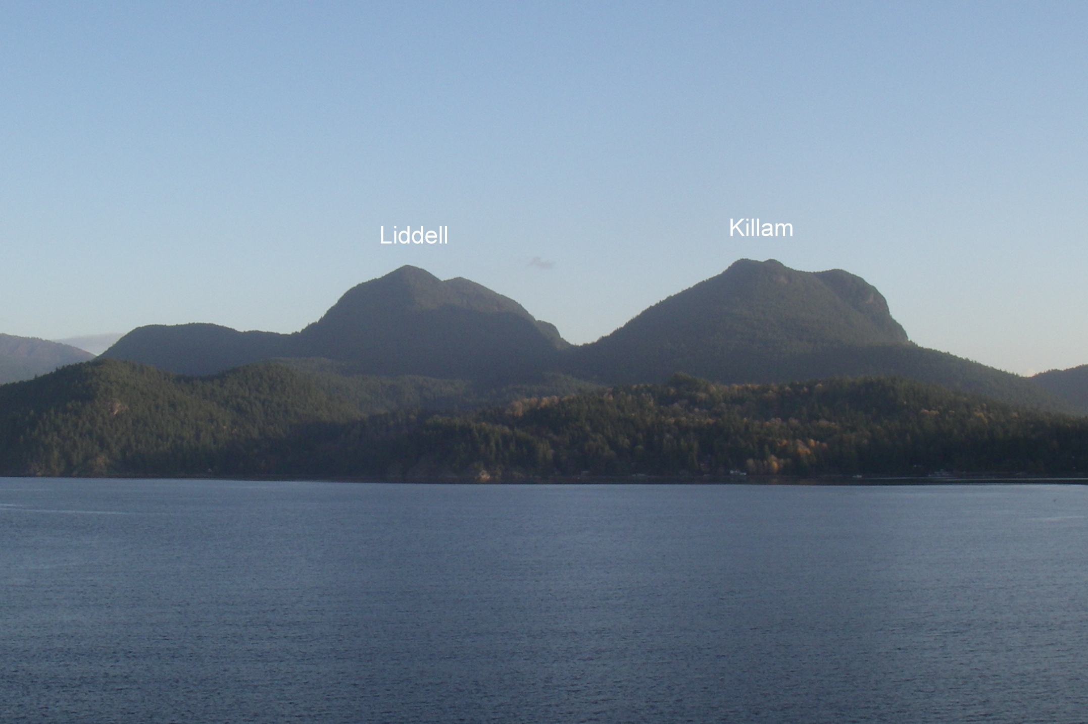
With more good weather in the forecast Linda Malek and I headed for Gambier and Mt Killam on Fri Aug 10. It had alluded me on the Gambier sweep and just needed to be done. We caught the 7:25 ferry to Langdale and the Stormaway to New Brighton with a perfect connection. The trail was well marked although that didn't help us miss it a few times with all the chatting that was going on. Round trip was 5.5 hours at walking pace and distance was 16km.
The return ferry connection was not nearly as good. The schedule has the Stormaway returning from New Brighton to Langdale at 3:25, exactly the same time that the Langdale ferry returns to Horseshoe Bay. We enjoyed the good gelato ice cream at the Langdale kiosk while waiting an hour for the next sailing.
KIL Mt. Killam (844m) (P:324m)
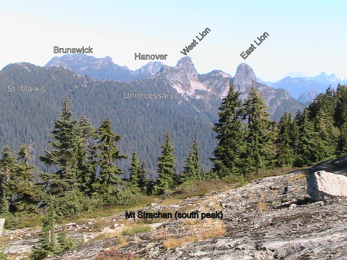
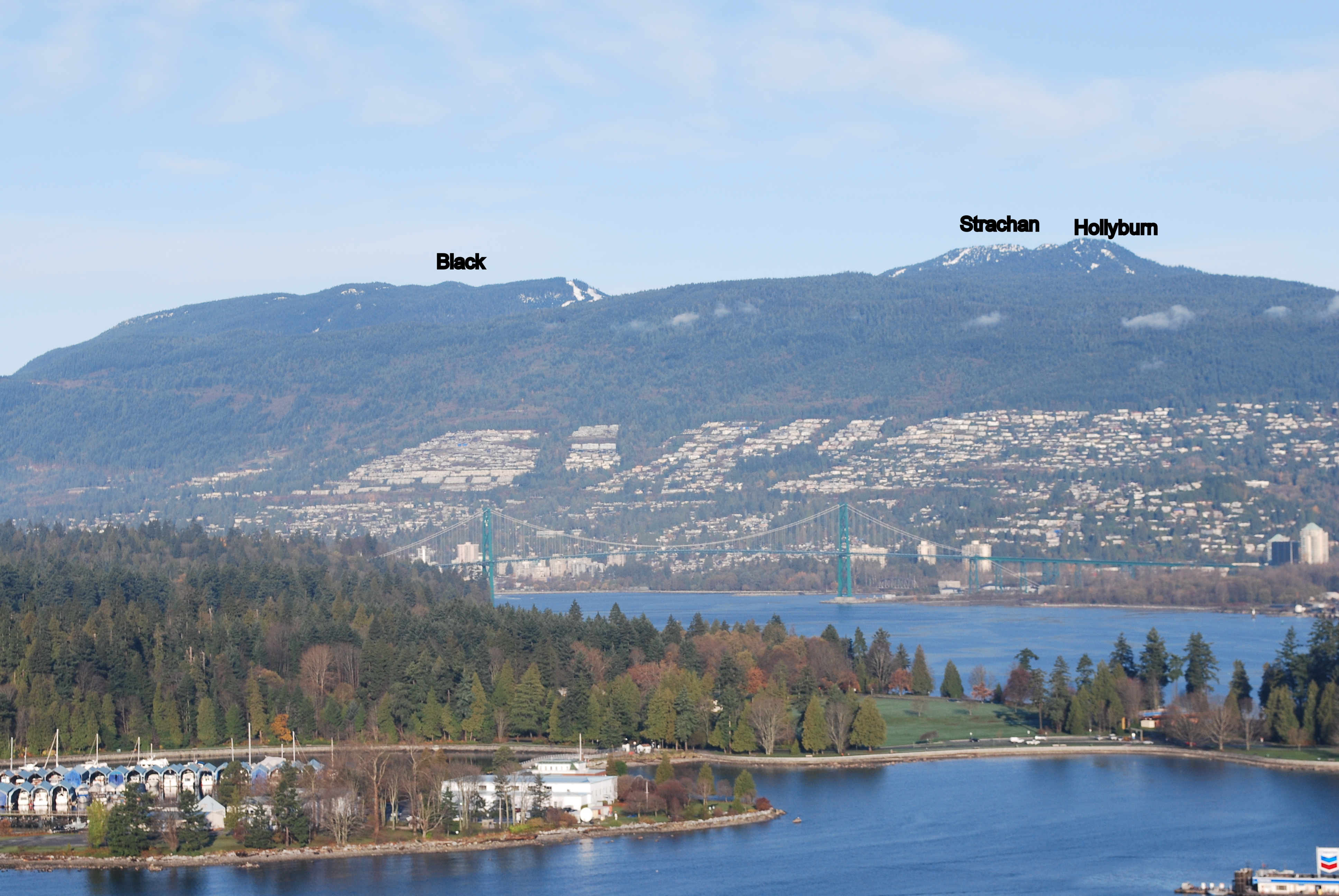
On Saturday, it was time for the Cypress sweep which I was accompanied on with my daughter Annie. We started at 7AM heading east on the BP to the cross country area where we turn north at the Hollyburn trail junction. Then over the top in a northerly direction to the downhill area and the Strachan trail which goes up through the woods just east of the downhill run. We crossed the location of the 1963 T-33 crash site with lots of wreckage still visible. We'd missed this on last year's sweep when the area was still covered in snow. It's located at an elevation of 1310m. From Strachan we headed down the west gully between it and the top of Sky chair to the HSCT. Then up to Saint Marks summit. There is a sign posted "Saint Marks Summit" which is not actually the summit but the viewpoint. The summit is another 40m higher up and can be accessed via a faint trail on its north side. It is a bushy summit with no view. Next we headed for Unnecessary ridge to resolve the mystery of the real peak. There are in fact three peaks on the ridge with the southern one being the lowest, the middle one being the highest, and the north one being 10m lower than the middle one. That means you don't have to go to the north one when doing this sweep although it is the best place to take an unobstructed picture of the Lions. On the return, I ran back, bagged Black, and met Annie in the parking lot. The real Black Mountain is to the north of Cabin Lake although for the purposes of the Challenge and the KK folks, the south summit is also considered a "Black bag".
BLA Black Mountain(1217m) (P: 296m)
HOL Hollyburn Mountain (1325m) (P: 161m)
STRMt.Strachan (1454m)(P: 382m)
UNN Unnecessary Mountain (1548 m) (P: 123m)
MAR St. Mark’s Mountain(1355m) (P:181m)
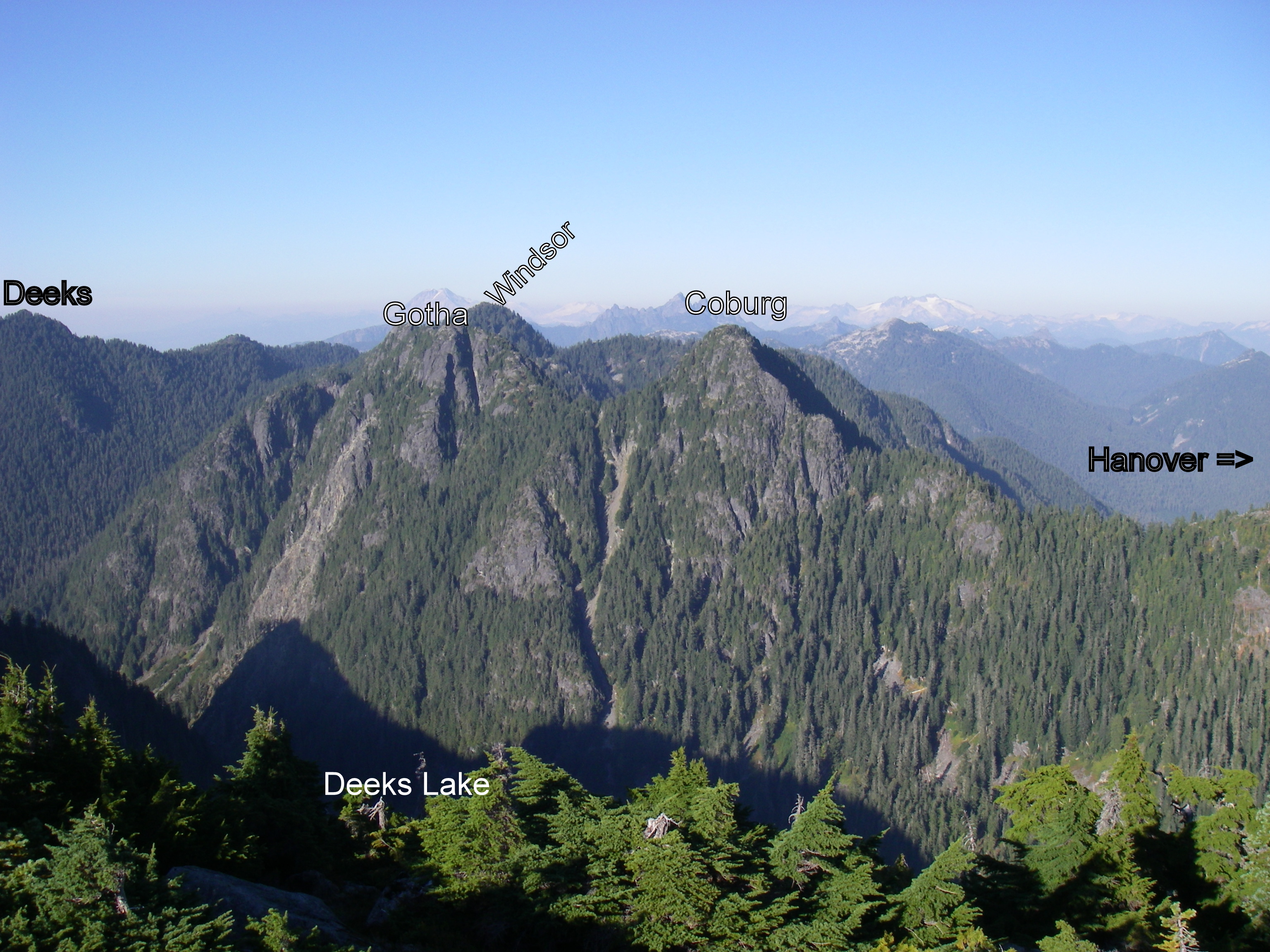
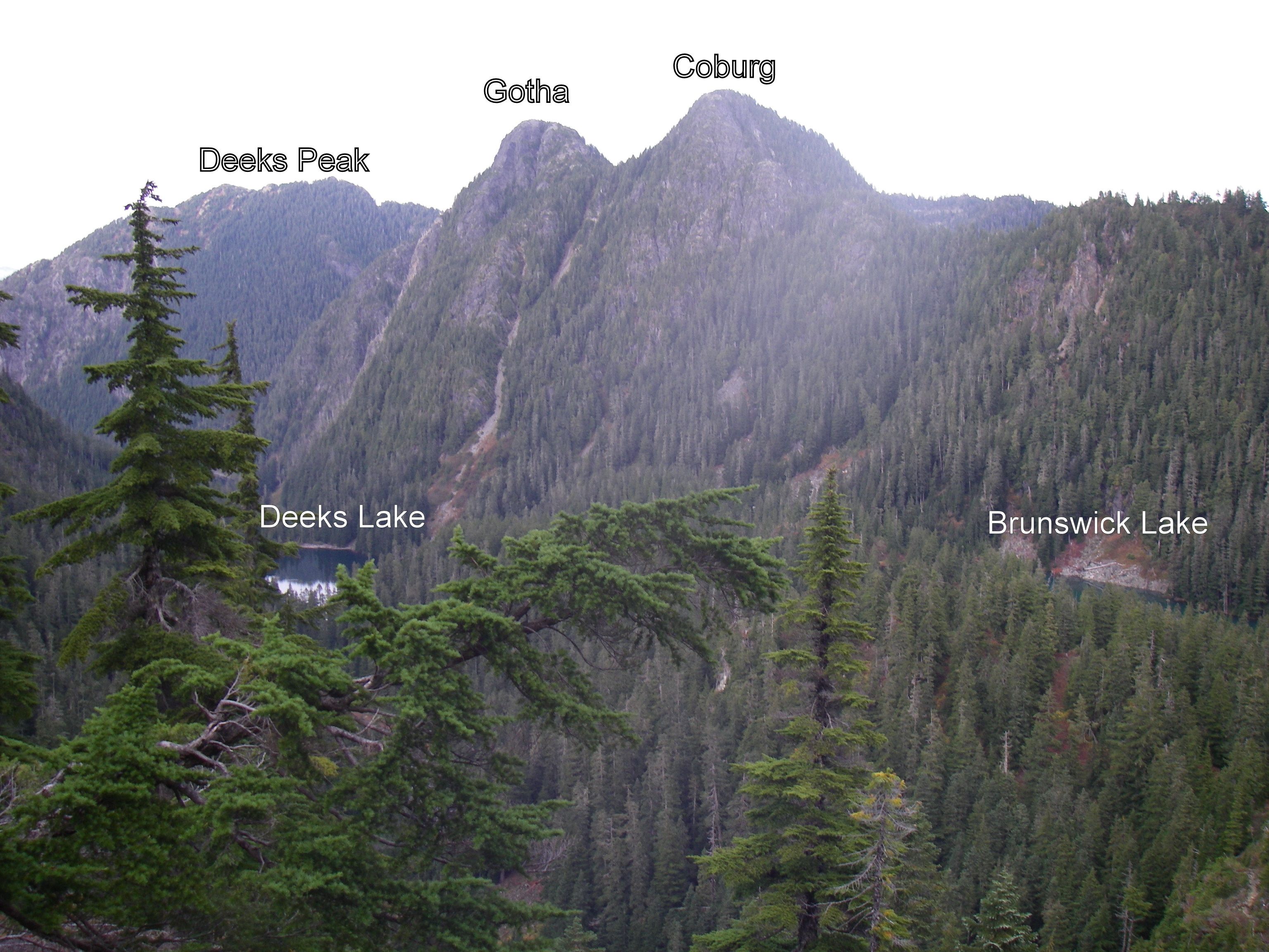
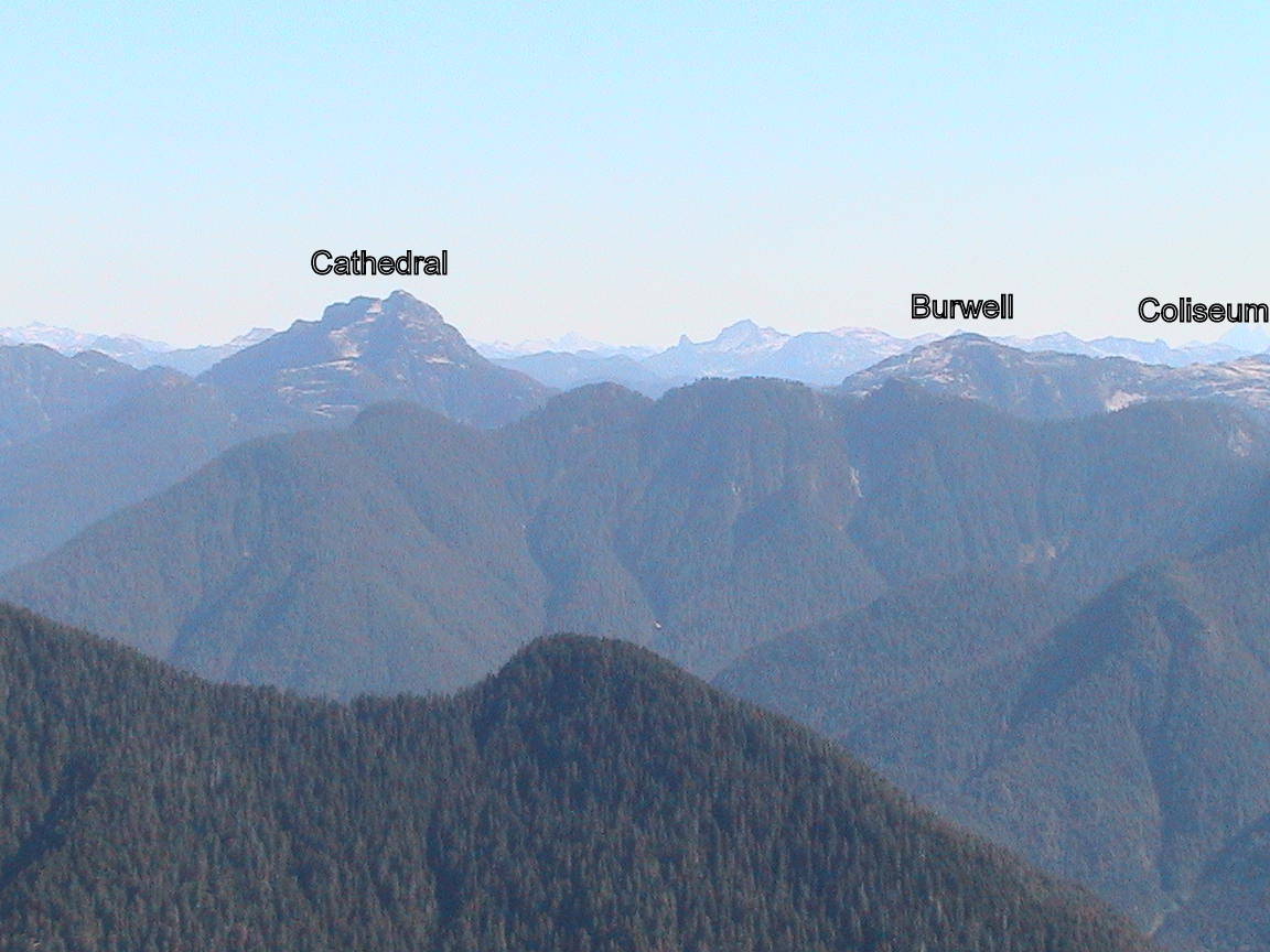
On Sunday, it was once again time to do the dreaded Cathedral sweep. Not having found any willing partners (guinea pigs) this would be another solo sweep. Left the house at 6AM on my mountain bike and managed to get to km 9 of the LSCR recreational pathway by 7AM which is the trailhead. Headed up the steep but well flagged trail to Paton Viewpoint and arrived just dripping with sweat from the hot humid conditions. Then headed up to Colliseum and over to Burwell. I passed a few people that had camped in the summit area but after that I was on my own. There were only scattered snowfields remaining on the north slope of Burwell as I made my way down to the pass between Pallisade and Burwell Lake. I made sure to fill up my water bottle at one of the many streams that were supplied by the melting snow. At first the going is easy but as you cross the pass the bush becomes thicker and thicker and the route only sporadically marked. I was following the track on my GPS which I thought was the route we had followed last year but in fact was hand generated. When I reviewed the notes from that trip, I wrote "Not sure what happened, but my Garmin lost the GPS track for this trip". Too bad I didn't realize that sooner. At an elevation of around 1300m the hand drawn route took me right over a cliff band. I managed but it got interesting with some fancy moves on trees that were just pasted to the side of the cliff. Higher up I ran into some sporadic flagging which improved progress considerably. I suplemented it with a lot more of my own and both the ascent and descent but only on the upper half of the mountain when I was sure I was on the correct route. Don't get the impression that there is a path here because a lot of the lower half of the mountain is just a route through bush.
I got to the top at 2:50 and just enjoyed the sun and view at the top for over an hour. There are nice decks connected to each of the towers. It was just after 4:00 when I headed down. There were some route finding complications as I negotiated the various bluffs but I flagged them as best I could. There is already a fair amount of flagging in this upper section. I found a better route down in the 1300m zone but once again lost any sign of flagging and ended up crossing steep terrain. In retrospect I should have been further south. It was getting late and looked like I would be running out of light when I discovered that I had left my headlamp in my other pack. Great! Managed to get down to near Paton viewpoint by nightfall at 9:00pm. I had a pile jacket and hat with me and it had been a warm day so I lay down in the woods with the mossies and flies and had a light sleep interrupted by a lot of shivering. Most of the bugs went to sleep as it got dark too so it wasn't too bad. Managed to see enough to start moving by around 5:15 and was home in bed by 7:30.
PATPaton Peak(1057m) (P:90m)
COL Coliseum Mountain(1441m) (P: 51m)
BUR Mt. Burwell (1541m)(P: 369m)
CAT Cathedral Mountain(1737m)(P:832m)
They don't call this the Bagger CHALLENGE for nothing! I just know I can do it better next year.
Biked up to the Seymour parking lot this morning to bag the two bluffs.
It was a great day to be out.
Thank you very much to Bill Maurer for posting links and waypoints and therefore pointing newbies like me in the right direction. It can often times make the difference between an uninspired scramble and a successful bag ... or two.
Did 2 sweeps from Lions Bay on Saturday and Sunday. Got to the Lions Bay trailhead parking spot at 6:15am on both days, an assured time to get one of the six available non-resident spots there.
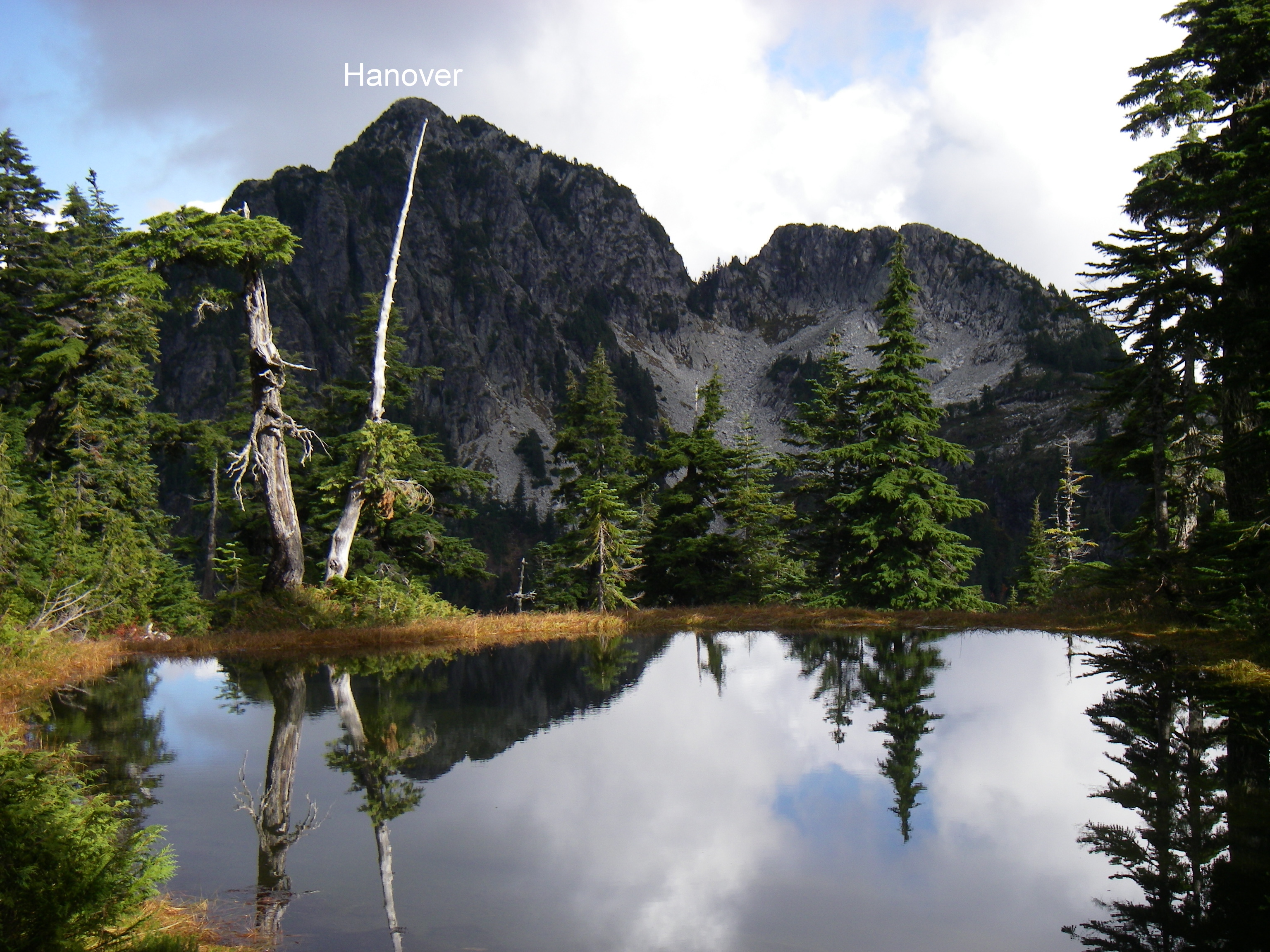
On Saturday headed up the Brunswick trail. Since it's a westerly approach it was nice and cool on the way up. Didn't hit the sun until I got near the summit of Brunswick at 9:10am which was perfect. It seemed like this might be an easier sweep to incorporate Hanover into than the Deeks sweep so I headed down the HSCT to the Brunswick cabin and then Brunswick Lake. From the south end of the lake I followed creek drainages through relatively open territory to the base of the 2 gullies on the SW side which lead to the summit. I took the right one as advised in numerous sources and soon found myself at the base of the first 2 chockstones. I climbed part way up and soon found myself facing a fairly uncomfortable 4th class move. For those not familiar with the grading system, 4th class means "rope up beginners, exposed, a fall will result in serious injury or death". Being solo always seems to add a bit of drama of these moves. I got over this 30' section without a huge sense of relief realizing that I would have to reverse it on the way down. There was a small amount of snow in the gully but nothing that caused problems with the runners. Then up over the second chockstone which was a bit easier and I was soon on top. First time on Hanover. I headed back down and got similarly gripped decending the chockstones. A couple of pieces of webbing or rope would simplify the danger significantly.
On the return I headed straight cross country towards Hat Pass flagging the route along the way. I rejoined the HSCT at the exact spot of the Hat trail junction. If you're coming from Brunswick heading north along the HSCT you turn left (north) to go to Hat or right (south) to go to Hanover. After a short distance of 100m or so you turn down a creek drainage that heads in an easterly direction towards Hanover and then cross open country to a creek drainage coming off the SW side of Hanover.
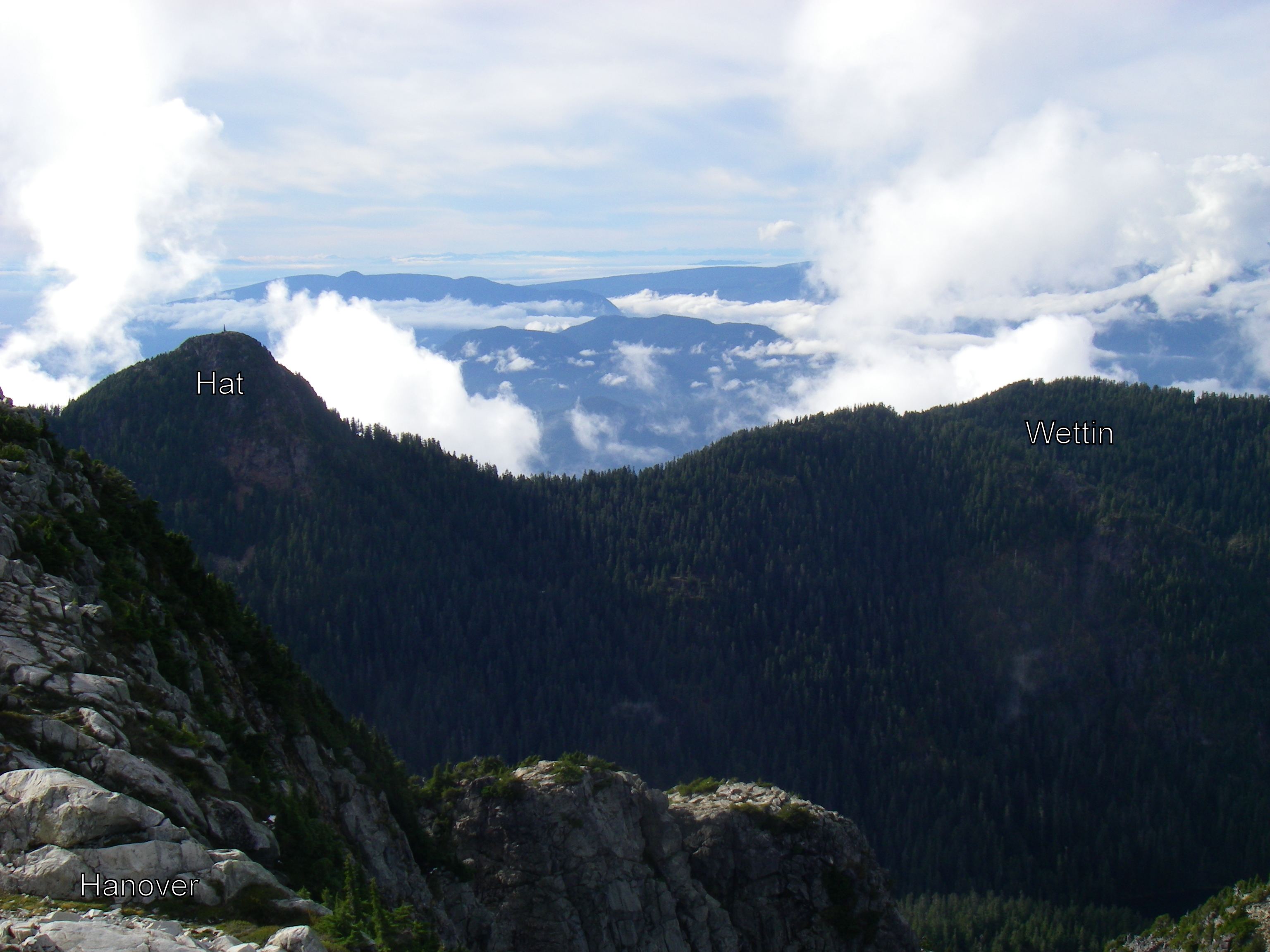
I crossed the HSCT and hiked the easy trail over Fat Ass peak and to the top of Hat. From here the plan was to continue north along the ridge to Wettin. It was 4:00pm by this time as I searched for a route down which bypassed cliff bands and trees glued to the side of the 50 degree slope and obscured the terrain below. In the end I decided there was too much unknown terrain ahead of me and returned the way I had come leaving Wettin for another day. On my return I discovered that the Opencyclemap contour data is significantly less detailed and accurate than the BC trim map data. The terrain I was viewing from the edge of the Hat summit area did not reflect the more moderate view I was seeing on my GPS. The BC trim data does a much better job of identifying the cliff bands. I use a product called Canada Maps by Atlogis on my Android device and it has both map layers available. The BC trim data layer is called Canada Toporama but I hadn't downloaded that data layer and therefore didn't have it available for viewing. Most of the time the cyclemap data is adeqate. I returned to the car at 6:15, almost exacly 12 hours and 25km later.
[[[HAN !!!!!!!!!Mt. Hanover (1748 m) (P: 238m)
HAT Hat Mountain (1644 m) (P: 144m)
CFAFat Ass Peak (1619m) (P: 50m)
BRU Brunswick Mountain (1788m) (P: 1294m)
On Sunday, I headed up the Lions (Binkert) trail to the West Lion. I fumbled around quite a bit finding the correct route up to the top. You quickly find out when you're off route because the grade changes dramatically. Later in the day there are usually so many people on the route that you have no difficulty following it. This year I was one of the first few up for the day and no one else was on the route at the same time I was. I flagged it in a few spots where I had gone wrong on both the ascent and the descent. The correct route is a fairly easy 4th class climb. I next headed for Thomas situated squarely between the West and East Lion. This poor under-rated peak doesn't have Bagger status due to its lowly 30m prominence. From there I headed around another minor bump on the ridge and then over James and David peak. This ridge is very dry so bring plenty of water. I knew about this and had carried my full 1 litre bottle for this trip as opposed the the 1/2 litre bottle I used yesterday. There are significantly more water sources in the Brunswick area. I was able to fill up with snow just south of James and that melted enough by the time I got to the top of David so that I could hydrate sufficiently. The route from David into Harvey pass is poorly marked so I suplemented the flagging here possible. I eventually consumed the last of my first 100' roll of flagging tape. The HSCT trail from Harvey pass to Magnesia pass is surprisingly overgrown with blueberry bushes. In many spots the branches from bushes on both sides of the trail are touching and you can only see the path by looking through them to the ground. The climb up the trail on the east ridge of Harvey is very spectacular. You constantly get the sense that you will be stopped by cliffs but there's always another ledge or way to get through. It's well marked and well used and easy to navigate. I finished the last of my water at the top of Harvey and then headed down via the west side trail. I didn't see fluids again until I got to the road junction heading to Lions bay with a water source at Alberta creek. A fast paced walk and I was back at the car by 5:30, approximately 11 hours, and 20km from the start.
There's Lynn Peak and South Lynn Peak. One is north of the other, but which one is where?
The Lynn Peak that I know is past the viewpoint with the sign and and all that, just around the corner from the trail towards South Needle. The tape on the tree says "Lynn Summit 1000m". Is the other one back somewhere around the viewpoint or is it farther along the South Needle trail or is it somewhere else entirely?
Submitted by Rick Arikado on 6 August, 2012 - 22:04.
Andy
South Lynn is the one you describe marked with tape around tree. The "true" or north Lynn Peak is further north again. N49.39529 W123.01479 - elevation 1021M. As Bill wrote below earlier this year, the trail skirts around the north peak on the east side. You have to bushwack a bit to get there, it is a small outcrop of rock with a cairn. Back on the trail, just after the north peak, the trail dips down to the intersection of the Hydraulic Creek Trail and on to the South Needle.
Here the North Lynn Peak symbol is half cut from the top of the image. The cairn is on the south end of that countour loop, not where the symbol is. The popular viewpoint is the little orange tick at the bottom of the image before the trail heads west. From peak to peak the distance is 1.3K measured in a straight line.
I have yet to reach the real false peak after only making it to the false false peak earlier. So the real real peak would be great, if you know what I'm saying.
Submitted by Rick Arikado on 5 August, 2012 - 19:28.
Not a sweep, just Grouse & Dam today. Clock beat me as I had to get back home, though Goat & Little Goat were right there for the taking. Started at Grouse parking lot, Grind & BCMC were way too busy so hoofed it over to Old BCMC for something different. After the double-bag I was just starting back down via BCMC and made a rare E Greenwood sighting, on her way up. After hellos and quick talk of upcoming Squamish50 exchanged, I am on my way back downhill. I am soaked in sweat again and I realize she didn't even have a bead on her forehead after her climb up!!
Tally GRO & DAM for me Dave, no pics but GPX file is in Dam & Grouse Dropbox folders.
Today's outing was like my last poker game, nothing but bluffs.
The boy and I set out from the Seymour parking lot, made our way past the piles of equipment and supplies that will make up the new ski lift, past the hordes of workers setting up the Warrior Dash and into the bug swarming trail. First on the list was Suicide Bluff, an easy hike with a decent payoff at the top. Nice views and scary drops.
Once back at the gravel road we had a choice to make. Would we get to the DePencier Bluffs trailhead by way of the road or would we go down and take the trail back up again? Neither choice was appealing, so we headed across country. It was a bushwhacking free-for-all. We climbed cliffs, forged our way through assorted brambles and eventually found ourselves high above Mystery Lake. How we got where we were, I'll never know. By the time we got down to the water's edge and sat for a spell checking out the maelstrom of salamanders, we felt like a couple of Bear Grylls'.
We took the trail around the lake and eventually popped out at the ski lift. My hastily scrawled directions told me to look for a narrow, barely visible trail. Hmm... the options were many. We took the wrong barely visible trail and ended up at the top of the lift, looking across at what we thought was DePencier Bluffs. Unperturbed, we descended the wrong hill and in no time found the right trail, all nicely marked with pink flagging. There was some snow and some bear turds, but we made it to the top in no time, unscathed. We sat for a spell, looking at the sights and being generally grateful to live and play in such a beautiful place. Before heading down, the boy dunked his head in a puddle and added a rock to the cairn. Another successful day in the mountains.
Please add to our bagging totals:
DEP de Pencier Bluffs(1230m)
SUI Suicide Bluff(1167m)
ps... The boy respectfully asks to have is name in the standings changed from "Andy Healey's son" to Sam Thorpe.
I am relaying a msg from David, via his wife: "David is away running in the US until Monday -- wanted to let Andy and his son know but I did not have his email. I loved Andy's trip report -- David will definitely change the standings to show Sam's actual name when he is back on line. Nice bagging!"
I (Sibylle) will try right now and put proper name in ;-)
On Saturday I headed up the mountain bike trails of Seymour in search of a route to the Seymour parking lot. Followed Fisherman's, Mystery Creek trail, Powerline trail, TNT, Run Lola Run, and Enquist (aka Cabin trail) before running out of trail. I followed flagging for a while but it was clear that I was now in the bush so headed generally uphill for the last 250m to Mt Seymour Road. About half way up I ran into a well cleared and flagged mountain bike track with lots of new looking structures, bridges, and drops on it. This improved progress significantly. The trail ended in the woods just below the Seymour Works yard at P3 probably due to coverage by winter operations.
From there I headed up to the Suicide Bluffs trail after a brief wrong turn on the First Lake trail. The Suicide Bluff trail is the 3rd turnoff to the west from the Mt Seymour trail and is not signposted. There is a yellow bamboo pole there and 3 rocks across the trail. The trail wanders up and down past danger signs and ropes before reaching the rock outcropping of the summit. It was cloudy so I didn't get much of a view.
Returned from the same point where I had arrived but this time descended the mountain bike trail to its end and flagged any places where it was not well marked. It crossed Enquist and came out on a skid road part way down Run Lola Run. It appears to be a mountain bike trail that's been under construction for a few years with many new structures and difficult drops on it. It's a huge find to have a trail going up the SW flank of Seymour opening up some very interesting future bagging opportunities. Approximate time to the parking lot from Riverside drive is 2 hours.
On Sunday I did a custom variation of Bill (Dave's) Great Peak Adventure which took in Fromme instead of Grouse.
FROMt.Fromme (1185m)
SUI Suicide Bluff(1167m)
Added new Seymour trail, Mystery Creek trail, Suicide Bluff and De Pencier Bluff to Openstreetmap. Also made corrections to Fisherman's, Bridle Path, and Powerline trails.
Excellent find Bill, thank you for sharing, flagging, and adding that unnamed bike trail to OSM.
I ran the Enquist/RunLolaRun area this winter quite a bit, and could not/did not not want to venture too high beyond it in the deep snow. This will make a great Seymour range traverse loop sans roads, using the Perimeter trail for eastern access.
While I'm here, thank you also for the inspiration for the North-Middle-South Needles loop route via Norvan Meadows (props to Craig & Dave too), and for using the wolf-pen to enter the other side of the looking (drinking?) glass.
Monday morning, 6:30, Grouse parking lot is where our adventure begins.
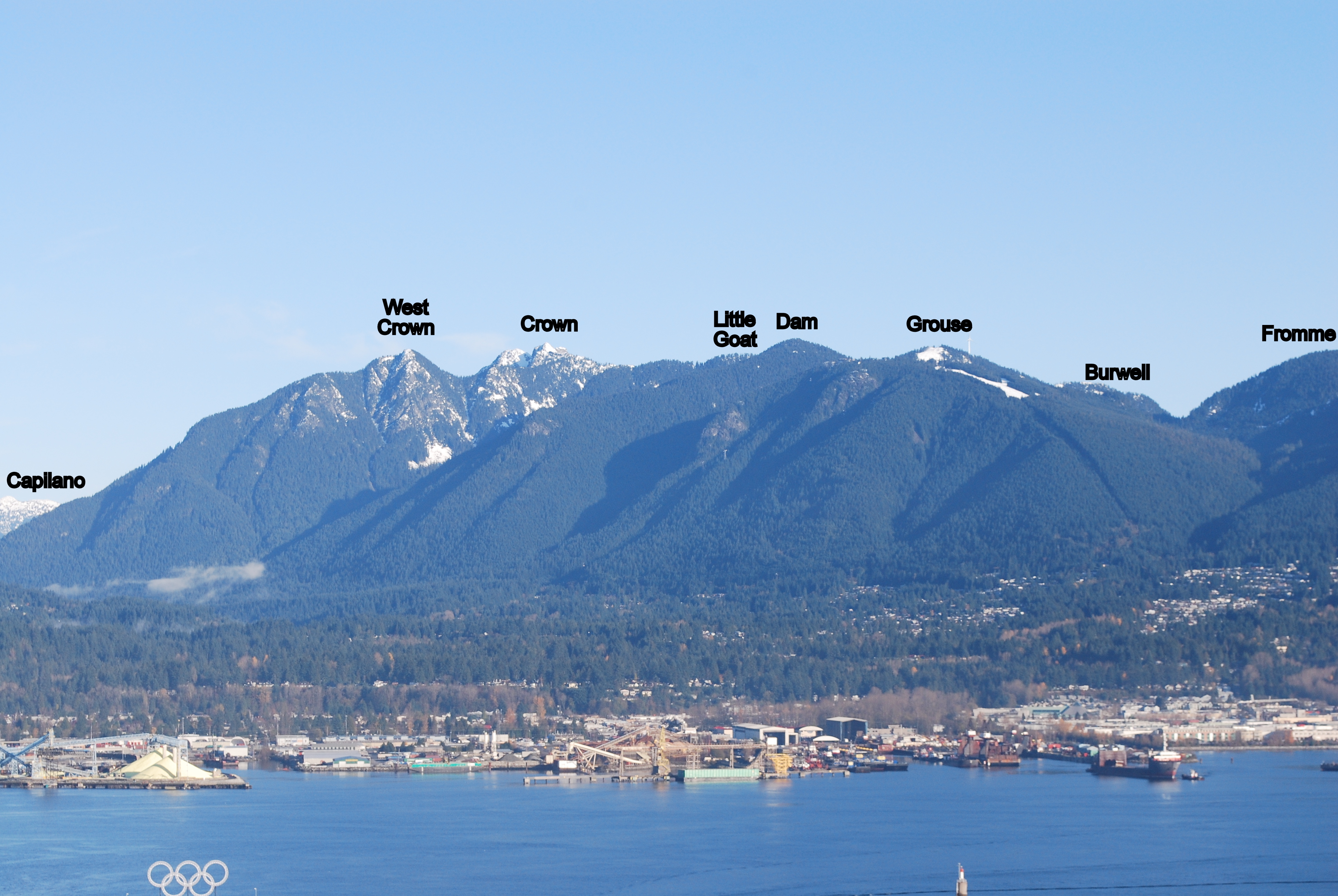
Up BCMC and past the attractions before any tourists had started touring. Headed out along the road beside Grouse and hit the trail toward Goat Mtn. I poked around a bit, looking at the set-up for that zip line business before heading off on the mission at hand. When I got to the turn off for Little Goat, I figured, what the heck and in no time I was up on the top of the Baby Bovid, staring longingly at it's counterpart, Goat Sr.
There was a bit of snow and some slip-sliding with minor leftover postholing, but I eventually made it up past the ropes and chains to the top of Goat. I had a look and pondered Crown, but thought I'd save it for another day.
On the way back, I was passing by the back door of Dam and since I was there, I went up. I'd already laid claim to Dam earlier this season, so this bagging was a double (can we trade these things like hockey cards?). Down Dam, through some puddles and along the pipeline and there I was at Grouse's back door. So up I went.
It's a pretty cruddy scene up there atop Grouse, but it had to be done. I chatted for a minute with the folks setting up the para-gliding operation, but once it became clear that no one was offering to comp me a free para-glide, I set off down the road and back amongst the holiday makers.
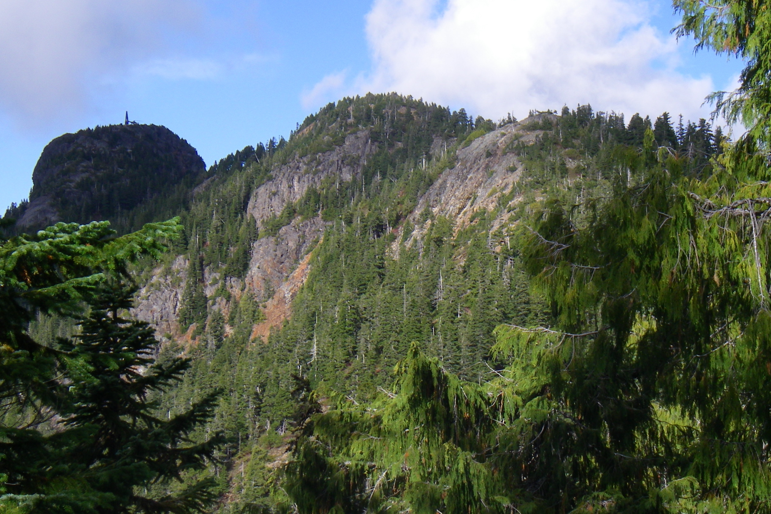
Down the Grouse Mountain Highway to the turn off up that trail just past the "Private Road" sign, what do they call this one? Pipeline? I made pretty quick time to the nice, fake peak of Fromme, Senator Peak, and sat there with a lone grouse for a couple minutes before heading down and then back up to the much more boring South Peak.
From the peak on down to the gravel pit along Bill's Trail was just about the best running of the morning. Soft and bouncy and fast (fast, of course, being entirely relative...). There were a couple NSR guys marking the trail, so your next trip up Bill's should be well marked with some nice, new orange circles.
The end of my morning took me down Peer Gynt, St. George's, BP and then the Powerline and back to the parking lot. Not too shabby if I must say so myself, five peaks in the bag before noon.
Please add to my grand bagging total the following...
I'm fighting some calf problems right now, but I couldn't go another day without bagging a peak. Popped up to Seymour this afternoon and did a circuit to Dog Mt. and back over Suicide Bluffs. Nice to be back at it, even if I did have to fight my way through the tourons.
With a sunny day in the forecast, it was clearly a bagger day, so packed my bag and headed for the Grouse parking lot on Thurs Jul 26. Left the car at 7:15 and entered the Forbidden Forest at the wolf pen. Up and across to Crown Creek following a faint trail that roughly follows the 400m contour. The route crosses Crown creek and heads up the west side to a junction with the Crown Buttress / Crown Pass trail. The Crown Buttress trail soon crosses a boulder field and gains access to the buttress from the east. The route involves some 4th class scrambling on good rock to the summit of Beauty Pk (aka W Crown). There a couple of ropes in place on the steepest sections. It was completely free of snow and dry all the way to the top. I placed approximately 60' of flagging on the traverse to Crown Creek and on the Buttress itself.
From the top of Beauty, the descent crosses wet slabs and snow fields on the way to Crown. Upper Crown ridge is also free of snow at this time. The summit of Crown is probably the most dramatic and awe enspiring vistas of all the bagger peaks and especially in good weather. The descent into Crown Pass was wet and muddy in many places but mostly clear of snow. I passed a group of Europeans that were heading for Crown, the only human sighting this side of Dam. I was wearing hiking boots and had crampons and ice axe in my pack but never used them. The few snow fields I encountered were soft and easy to cross due to the warm weather. The largest patch of snow was on the climb out of Crown Pass and up to Goat ridge.
From Goat ridge I headed north and took the direct trail to the top. The summit rock has orange paint splashed on it. It's a great spot to basque in the sun and I found it hard to keep moving from here. I shared some food with a couple of resident crows and headed on my way as the clock was already showing 5pm and there was still much to do.
Headed back down Goat Ridge, over Little Goat, Dam, and then Grouse itself. It's always such a culture shock when you get onto the road at the top of Grouse and run into all the tourists, most of which never venture more than a few yards from services. They even have the road down from here signposted as dangerous and not recommended for hiking now. Most people get up and down from here via the chairlift.
Couldn't resist stopping at the bear pen and watching them hanging out near the water pond. It was too late to attempt Fromme by this point so I headed back down to the car via the BCMC trail. It had been a long 14 hour day when I arrived back at 9PM.
GRO Grouse Mountain (1231m)
DAM Dam Mountain (1349m)
GOA Goat Mountain (1401m)
LIL Little Goat Mountain (1323m)
CRO Crown Mountain (1504m)
WCR West Crown / Sleeping Beauty (1400m)
In conclusion, there's much less snow this year and it's probably safe to switch to runners now for most of the peaks.
Submitted by Ean Jackson on 23 July, 2012 - 13:34.
One fine day when the monsoons stop, I'd like to do a Needles sweep. Could also involve bagging Lynn and or Patton peaks.
Anyone interested?
I've never been to Middle or North Needle. Curious to know if this is better attempted from south to north or vice versa and why. I figure this is as good a candidate as any for a bike-bag (e.g. ride partway and stash the bikes in the woods.) Ideally, you're one of the rare baggers to have already been there and done that... this so we don't end up camping under tinfoil and being eaten alive by mosquitos when we should be in a comfortable pub celebrating.
Open to mid-week adventures. Recommend an early (e.g. 07:00 or so) start.
Hey Ean. I'm game, but I'm also slow (recovering from injury). I'm currently in the process of putting a few smaller hikes in to test the legs before I tackle anything more. That being said, I should be good to go by mid-to-late August. Let me know if you want company.
It's best to do this route from north to south. It's always better to be standing at the bottom of a cliff looking up with an easily retraceable route rather than at the top looking down with a not so easy to retrace route. Although not well flagged its much easier to find the correct approach when ascending from Norvan falls. See Craig's writeup from a few weeks ago.
The best way to do the Needles is as a loop starting from the Lynn Creek trailhead, ascending via Norvan falls, then up and over North, Middle, and South needle, and then continuing along the ridge over Lynn and South Lynn peaks and descending back to the start via the Lynn peak trail.
It's a pain to shove two bikes into the back of my car, so the boy got a bike and I went with his skateboard. I hadn't ridden a skateboard in about twenty years, but muscle memory is a powerful thing and in no time we'd gone the 5.5km down the Seymour Valley Trailway to the Hydraulic Creek trailhead. We then proceeded to slog it on up. The trail is really well marked, we had no trouble getting to the top. The bugs up on the summit were ruthless, so we didn't stay long, just long enough to wolf down some peanut butter and honey sammies and take in the crazy 360º views.
(At the top of South Needle, one of us was a bit fresher than the other. I'll let you guess who was who.)
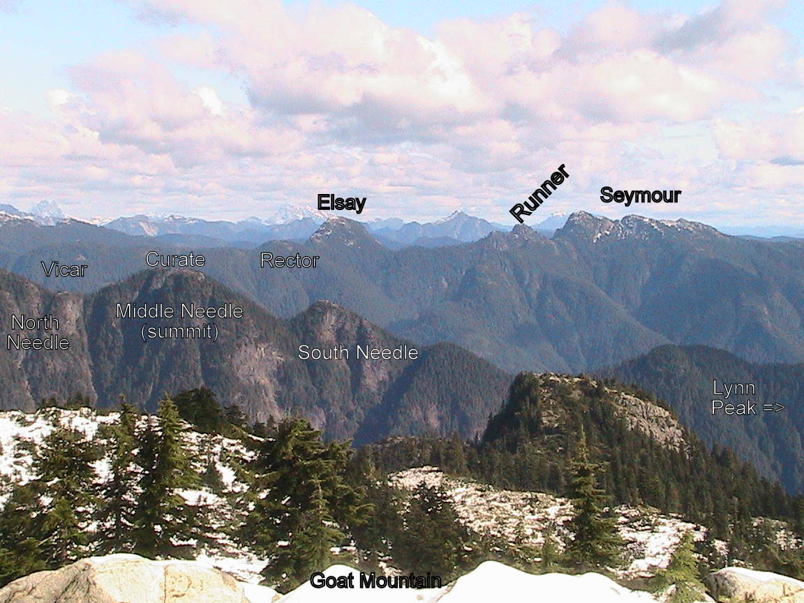
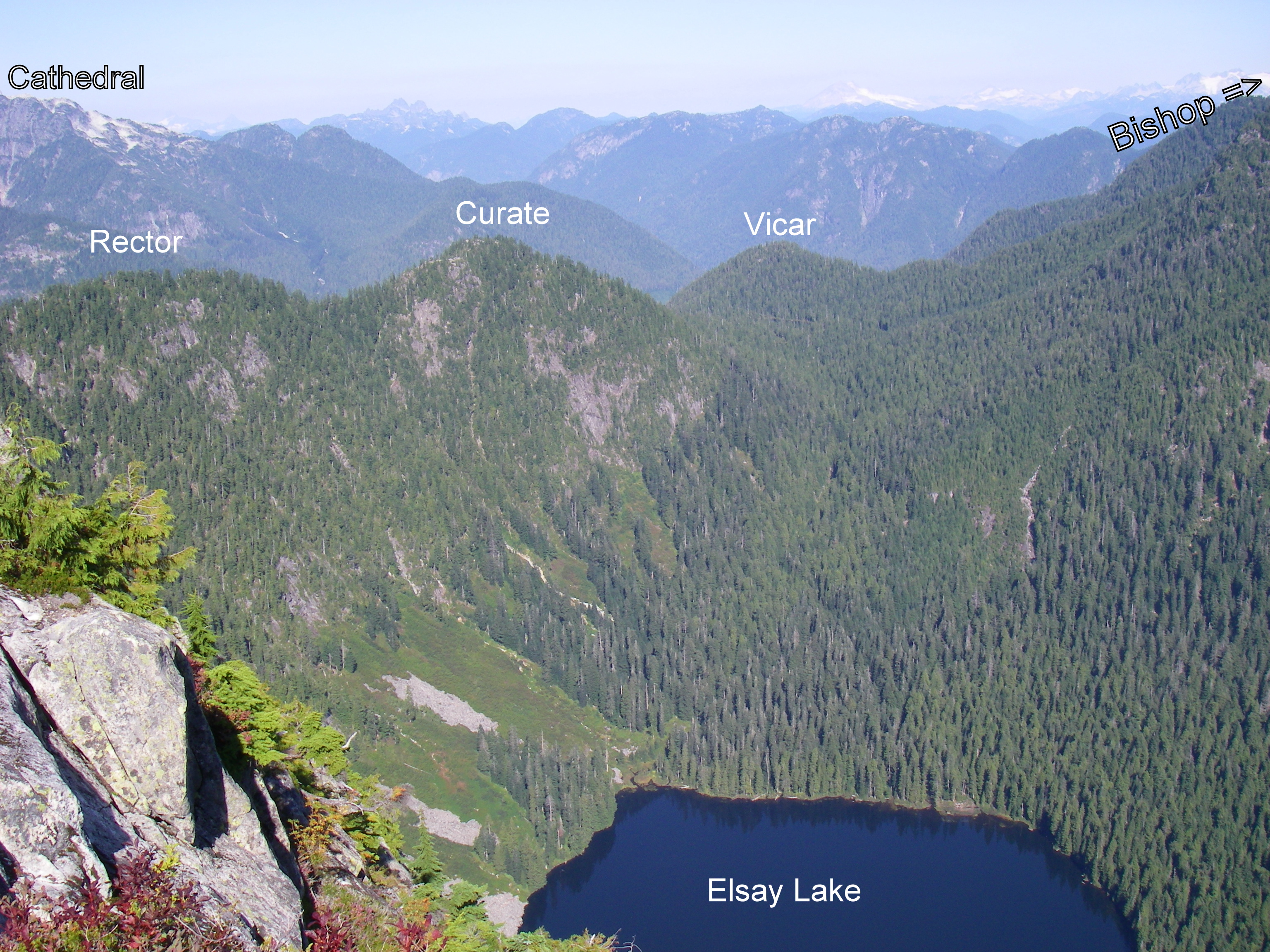
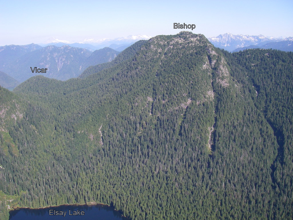
Headed up to the Seymour parking lot on Saturday morning in sunny weather on Sat Jul 7. The old Mystery Peak chair is gone as they prepare to install a new high speed quad in time for the next ski season. Headed up to DePencier bluff and fumbled around a bit trying to find it. It's the smallest bump at the end of the ridge and a case where prominence is not very intuitive. All the higher peaks in the area (Mystery, Brocton, Pump, and Second) have less prominence but appear more significant. The mosies were aready quite annoying. Headed over the shoulder of Pump and noticed Runner and Elsay in the distance. After a brief break on top of Seymour, I put on crampons and headed around the west side trail to Runner. There was just enough old flagging to make it fairly easy to follow the route but is in need of more. Next trip I'll definitely bring some to assist with the bagging initiative. On the way up the south side of Runner I noticed the hole that had swallowed Adventure Mike during the last bagging season, looking much smaller and more subdued. Then the long traverse around Runner and up Elsay. A slight route mis-calculation brought me into a short section of technical rock on the west ridge leading to the summit. Another break before the long slog across Rectar, Curate, and Vicar. Much easier with snow over the bush at this time of the year but nevertheless a long out and back with lots of ups and downs. Like the Lynn/Needle ridge, the most aesthetic circuit likely involves traversing the ridge once and going the opposite direction in the valley bottom. It might add a bit more time but would contain much more runnable terrain. Nice sunny skies all day with a brilliant crimson sun in the evening. I was planning to do Suicide Bluff on the return but it was 9:45pm by the time I got to the trail junction with daylight quickly fading. I'll do it during a recce of the start of the bigger loop which will start at the end of Riverside, go up Fisherman's, Bridle Path, Hyannis, TNT, Run Lola Run, and Enquist in the hopes of popping out somewhere near the Mt Seymour Parking lot. The descent (next year) from the end of Vicar ridge will be via the Vicar Lakes trail, East Spur road, and Fisherman's.
A little late joining the party ... but finally bagged my first peaks of the season. This morning did Black (Cypress Bowl-Black Mountain-Eagle Bluff-return). Then this afternoon under sunny skies my daughter Ariel and I took the gravel road from the chalet up to the peak of Grouse for her first ever bag. Her words at the top were "I want to hike up 6 mountains this summer because I'm 6 years old". I hope she maintains her enthusiasm even once she realizes that unlike at the Grouse summit, you generally aren't able to buy a popsicle at the top of a peak.


Comments
I'd Take on Hannover if it was on Sunday
Hey Jackson,
I'd be willing to take on Hannover if you could go on Sunday.
From what I've read about
From what I've read about Hanover, Ean, not sure I trust myself to not a) break my neck on the Hanover scramble; or b) kick a big rock into someone's else neck. Maybe if I just stood at the base of the gully with a net or giant catcher's mitt to catch any flying debris and/or flying fatasses...
Brunswick & Brunswick
One of my favorite outings of 2011 was to the top of Mt. Harvey, so I looked forward to going back to the same neck of the woods on Saturday to bag neighbouring Brunswick Mountain, elevation 5,866 ft. If all went smoothly I’d pick up Fat Ass and Hat at the same time. Arrived at the tiny Lion’s Bay parking lot on Sunset Drive at 7:15am and fortunately was only the 2nd car there.
Headed up the same wide gravel road as to the Lions Trail, turned left at the colorful sign marker around 20 minutes in. The remainder of the first hour or so was on a beautiful runnable trail that wasn’t technical and that varied in width from that of a narrow road to double track. A joy to run on. Wet leaves and bush that hugged the trail at times and slapped you as went by was only a minor irritant. You first run past Magnesia Creek, which was easy to walk over with only the slightest foot splash. Moments later turned upwards at the blowdown spot where the Hat/Tunnel Bluffs Trail keeps going. The elevation gain was slight for stretches so you knew you were only delaying the inevitable, with a few thousand feet of gain still to come, but was easy to ignore that and enjoy the good trail while it lasted. The trail did of course get steeper eventually and any running slowed to a hike for me, but the cool weather was ideal for the climb upwards.
The Brunswick Trail after awhile intersects with the Howe Sound Crest Trail when you’re almost at 5,000 ft of elevation. This is a fantastic 4-way junction. Good choices all around – up to Brunswick Mountain, down to Lion’s Bay, left to Brunswick Lake, right to Magnesia Meadows. Decisions, decisions. At this point I still hadn’t seen a soul all day, and so high above civilization you feel the area is practically your own private playground.
The work picks up somewhat, as you make your way up more steeply now past pointy rocks and with quite loose gravel underfoot slowing you down a bit. Route very easy to make out though. Given the cloud cover which dropped visibility close to nothing, I naively thought I might be taking my final steps to the Brunswick summit but in fact soon learned it was only to be the saddle/ridge. It’s then probably only another 500m or less to the summit but there were steep slopes (especially to the left into a snowfield bowl) off of the narrowing ridge and I found it rather nervy going for awhile so made my way gingerly. The more confident and sure-footed among you would have no issue with it, but I’m neither. So this was a good time to suppress my clumsy side. Having said that, it wasn’t really too difficult of a scramble, there was no rush, I managed.
The views from the peak are reportedly breathtaking. Howe Sound, the Lions, Deeks Lake, Garibaldi, etc. I couldn’t see a thing. One mountain poked out, I’m guessing it was Hanover. A part of another mountain, likely Harvey, appeared for a moment in the other direction but in the 30 seconds it took me to unzip my pack, take out my iPod Touch for a photo, and aim in that direction to capture the eerie scene it had vanished.
Back at the intersection, I headed towards Brunswick Lake but missed the trailhead at Hat Pass for Fat Ass Peak and Hat Peak. I wasn’t looking closely enough – I now understand that it was near the tarn that you pass around 1/3 of the way to Brunswick Lake from the 4-way junction. Soon I was losing elevation so I knew I had gone too far but ending up at Brunswick Lake is never a bad consolation prize. Encountered my first four humans of the day, filled up with water at a creek approaching Brunswick Lake, flipped through the logbook at the Brunswick Lake emergency shelter, and dropped my gear to stroll down the lake shore to relax for a bit. Then back up to the junction and then the long downhill, most of which you could really blast if you so choose, back to the now full parking lot. Time out, including the breaks at the peak and the lake, was a shade under 6 hours.
An hour after my return to the parking lot I was home, showered and back out to T&T experiencing the culture shock of going from the solitude of the upper trails to jostling for coveted moon cakes with dozens of shoppers.
An 0-fer on the views and a 1 for 3 on intended baggage, but a memorable excursion that I’ll most likely repeat next year.
de Pencier
Bill posted way below our adventure bagging de Pencier. Not sure if it was caught or not, but we did it on Saturday. DEP for Bill and Jess (and Sierra). Cheers
Pro-D Day Bagging Adventures.
Today was one of those days dreaded by peace and quiet loving parents, yet loved by eleven year olds everywhere, the Professional Development Day. Since the boy wasn't in school, I decided to play hookey from the job and take him up to the fresh air for some peak bagging adventures.
It was a grey, cloudy day but we made the best of it. Up the BCMC, then onward to Little Goat, Goat, Dam and Grouse. It was a shame that there were no views, but we got to see Crown looming above the mist, so that was nice.
We met a guy on Little Goat who had seen a cougar there, right in that little meadow, last week. We had no such luck, although there would be lots of "would you rather" talk the rest of the day involving various beasts and predators and what we should do if we encountered them. Any opportunity for a learning experience... the boy's teacher would have been proud.
In conclusion, Sam Thorpe hereby lays claim to:
Be careful out there: the summer party is over
http://bc.ctvnews.ca/hikers-warned-to-be-cautious-as-weather-changes-1.968518
Friday Fromme
This past Friday was the first dreary day in Vancouver after a glorious stretch of sunny mild weather, but I decided to bag Fromme regardless. Last year I had done Fromme by following Bill's Trail up from the quarry off of Old Mountain Highway, so I decided to mix it up with a different route this year. I made killer time at the beginning, storming up a 3,000 ft ascent in only 8 minutes.
My surprise reward after getting off the Skyride was sunshine and relative warmth, as we had popped through the clouds. Jogged downhill on the logging road for around 15 minutes before taking the Pipeline Pass trailhead on the left, then turned right to Fromme at the well-marked junction a few hundred feet in (made a note of it for my return). Neat perspective from both the north (Senate) and south (true summit) peaks of Fromme, as the cloud level was about 200 ft below the Grouse Chalet so all you could really see in any direction were peaks poking out like islands. Back down, at the Pipeline Pass junction turned right onto the Erik The Red Trail, flattish for a short while, descended down to a creek and then back up towards the Thunderbird Ridge trail. You end up on the Alpine Trail for its 2.2km path back to the chalet.
I couldn't help but gloat a little after having enjoyed the sun while Vancouver was grey the entire time, but I should have known not to do so as the next day the tables were turned on me ...
Suicide Solution
I had thought of bagging Suicide Bluffs when I bagged Seymour and DePencier a couple of weeks ago but deferred. It’s just as well, because it became a nice little bagging trip on its own on a pleasant late summer day last week. In fact, along with Hollyburn via the Cypress downhill parking lot, I think this may become a preferred route of mine when a friend or client with some trail running or hiking experience comes to Vancouver and wants an introduction to a North Shore peak that could be done in well under 2 hours after work.
Unless you have time constraints or are tacking this onto other Seymour area peaks as part of a longer day, I’d recommend the Seymour downhill parking lot-Dog Mountain trail-Suicide Bluffs-Seymour Trail-parking lot loop as David suggested. The loop I’d estimate adds a half-hour or so compared to if you just did an out and back from the trailhead off of the main Seymour trail, but it is more interesting and still one of the quicker bags.
The views from Dog Mountain including back to the city make for a worthwhile 5-minute detour (the trail to Suicide Bluffs heads off north from the Dog Mountain trail just a few minutes before the top of Dog Mountain), then the trail becomes a bit rougher and less-travelled but still very pleasant to the Bluffs. Coming down from the Bluffs and running east, I encountered a friendly group of 10 picnickers from overseas and after declining a politely-offered pickle sandwich I was soon at the main Seymour Trail. Like a couple others have written, while the Dog Mountain trail cannot be missed, if you choose to take the more direct route then the trailhead off of the main Seymour Trail is clearly visible but unmarked – if after starting from the parking lot you reach Brockton Point you’ve gone too far.
This is a welcome new addition for 2012 to the Bagger Challenge peak list.
Saw more.
Had a nice time up on Seymour yesterday. It was sunny and warm and I got there before the school bus full of teenagers, so that was good. Did some wandering around and scrambling on various nooks and crannies on the way down. Everyone I met heading back told me to beware the bear, but I missed him altogether. I thought to go back today and have a crack at Runner Peak but I've got a sick kid, so Runner will have to wait for some other sunny day.
SEY Mt. Seymour (1449m)
kid-bagged Black
I bagged BLA with Isaac White yesterday. Isaac is a much stronger hiker this year, what a difference a year makes. Last year it took him over an hour to reach the top, this year only 39 minutes as a 6-year old.
Grouse Peak bag via BCMC
Bill carried Sierra today...nice break for me! Bill already has Grouse, but I didn't until today. Thanks!
Lionsbay Trailhead Closed..
Just an FYI the main trailhead from Lionsbay is still closed 'until further notice' after the fire last week. Not sure about the one that heads up unnecessary mtn but likely the same..
Deeks, Windsor, Corburg & Hanover will have to wait.. :(
Open again ..
Did the West Lion yesterday and the trail from Lions Bay is open again!
Hollyburn Diaper Bag
Took Sierra up Hollyburn today. Beautiful! Cheers
awesome photos!
Good job starting her young! She will love nature (and not whinge about hiking when older).
Bagging vacation
thanks for the news!
We thought that you were stuck on Mt Dickens.
Happy cycling,
DAC
Bagged Fromme as a Custom Route during the MHM today
Little foggy up there too, but Bill's trail from the gravel pit to the top is pretty much double marked all the way.
I heard the North Shore Rescue folks just put on some new markers there while guiding someone back down. Did they ever do a good job on that one.
My adventures this year are hardly of epic proportions, but for the time being I am on track for my sweep by the time I'm 45 (10 years). Pretty generous timeframe, I know.
By then the kids will be old enough so I can resweep a little faster.
Crown.
Now that school's in session, peak bagging takes a backseat to parenting. With all these piano lessons, swimming lessons, soccer games and whatnot my bagging adventures must be held between the hours of 9am-3pm on days when I'm not slaving away at my gruelling three day work week. I'm pretty much only good for Thursdays and Fridays now.
The race was on. Could I get the boy breakfasted and off to school, battle rush-hour bridge traffic, get up the BCMC, then Crown, back down BCMC and back over the brigde by 3:00?
Yes, it turns out, I could. Almost. My tired legs and ticking watch forced me to break my golden rule of "Thou Shalt Not Pay To Get Off Thy Mountain" and I took the gondola down. All else went nice and smooth, other than a couple serious don't-look-down moments on the final push to the summit. I saw no human beings from the Grizzly Bears until I was on the return trek up from Crown Pass. It was a very nice day.
CRO Crown Mountain (1504m)
Sunday September 9
Anyone interested in a bagging adventure this Sunday, probably heading out towards Elsay and maybe beyond, exact destinations will depend on the enthusiasm group. Stetson has seen that Tundra is pulling ahead......
Dustbags
Eric Rannaud and I successfully bagged SNE, MNE, NNE and lastly LYN via Hydraulic Connector yesterday from 7am to 5pm. We needed both of our brains to solve some tricky route-finding beyond SNE to the north, and especially to pick the safest scrambling routes. There's little flagging beyond SNE. Several first impressions of "ok, guess we'll turn around here" were reversed when we found the safe route down (or up). One such passage was a tunnel under some blueberry bushes. The dry and dusty conditions provided great traction the entire day. The brilliant daylight was also helpful. We encounterd no mud or snow and would not recommend SNE to MNE to NNE if any snow or ice is present. The saddle between MNE and NNE is something to behold - treed and filled with bushes but only about 10 meters wide with a sheer drop to the East and rapid descent to the West. Aside from the usual scratched legs and arms, and a shredded pair of thick leather workgloves (they did their job, protected my hands perfectly), it was an adventure we'll not soon forget. Photos to follow.
Congrats Bill!
Coliseum and others.
First, some housekeeping. Earlier this year, I had claimed Lynn Peak only to find out that I hadn't actually been on the true peak, just the lowly South Peak. I set out this morning to rectify my error.
Up Lynn I went and once again found myself at the familiar South Peak (SLY). The pink tape that had been around the tree was on the ground and a little chewed up, so I did my best to get it back in it's rightful spot before heading down towards the Needles and the real Lynn Peak. The trail is immediately steep and it set the tone for the rest of my day. After some ups, downs and a pile of blowdown, I see a tree with some tape marked "Middle Peak 1015m". This must be it. I remembered hearing that the actual summit was off the trail, so I looked up and then I went up. Some minor bushwhacking and crawling over rocks and I found it. Put a rock on the cairn and set sail for Hydraulic Creek.
Down the Hydraulic Creek trail to the paved Seymour Valley Trailway was nice. It's steep and runnable in spots, I did what I could. If memory serves me, the trail for Paton would be at 9km. Or was it 9.5km? And what was I looking for again? I ran to the 10km marker and turned around. This time I went slower and peeled my eyes for some sort of flagging. I found some pink flagging and headed into the woods. There was steep hills and lots of bush to be whacked, but no trail. After far too long poking around to no avail, I gave up. On my way back to the start of the paved road, I saw a paved turnoff heading uphill. I followed it and it soon became a dirt road, which soon became a wide trail. At the top there was what appeared to be a real trail with some NSR flagging, so I went in and up. This must be the way to Paton Peak, I surmised. It was steep and it went on and on. Eventually I found myself on the top, put a rock on one of the many cairns and sat down to eat the peanut butter and the jam. I was beat and thought about calling it a day, but the thought of going down that steepness and then running a 10k on the road spurred me on to bigger and better things.
After heading down off Paton, it wasn't long until I was climbing again. Up, up, up... Eventually there was a boulder field and beyond that I was in familiar territory. The trail from the boulders spits you out on the trail just about at the final push to the top of Coliseum. Pretty exhausted and almost out of water, I did the sensible thing and kept going up. I got to the top of Coliseum, had a look around, slapped myself in the face when I started thinking about Burwell and set sail for home. It's been a couple years since I've been on Coliseum and I'd forgotten how long the return trip is. Down, down, down...
In what felt like half a lifetime I was on the Headwaters Trail and it was smooth sailing all the way back to the start.
9 1/2 hours, sheesh...
Great news re. Mt Bishop/Vicar Lakes Trail
http://www.clubtread.com/sforum/topic.asp?TOPIC_ID=51530
Sunny weather equals lots of baggage
With more good weather in the forecast Linda Malek and I headed for Gambier and Mt Killam on Fri Aug 10. It had alluded me on the Gambier sweep and just needed to be done. We caught the 7:25 ferry to Langdale and the Stormaway to New Brighton with a perfect connection. The trail was well marked although that didn't help us miss it a few times with all the chatting that was going on. Round trip was 5.5 hours at walking pace and distance was 16km.
The return ferry connection was not nearly as good. The schedule has the Stormaway returning from New Brighton to Langdale at 3:25, exactly the same time that the Langdale ferry returns to Horseshoe Bay. We enjoyed the good gelato ice cream at the Langdale kiosk while waiting an hour for the next sailing.
On Saturday, it was time for the Cypress sweep which I was accompanied on with my daughter Annie. We started at 7AM heading east on the BP to the cross country area where we turn north at the Hollyburn trail junction. Then over the top in a northerly direction to the downhill area and the Strachan trail which goes up through the woods just east of the downhill run. We crossed the location of the 1963 T-33 crash site with lots of wreckage still visible. We'd missed this on last year's sweep when the area was still covered in snow. It's located at an elevation of 1310m. From Strachan we headed down the west gully between it and the top of Sky chair to the HSCT. Then up to Saint Marks summit. There is a sign posted "Saint Marks Summit" which is not actually the summit but the viewpoint. The summit is another 40m higher up and can be accessed via a faint trail on its north side. It is a bushy summit with no view. Next we headed for Unnecessary ridge to resolve the mystery of the real peak. There are in fact three peaks on the ridge with the southern one being the lowest, the middle one being the highest, and the north one being 10m lower than the middle one. That means you don't have to go to the north one when doing this sweep although it is the best place to take an unobstructed picture of the Lions. On the return, I ran back, bagged Black, and met Annie in the parking lot. The real Black Mountain is to the north of Cabin Lake although for the purposes of the Challenge and the KK folks, the south summit is also considered a "Black bag".
On Sunday, it was once again time to do the dreaded Cathedral sweep. Not having found any willing partners (guinea pigs) this would be another solo sweep. Left the house at 6AM on my mountain bike and managed to get to km 9 of the LSCR recreational pathway by 7AM which is the trailhead. Headed up the steep but well flagged trail to Paton Viewpoint and arrived just dripping with sweat from the hot humid conditions. Then headed up to Colliseum and over to Burwell. I passed a few people that had camped in the summit area but after that I was on my own. There were only scattered snowfields remaining on the north slope of Burwell as I made my way down to the pass between Pallisade and Burwell Lake. I made sure to fill up my water bottle at one of the many streams that were supplied by the melting snow. At first the going is easy but as you cross the pass the bush becomes thicker and thicker and the route only sporadically marked. I was following the track on my GPS which I thought was the route we had followed last year but in fact was hand generated. When I reviewed the notes from that trip, I wrote "Not sure what happened, but my Garmin lost the GPS track for this trip". Too bad I didn't realize that sooner. At an elevation of around 1300m the hand drawn route took me right over a cliff band. I managed but it got interesting with some fancy moves on trees that were just pasted to the side of the cliff. Higher up I ran into some sporadic flagging which improved progress considerably. I suplemented it with a lot more of my own and both the ascent and descent but only on the upper half of the mountain when I was sure I was on the correct route. Don't get the impression that there is a path here because a lot of the lower half of the mountain is just a route through bush.
I got to the top at 2:50 and just enjoyed the sun and view at the top for over an hour. There are nice decks connected to each of the towers. It was just after 4:00 when I headed down. There were some route finding complications as I negotiated the various bluffs but I flagged them as best I could. There is already a fair amount of flagging in this upper section. I found a better route down in the 1300m zone but once again lost any sign of flagging and ended up crossing steep terrain. In retrospect I should have been further south. It was getting late and looked like I would be running out of light when I discovered that I had left my headlamp in my other pack. Great! Managed to get down to near Paton viewpoint by nightfall at 9:00pm. I had a pile jacket and hat with me and it had been a warm day so I lay down in the woods with the mossies and flies and had a light sleep interrupted by a lot of shivering. Most of the bugs went to sleep as it got dark too so it wasn't too bad. Managed to see enough to start moving by around 5:15 and was home in bed by 7:30.
They don't call this the Bagger CHALLENGE for nothing! I just know I can do it better next year.
Corrected the OSM route for Cathedral.
This wheel's on fire!
Only 12 more to go.
Suicide Bluffs and De Pencier Bluffs
Biked up to the Seymour parking lot this morning to bag the two bluffs.
It was a great day to be out.
Thank you very much to Bill Maurer for posting links and waypoints and therefore pointing newbies like me in the right direction. It can often times make the difference between an uninspired scramble and a successful bag ... or two.
Sweeps from Lions Bay
Did 2 sweeps from Lions Bay on Saturday and Sunday. Got to the Lions Bay trailhead parking spot at 6:15am on both days, an assured time to get one of the six available non-resident spots there.
On Saturday headed up the Brunswick trail. Since it's a westerly approach it was nice and cool on the way up. Didn't hit the sun until I got near the summit of Brunswick at 9:10am which was perfect. It seemed like this might be an easier sweep to incorporate Hanover into than the Deeks sweep so I headed down the HSCT to the Brunswick cabin and then Brunswick Lake. From the south end of the lake I followed creek drainages through relatively open territory to the base of the 2 gullies on the SW side which lead to the summit. I took the right one as advised in numerous sources and soon found myself at the base of the first 2 chockstones. I climbed part way up and soon found myself facing a fairly uncomfortable 4th class move. For those not familiar with the grading system, 4th class means "rope up beginners, exposed, a fall will result in serious injury or death". Being solo always seems to add a bit of drama of these moves. I got over this 30' section without a huge sense of relief realizing that I would have to reverse it on the way down. There was a small amount of snow in the gully but nothing that caused problems with the runners. Then up over the second chockstone which was a bit easier and I was soon on top. First time on Hanover. I headed back down and got similarly gripped decending the chockstones. A couple of pieces of webbing or rope would simplify the danger significantly.
On the return I headed straight cross country towards Hat Pass flagging the route along the way. I rejoined the HSCT at the exact spot of the Hat trail junction. If you're coming from Brunswick heading north along the HSCT you turn left (north) to go to Hat or right (south) to go to Hanover. After a short distance of 100m or so you turn down a creek drainage that heads in an easterly direction towards Hanover and then cross open country to a creek drainage coming off the SW side of Hanover.
I crossed the HSCT and hiked the easy trail over Fat Ass peak and to the top of Hat. From here the plan was to continue north along the ridge to Wettin. It was 4:00pm by this time as I searched for a route down which bypassed cliff bands and trees glued to the side of the 50 degree slope and obscured the terrain below. In the end I decided there was too much unknown terrain ahead of me and returned the way I had come leaving Wettin for another day. On my return I discovered that the Opencyclemap contour data is significantly less detailed and accurate than the BC trim map data. The terrain I was viewing from the edge of the Hat summit area did not reflect the more moderate view I was seeing on my GPS. The BC trim data does a much better job of identifying the cliff bands. I use a product called Canada Maps by Atlogis on my Android device and it has both map layers available. The BC trim data layer is called Canada Toporama but I hadn't downloaded that data layer and therefore didn't have it available for viewing. Most of the time the cyclemap data is adeqate. I returned to the car at 6:15, almost exacly 12 hours and 25km later.
On Sunday, I headed up the Lions (Binkert) trail to the West Lion. I fumbled around quite a bit finding the correct route up to the top. You quickly find out when you're off route because the grade changes dramatically. Later in the day there are usually so many people on the route that you have no difficulty following it. This year I was one of the first few up for the day and no one else was on the route at the same time I was. I flagged it in a few spots where I had gone wrong on both the ascent and the descent. The correct route is a fairly easy 4th class climb. I next headed for Thomas situated squarely between the West and East Lion. This poor under-rated peak doesn't have Bagger status due to its lowly 30m prominence. From there I headed around another minor bump on the ridge and then over James and David peak. This ridge is very dry so bring plenty of water. I knew about this and had carried my full 1 litre bottle for this trip as opposed the the 1/2 litre bottle I used yesterday. There are significantly more water sources in the Brunswick area. I was able to fill up with snow just south of James and that melted enough by the time I got to the top of David so that I could hydrate sufficiently. The route from David into Harvey pass is poorly marked so I suplemented the flagging here possible. I eventually consumed the last of my first 100' roll of flagging tape. The HSCT trail from Harvey pass to Magnesia pass is surprisingly overgrown with blueberry bushes. In many spots the branches from bushes on both sides of the trail are touching and you can only see the path by looking through them to the ground. The climb up the trail on the east ridge of Harvey is very spectacular. You constantly get the sense that you will be stopped by cliffs but there's always another ledge or way to get through. It's well marked and well used and easy to navigate. I finished the last of my water at the top of Harvey and then headed down via the west side trail. I didn't see fluids again until I got to the road junction heading to Lions bay with a water source at Alberta creek. A fast paced walk and I was back at the car by 5:30, approximately 11 hours, and 20km from the start.
Where is the other Lynn Peak?
There's Lynn Peak and South Lynn Peak. One is north of the other, but which one is where?
The Lynn Peak that I know is past the viewpoint with the sign and and all that, just around the corner from the trail towards South Needle. The tape on the tree says "Lynn Summit 1000m". Is the other one back somewhere around the viewpoint or is it farther along the South Needle trail or is it somewhere else entirely?
Thanks.
Head North
Andy
South Lynn is the one you describe marked with tape around tree. The "true" or north Lynn Peak is further north again. N49.39529 W123.01479 - elevation 1021M. As Bill wrote below earlier this year, the trail skirts around the north peak on the east side. You have to bushwack a bit to get there, it is a small outcrop of rock with a cairn. Back on the trail, just after the north peak, the trail dips down to the intersection of the Hydraulic Creek Trail and on to the South Needle.
Here the North Lynn Peak symbol is half cut from the top of the image. The cairn is on the south end of that countour loop, not where the symbol is. The popular viewpoint is the little orange tick at the bottom of the image before the trail heads west. From peak to peak the distance is 1.3K measured in a straight line.
Thanks!
Awesome. Thanks Rick, I'll find that sucker yet!
I am with you
I have yet to reach the real false peak after only making it to the false false peak earlier. So the real real peak would be great, if you know what I'm saying.
Maybe a Sunday in early September?!
Hope you had a good race in Squamish.
Double bagger
Not a sweep, just Grouse & Dam today. Clock beat me as I had to get back home, though Goat & Little Goat were right there for the taking. Started at Grouse parking lot, Grind & BCMC were way too busy so hoofed it over to Old BCMC for something different. After the double-bag I was just starting back down via BCMC and made a rare E Greenwood sighting, on her way up. After hellos and quick talk of upcoming Squamish50 exchanged, I am on my way back downhill. I am soaked in sweat again and I realize she didn't even have a bead on her forehead after her climb up!!
Tally GRO & DAM for me Dave, no pics but GPX file is in Dam & Grouse Dropbox folders.
Thanks
Rick
Little Goat, Goat and Dam
Beat the Sunday crowds this morning for one of the more popular triple headers.
Thanks Andy for the guided Tour.
Tour de Bluffs.
Today's outing was like my last poker game, nothing but bluffs.
The boy and I set out from the Seymour parking lot, made our way past the piles of equipment and supplies that will make up the new ski lift, past the hordes of workers setting up the Warrior Dash and into the bug swarming trail. First on the list was Suicide Bluff, an easy hike with a decent payoff at the top. Nice views and scary drops.
Once back at the gravel road we had a choice to make. Would we get to the DePencier Bluffs trailhead by way of the road or would we go down and take the trail back up again? Neither choice was appealing, so we headed across country. It was a bushwhacking free-for-all. We climbed cliffs, forged our way through assorted brambles and eventually found ourselves high above Mystery Lake. How we got where we were, I'll never know. By the time we got down to the water's edge and sat for a spell checking out the maelstrom of salamanders, we felt like a couple of Bear Grylls'.
We took the trail around the lake and eventually popped out at the ski lift. My hastily scrawled directions told me to look for a narrow, barely visible trail. Hmm... the options were many. We took the wrong barely visible trail and ended up at the top of the lift, looking across at what we thought was DePencier Bluffs. Unperturbed, we descended the wrong hill and in no time found the right trail, all nicely marked with pink flagging. There was some snow and some bear turds, but we made it to the top in no time, unscathed. We sat for a spell, looking at the sights and being generally grateful to live and play in such a beautiful place. Before heading down, the boy dunked his head in a puddle and added a rock to the cairn. Another successful day in the mountains.
Please add to our bagging totals:
ps... The boy respectfully asks to have is name in the standings changed from "Andy Healey's son" to Sam Thorpe.
Great hike and write-up.
Great hike and write-up.
Hi Andy and Sam, I am
Hi Andy and Sam,
I am relaying a msg from David, via his wife: "David is away running in the US until Monday -- wanted to let Andy and his son know but I did not have his email. I loved Andy's trip report -- David will definitely change the standings to show Sam's actual name when he is back on line. Nice bagging!"
I (Sibylle) will try right now and put proper name in ;-)
Suicide Bluff and Fromme
On Saturday I headed up the mountain bike trails of Seymour in search of a route to the Seymour parking lot. Followed Fisherman's, Mystery Creek trail, Powerline trail, TNT, Run Lola Run, and Enquist (aka Cabin trail) before running out of trail. I followed flagging for a while but it was clear that I was now in the bush so headed generally uphill for the last 250m to Mt Seymour Road. About half way up I ran into a well cleared and flagged mountain bike track with lots of new looking structures, bridges, and drops on it. This improved progress significantly. The trail ended in the woods just below the Seymour Works yard at P3 probably due to coverage by winter operations.
From there I headed up to the Suicide Bluffs trail after a brief wrong turn on the First Lake trail. The Suicide Bluff trail is the 3rd turnoff to the west from the Mt Seymour trail and is not signposted. There is a yellow bamboo pole there and 3 rocks across the trail. The trail wanders up and down past danger signs and ropes before reaching the rock outcropping of the summit. It was cloudy so I didn't get much of a view.
Returned from the same point where I had arrived but this time descended the mountain bike trail to its end and flagged any places where it was not well marked. It crossed Enquist and came out on a skid road part way down Run Lola Run. It appears to be a mountain bike trail that's been under construction for a few years with many new structures and difficult drops on it. It's a huge find to have a trail going up the SW flank of Seymour opening up some very interesting future bagging opportunities. Approximate time to the parking lot from Riverside drive is 2 hours.
On Sunday I did a custom variation of Bill (Dave's) Great Peak Adventure which took in Fromme instead of Grouse.
Added new Seymour trail, Mystery Creek trail, Suicide Bluff and De Pencier Bluff to Openstreetmap. Also made corrections to Fisherman's, Bridle Path, and Powerline trails.
Made my day
Excellent find Bill, thank you for sharing, flagging, and adding that unnamed bike trail to OSM.
I ran the Enquist/RunLolaRun area this winter quite a bit, and could not/did not not want to venture too high beyond it in the deep snow. This will make a great Seymour range traverse loop sans roads, using the Perimeter trail for eastern access.
While I'm here, thank you also for the inspiration for the North-Middle-South Needles loop route via Norvan Meadows (props to Craig & Dave too), and for using the wolf-pen to enter the other side of the looking (drinking?) glass.
Ran
A handful of Grouse-ish baggings.
Monday morning, 6:30, Grouse parking lot is where our adventure begins.
Up BCMC and past the attractions before any tourists had started touring. Headed out along the road beside Grouse and hit the trail toward Goat Mtn. I poked around a bit, looking at the set-up for that zip line business before heading off on the mission at hand. When I got to the turn off for Little Goat, I figured, what the heck and in no time I was up on the top of the Baby Bovid, staring longingly at it's counterpart, Goat Sr.
There was a bit of snow and some slip-sliding with minor leftover postholing, but I eventually made it up past the ropes and chains to the top of Goat. I had a look and pondered Crown, but thought I'd save it for another day.
On the way back, I was passing by the back door of Dam and since I was there, I went up. I'd already laid claim to Dam earlier this season, so this bagging was a double (can we trade these things like hockey cards?). Down Dam, through some puddles and along the pipeline and there I was at Grouse's back door. So up I went.
It's a pretty cruddy scene up there atop Grouse, but it had to be done. I chatted for a minute with the folks setting up the para-gliding operation, but once it became clear that no one was offering to comp me a free para-glide, I set off down the road and back amongst the holiday makers.
Down the Grouse Mountain Highway to the turn off up that trail just past the "Private Road" sign, what do they call this one? Pipeline? I made pretty quick time to the nice, fake peak of Fromme, Senator Peak, and sat there with a lone grouse for a couple minutes before heading down and then back up to the much more boring South Peak.
From the peak on down to the gravel pit along Bill's Trail was just about the best running of the morning. Soft and bouncy and fast (fast, of course, being entirely relative...). There were a couple NSR guys marking the trail, so your next trip up Bill's should be well marked with some nice, new orange circles.
The end of my morning took me down Peer Gynt, St. George's, BP and then the Powerline and back to the parking lot. Not too shabby if I must say so myself, five peaks in the bag before noon.
Please add to my grand bagging total the following...
I'm not Dead! Suicide Bluffs
Baggermeister, SUI please.
I'm fighting some calf problems right now, but I couldn't go another day without bagging a peak. Popped up to Seymour this afternoon and did a circuit to Dog Mt. and back over Suicide Bluffs. Nice to be back at it, even if I did have to fight my way through the tourons.
Grouse Range
With a sunny day in the forecast, it was clearly a bagger day, so packed my bag and headed for the Grouse parking lot on Thurs Jul 26. Left the car at 7:15 and entered the Forbidden Forest at the wolf pen. Up and across to Crown Creek following a faint trail that roughly follows the 400m contour. The route crosses Crown creek and heads up the west side to a junction with the Crown Buttress / Crown Pass trail. The Crown Buttress trail soon crosses a boulder field and gains access to the buttress from the east. The route involves some 4th class scrambling on good rock to the summit of Beauty Pk (aka W Crown). There a couple of ropes in place on the steepest sections. It was completely free of snow and dry all the way to the top. I placed approximately 60' of flagging on the traverse to Crown Creek and on the Buttress itself.
From the top of Beauty, the descent crosses wet slabs and snow fields on the way to Crown. Upper Crown ridge is also free of snow at this time. The summit of Crown is probably the most dramatic and awe enspiring vistas of all the bagger peaks and especially in good weather. The descent into Crown Pass was wet and muddy in many places but mostly clear of snow. I passed a group of Europeans that were heading for Crown, the only human sighting this side of Dam. I was wearing hiking boots and had crampons and ice axe in my pack but never used them. The few snow fields I encountered were soft and easy to cross due to the warm weather. The largest patch of snow was on the climb out of Crown Pass and up to Goat ridge.
From Goat ridge I headed north and took the direct trail to the top. The summit rock has orange paint splashed on it. It's a great spot to basque in the sun and I found it hard to keep moving from here. I shared some food with a couple of resident crows and headed on my way as the clock was already showing 5pm and there was still much to do.
Headed back down Goat Ridge, over Little Goat, Dam, and then Grouse itself. It's always such a culture shock when you get onto the road at the top of Grouse and run into all the tourists, most of which never venture more than a few yards from services. They even have the road down from here signposted as dangerous and not recommended for hiking now. Most people get up and down from here via the chairlift.
Couldn't resist stopping at the bear pen and watching them hanging out near the water pond. It was too late to attempt Fromme by this point so I headed back down to the car via the BCMC trail. It had been a long 14 hour day when I arrived back at 9PM.
In conclusion, there's much less snow this year and it's probably safe to switch to runners now for most of the peaks.
Needles Crossing Anyone?
One fine day when the monsoons stop, I'd like to do a Needles sweep. Could also involve bagging Lynn and or Patton peaks.
Anyone interested?
I've never been to Middle or North Needle. Curious to know if this is better attempted from south to north or vice versa and why. I figure this is as good a candidate as any for a bike-bag (e.g. ride partway and stash the bikes in the woods.) Ideally, you're one of the rare baggers to have already been there and done that... this so we don't end up camping under tinfoil and being eaten alive by mosquitos when we should be in a comfortable pub celebrating.
Open to mid-week adventures. Recommend an early (e.g. 07:00 or so) start.
Needles Crossing
Hey Ean. I'm game, but I'm also slow (recovering from injury). I'm currently in the process of putting a few smaller hikes in to test the legs before I tackle anything more. That being said, I should be good to go by mid-to-late August. Let me know if you want company.
north to south
It's best to do this route from north to south. It's always better to be standing at the bottom of a cliff looking up with an easily retraceable route rather than at the top looking down with a not so easy to retrace route. Although not well flagged its much easier to find the correct approach when ascending from Norvan falls. See Craig's writeup from a few weeks ago.
The best way to do the Needles is as a loop starting from the Lynn Creek trailhead, ascending via Norvan falls, then up and over North, Middle, and South needle, and then continuing along the ridge over Lynn and South Lynn peaks and descending back to the start via the Lynn peak trail.
South Needle with the boy.
It's a pain to shove two bikes into the back of my car, so the boy got a bike and I went with his skateboard. I hadn't ridden a skateboard in about twenty years, but muscle memory is a powerful thing and in no time we'd gone the 5.5km down the Seymour Valley Trailway to the Hydraulic Creek trailhead. We then proceeded to slog it on up. The trail is really well marked, we had no trouble getting to the top. The bugs up on the summit were ruthless, so we didn't stay long, just long enough to wolf down some peanut butter and honey sammies and take in the crazy 360º views.
(At the top of South Needle, one of us was a bit fresher than the other. I'll let you guess who was who.)
Apologies
Seymour Range
Headed up to the Seymour parking lot on Saturday morning in sunny weather on Sat Jul 7. The old Mystery Peak chair is gone as they prepare to install a new high speed quad in time for the next ski season. Headed up to DePencier bluff and fumbled around a bit trying to find it. It's the smallest bump at the end of the ridge and a case where prominence is not very intuitive. All the higher peaks in the area (Mystery, Brocton, Pump, and Second) have less prominence but appear more significant. The mosies were aready quite annoying. Headed over the shoulder of Pump and noticed Runner and Elsay in the distance. After a brief break on top of Seymour, I put on crampons and headed around the west side trail to Runner. There was just enough old flagging to make it fairly easy to follow the route but is in need of more. Next trip I'll definitely bring some to assist with the bagging initiative. On the way up the south side of Runner I noticed the hole that had swallowed Adventure Mike during the last bagging season, looking much smaller and more subdued. Then the long traverse around Runner and up Elsay. A slight route mis-calculation brought me into a short section of technical rock on the west ridge leading to the summit. Another break before the long slog across Rectar, Curate, and Vicar. Much easier with snow over the bush at this time of the year but nevertheless a long out and back with lots of ups and downs. Like the Lynn/Needle ridge, the most aesthetic circuit likely involves traversing the ridge once and going the opposite direction in the valley bottom. It might add a bit more time but would contain much more runnable terrain. Nice sunny skies all day with a brilliant crimson sun in the evening. I was planning to do Suicide Bluff on the return but it was 9:45pm by the time I got to the trail junction with daylight quickly fading. I'll do it during a recce of the start of the bigger loop which will start at the end of Riverside, go up Fisherman's, Bridle Path, Hyannis, TNT, Run Lola Run, and Enquist in the hopes of popping out somewhere near the Mt Seymour Parking lot. The descent (next year) from the end of Vicar ridge will be via the Vicar Lakes trail, East Spur road, and Fisherman's.
Bagging One's Age?
A little late joining the party ... but finally bagged my first peaks of the season. This morning did Black (Cypress Bowl-Black Mountain-Eagle Bluff-return). Then this afternoon under sunny skies my daughter Ariel and I took the gravel road from the chalet up to the peak of Grouse for her first ever bag. Her words at the top were "I want to hike up 6 mountains this summer because I'm 6 years old". I hope she maintains her enthusiasm even once she realizes that unlike at the Grouse summit, you generally aren't able to buy a popsicle at the top of a peak.
Too cute. Hope she keeps it
Too cute. Hope she keeps it up!