|
0m |
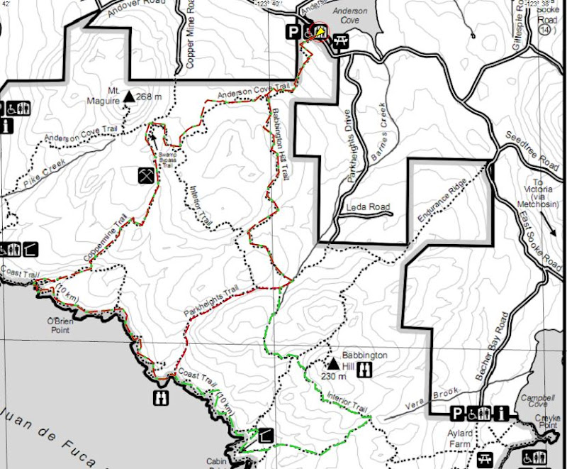
Anderson Cove parking lot, the trail begins just to the right of the big trail map. |
|
216m |
The first part of the trail heads uphill, there is a signpost at the top – turn LEFT towards Coast Trail (straight ahead is Park Boundary / Private Property) |
|
720m |
Go through a big old (hopefully) dry riverbed, signpost points back towards Anderson Cove and onward towards Coast Trail – head onward! |
|
1.7km |
At T-intersection at the top of the hill, turn RIGHT towards Mount Maguire. Signpost also points towards Coast Trail to your left and back towards Anderson Cove. |
|
2.2km |
Signpost with lots of signs: Coppermine Trail, Anderson Cove, Pike Rd, Mt Maguire; perpendicular: Interior Trail. Keep going STRAIGHT, don't turn onto Interior Trail. |
|
2.5km |
Signpost pointing back towards Anderson Cove, forwards to Mt Maguire, left to Swamp Bypass Trail; turn LEFT onto Swamp Bypass Trail. |
|
2.8km |
Swamp Bypass Trail opens out onto a big wide trail, turn LEFT towards Coast Trail. Signpost also points right to Coppermine Rd and Mt Maguire. |
|
3.3km |
Look to your right to see incredible mine shaft openings. There are at least two that we know of. Explore at your own risk!!! |
|
4.0km |
Don't step on the banana slug! |
|
4.5km |
A rushing creek crosses the trail, look to your RIGHT and find a bridge across it. Just past the creek a signpost points back towards Coppermine Rd, and both right & left towards Coast Trail. Keep to your RIGHT. |
|
5.0km |
Important intersection! Signpost points back to Anderson Cove, straight to Coast Trail and right towards Coast Trail, Iron Mine Bay & Pike Rd. Don't turn right! Stay STRAIGHT towards Coast Trail – do NOT cross a bridge. If you cross a bridge you went the wrong way, turn around! |
|
5.1km |
Very soon you'll see the ocean, there's a really nice lookout off to your right. A good place to stop for an energy bar or whatever :) Watch for seals! But most of it is just giant bull kelp... |
|
|
You're now on the Coast Trail, this is where you want to watch for yellow reflective markers to keep you on track. Other friendly trail-users have put piles of branches & rocks in the way of the “wrong” trails (the trail has changed due to windstorms), so if you are having to jump over major obstacles you're probably not on the right trail! The yellow markers are always on the correct trail; sometimes it's easier to find them if you look behind you. |
|
6.1km |
Signpost points left towards Coppermine Trail, back towards Iron Mine Bay & Pike Rd and forward towards Cabin Point. Stay STRAIGHT heading towards Cabin Point. |
|
6.5km |
After crossing a rocky creek, head uphill into the land of Spaghetti Trees! |
|
7.0km |
Watch for the bottom sections of 3 old metal fence poles on your right, you may also hear an occasional deep booming sound. Head towards the water, carefully look over the black rocky cliff into the crevasse & recognize the intense power of the open ocean crashing into a very narrow channel. BOOM! |
|
7.2km |
Important intersection! This is where the SHORT COURSE (12km) and LONG COURSE (16km) divide. Just after crossing a wooden bridge, SHORT COURSE turns LEFT uphill (signpost points toward Park Heights Rd). LONG COURSE stays STRAIGHT / SLIGHT RIGHT along Coast Trail towards Cabin Point & Aylard Farm, immediately crossing another wooden bridge. |
|
8.5km |
Signpost points left towards Interior Trail. Stay STRAIGHT towards Park Heights Rd. |
|
8.7km |
Signpost points right towards Interior Trail & Babbington Hill. Stay STRAIGHT towards Park Heights Rd. This is where the LONG COURSE joins up again. |
|
8.8km |
Signpost points left towards Anderson Cove & straight ahead towards Park Heights Rd. Turn LEFT towards Anderson Cove. |
|
9.9km |
Signpost keeps you on track, points you to the left towards Anderson Cove (there aren't any turnoffs here). |
|
11.2km |
Signpost where you've been before! Points back towards Coast Trail, straight ahead towards Mt Maguire & right to Anderson Cove. Turn RIGHT. |
|
11.9km |
Last signpost! Turn RIGHT towards Anderson Cove & head downhill into the parking lot. You're done! Time for burgers & beer :) |