Courses - Spaghetti Trees
Event Home | Registration | Backgrounder | Agenda
Course | Results | Thanks | Contact | FAQ
Short Course: ~12 - 13km
Please print out the course description (scroll down for printer friendly version) and bring it in a plastic baggie to the start.
CELL PHONES DO NOT WORK IN EAST SOOKE PARK, not even in the parking lot.
Hosts will have radios; if you have a radio or walkie-talkie that uses FRS, please bring it - we'll choose a frequency on the day.
Hosts will be sweeping the course. PLEASE BE CAREFUL & please make sure you have enough water, sustenance & a space blanket in case you get hurt and are waiting a while for help. Check out Action Jackson's "the ten essentials" list modified for trail running here: http://www.clubfatass.com/blog/ean-jackson/baggers-essential-companion.
SHORT COURSE
| 0m | Anderson Cove parking lot, the trail begins just to the right of the big trail map. |
| 216m | The first part of the trail heads uphill, there is a signpost at the top – turn LEFT towards Coast Trail (straight ahead is Park Boundary / Private Property) |
| 720m | Go through a big old (hopefully) dry riverbed, signpost points back towards Anderson Cove and onward towards Coast Trail – head onward! |
| 1.7km | At T-intersection at the top of the hill, turn RIGHT towards Mount Maguire. Signpost also points towards Coast Trail to your left and back towards Anderson Cove. |
| 2.2km | Signpost with lots of signs: Coppermine Trail, Anderson Cove, Pike Rd, Mt Maguire; perpendicular: Interior Trail. Keep going STRAIGHT, don't turn onto Interior Trail. |
| 2.5km | Signpost pointing back towards Anderson Cove, forwards to Mt Maguire, left to Swamp Bypass Trail; turn LEFT onto Swamp Bypass Trail. |
| 2.8km | Swamp Bypass Trail opens out onto a big wide trail, turn LEFT towards Coast Trail. Signpost also points right to Coppermine Rd and Mt Maguire. |
| 3.3km | Look to your right to see incredible mine shaft openings. There are at least two that we know of. Explore at your own risk!!! |
| 4.0km | Don't step on the banana slug! |
| 4.5km | A rushing creek crosses the trail, look to your RIGHT and find a bridge across it. Just past the creek a signpost points back towards Coppermine Rd, and both right & left towards Coast Trail. Keep to your RIGHT. |
| 5.0km | Important intersection! Signpost points back to Anderson Cove, straight to Coast Trail and right towards Coast Trail, Iron Mine Bay & Pike Rd. Don't turn right! Stay STRAIGHT towards Coast Trail – do NOT cross a bridge. If you cross a bridge you went the wrong way, turn around! |
| 5.1km | Very soon you'll see the ocean, there's a really nice lookout off to your right. A good place to stop for an energy bar or whatever :) Watch for seals! But most of it is just giant bull kelp... |
| You're now on the Coast Trail, this is where you want to watch for yellow reflective markers to keep you on track. Other friendly trail-users have put piles of branches & rocks in the way of the “wrong” trails (the trail has changed due to windstorms), so if you are having to jump over major obstacles you're probably not on the right trail! The yellow markers are always on the correct trail; sometimes it's easier to find them if you look behind you. | |
| 6.1km | Signpost points left towards Coppermine Trail, back towards Iron Mine Bay & Pike Rd and forward towards Cabin Point. Stay STRAIGHT heading towards Cabin Point. |
| 6.5km | After crossing a rocky creek, head uphill into the land of Spaghetti Trees! |
| 7.0km | Watch for the bottom sections of 3 old metal fence poles on your right, you may also hear an occasional deep booming sound. Head towards the water, carefully look over the black rocky cliff into the crevasse & recognize the intense power of the open ocean crashing into a very narrow channel. BOOM! |
| 7.2km | Important intersection! This is where the SHORT COURSE (12km) and LONG COURSE (16km) divide. Just after crossing a wooden bridge, SHORT COURSE turns LEFT uphill (signpost points toward Park Heights Rd). LONG COURSE stays STRAIGHT / SLIGHT RIGHT along Coast Trail towards Cabin Point & Aylard Farm, immediately crossing another wooden bridge. |
| 8.5km | Signpost points left towards Interior Trail. Stay STRAIGHT towards Park Heights Rd. |
| 8.7km | Signpost points right towards Interior Trail & Babbington Hill. Stay STRAIGHT towards Park Heights Rd. This is where the LONG COURSE joins up again. |
| 8.8km | Signpost points left towards Anderson Cove & straight ahead towards Park Heights Rd. Turn LEFT towards Anderson Cove. |
| 9.9km | Signpost keeps you on track, points you to the left towards Anderson Cove (there aren't any turnoffs here). |
| 11.2km | Signpost where you've been before! Points back towards Coast Trail, straight ahead towards Mt Maguire & right to Anderson Cove. Turn RIGHT. |
| 11.9km | Last signpost! Turn RIGHT towards Anderson Cove & head downhill into the parking lot. You're done! Time for burgers & beer :) |
Long Course - ~16 - 20(?) km
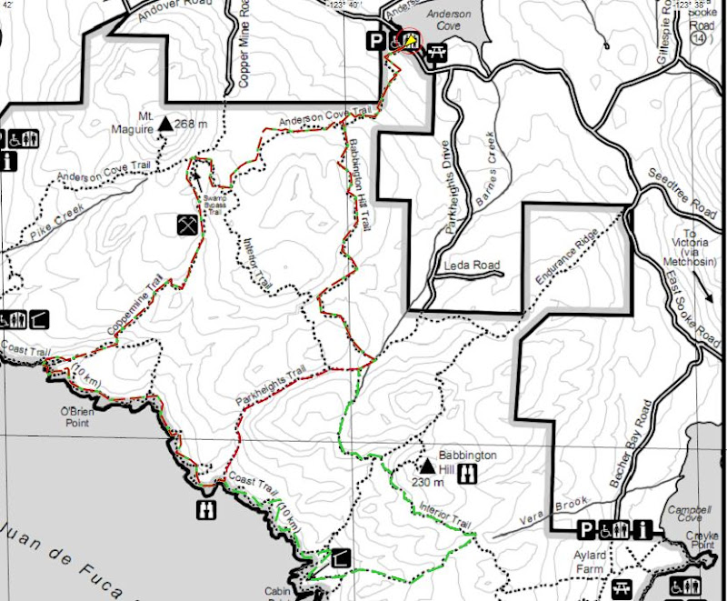
Please print out the course description (scroll down for printer friendly version) and bring it in a plastic baggie to the start. Printing the map is also Quite Helpful.
CELL PHONES DO NOT WORK IN EAST SOOKE PARK, not even in the parking lot.
Hosts will have a radio; if you have a radio or walkie-talkie, please bring it - we'll choose a frequency on the day. Hosts will be sweeping the course. PLEASE BE CAREFUL & please make sure you have enough water, sustenance & a space blanket in case you get hurt and are waiting a while for help. Check out Action Jackson's "the ten essentials" list modified for trail running here: http://www.clubfatass.com/blog/ean-jackson/baggers-essential-companion.
LONG COURSE
| 0m | Anderson Cove parking lot, the trail begins just to the right of the big trail map. |
| 216m | The first part of the trail heads uphill, there is a signpost at the top – turn LEFT towards Coast Trail (straight ahead is Park Boundary / Private Property) |
| 720m | Go through a big old (hopefully) dry riverbed, signpost points back towards Anderson Cove and onward towards Coast Trail – head onward! |
| 1.7km | At T-intersection at the top of the hill, turn RIGHT towards Mount Maguire. Signpost also points towards Coast Trail to your left and back towards Anderson Cove. |
| 2.2km | Signpost with lots of signs: Coppermine Trail, Anderson Cove, Pike Rd, Mt Maguire; perpendicular: Interior Trail. Keep going STRAIGHT, don't turn onto Interior Trail. |
| 2.5km | Signpost pointing back towards Anderson Cove, forwards to Mt Maguire, left to Swamp Bypass Trail; turn LEFT onto Swamp Bypass Trail. |
| 2.8km | Swamp Bypass Trail opens out onto a big wide trail, turn LEFT towards Coast Trail. Signpost also points right to Coppermine Rd and Mt Maguire. |
| 3.3km | Look to your right to see incredible mine shaft openings. There are at least two that we know of. Explore at your own risk!!! |
| 4.0km | Don't step on the banana slug! |
| 4.5km | A rushing creek crosses the trail, look to your RIGHT and find a bridge across it. Just past the creek a signpost points back towards Coppermine Rd, and both right & left towards Coast Trail. Keep to your RIGHT. |
| 5.0km | Important intersection! Signpost points back to Anderson Cove, straight to Coast Trail and right towards Coast Trail, Iron Mine Bay & Pike Rd. Don't turn right! Stay STRAIGHT towards Coast Trail – do NOT cross a bridge. If you cross a bridge you went the wrong way, turn around! |
| 5.1km | Very soon you'll see the ocean, there's a really nice lookout off to your right. A good place to stop for an energy bar or whatever :) Watch for seals! But most of it is just giant bull kelp... |
| You're now on the Coast Trail, this is where you want to watch for yellow reflective markers to keep you on track. Other friendly trail-users have put piles of branches & rocks in the way of the “wrong” trails (the trail has changed due to windstorms), so if you are having to jump over major obstacles you're probably not on the right trail! The yellow markers are always on the correct trail; sometimes it's easier to find them if you look behind you. | |
| 6.1km | Signpost points left towards Coppermine Trail, back towards Iron Mine Bay & Pike Rd and forward towards Cabin Point. Stay STRAIGHT heading towards Cabin Point. |
| 6.5km | After crossing a rocky creek, head uphill into the land of Spaghetti Trees! |
| 7.0km | Watch for the bottom sections of 3 old metal fence poles on your right, you may also hear an occasional deep booming sound. Head towards the water, carefully look over the black rocky cliff into the crevasse & recognize the intense power of the open ocean crashing into a very narrow channel. BOOM! |
| 7.2km | Important intersection! This is where the SHORT COURSE (~12km) and LONG COURSE (~16km) divide. Just after crossing a small wooden bridge, LONG COURSE stays STRAIGHT / SLIGHT RIGHT along Coast Trail towards Cabin Point & Aylard Farm, immediately crossing another wooden bridge. SHORT COURSE turns LEFT uphill (signpost points toward Park Heights Rd). |
| 7.5km | The trail is difficult to find here: fallen trees on either side, trail heads straight up & over mossy rocks. No yellow markers around (until after you're up & over & look behind you) |
| On this part of the Coast Trail, keep looking for yellow trail markers and don't cross over piles of branches / rocks – these probably indicate you're going the wrong way! | |
| 8.3km | There is a well-defined trail off to your left but it's WRONG! Stay straight ahead down some mossy rocks, you will be very unbelieving that you're on the correct trail (look behind you & you'll see yellow markers to help convince you). Don't worry too much, if you take the wrong trail here you'll still end up in the same place, you'll just end up running through a very overgrown salal-y trail. |
| 8.5km | Signpost: you're on Coast Trail, back the way you came is Iron Mine Bay & Pike Rd, to the left uphill is Babbington Hill, and to your right is Aylard Farm & Cabin Point. Turn RIGHT towards Cabin Point. [If you took the wrong turn at the previous instruction, you'll have to turn left down the wide trail to get to this signpost – it's fairly obvious] |
| 8.8km | Cabin Point... head down to the cabin & take a look. We think it's a little freaky! When you're done, come back & turn right (left if you didn't bother heading down to the cabin). A little ways along the trail will be another signpost indicating you are on Coast Trail, back toward Cabin Point, forward to Beechy Head and left to Aylard Farm. Turn LEFT toward Aylard Farm. |
| 8.9km | Signpost: points back toward Cabin Point, slight left to Aylard Farm. Turn LEFT toward Aylard Farm. |
| 10.1km | Signpost: points back toward Cabin Point, right to Aylard Farm, left to Babbington Hill. Turn LEFT toward Babbington Hill. |
| 11.0km | Signpost points forward & back along Interior Trail, to your right is Babbington Hill. Unless you're really bustin' for a challenge, we recommend NOT climbing Babbington Hill. Stay STRAIGHT along Interior Trail. |
| 11.2km | Confusing intersection!! Signpost with lots of signs: Interior Trail, Coast Trail, Cabin Point, back to Aylard Farm, right to East Sooke Rd. Take a SLIGHT LEFT, then RIGHT to basically stay STRAIGHT on Interior Trail. |
| 12.1km | Signpost points back the way you came for Interior Trail & Babbington Hill, right toward Anderson Cove & Park Heights Rd, left toward Coast Trail. Turn RIGHT toward Anderson Cove, in less than 100m (at next signpost) turn LEFT towards Anderson Cove. |
| 13.3km | Signpost keeps you on track, points you to the left towards Anderson Cove (there aren't any turnoffs here). |
| 14.6km | Signpost where you've been before! Points back towards Coast Trail, straight ahead towards Mt Maguire & right to Anderson Cove. Turn RIGHT. |
| 15.3km | Last signpost! Turn RIGHT towards Anderson Cove & head downhill into the parking lot. You're done! Time for burgers & beer :) |
Course - Bike To Start (from Ferry Terminal, 65km or Switch Bridge, 35km)
Please print out the course description (scroll down for printer friendly version) and bring it in a plastic baggie to the start. If you get lost, bail out or need assistance you can call Katie at 250.415.7314
From Swartz Bay ferry terminal on your bike (meet @ 09:00):
Ride off the ferry along with the cars and follow the road out of the ferry terminal.
Just after you exit the ferry terminal, you'll see a small trail (possibly paved, I can't remember!) heading up to your right with a little sign for bicycles. (If you start heading downhill on the highway you've missed this turnoff, but you can get to the same place by turning right at the very first road - it's actually a highway entrance but you can ride your bike along the side). You need to get up to the overpass which you will have just ridden under. Go up and turn right onto the overpass and wait here to meet any other cyclists!, on the other side are signs pointing you towards Lochside trail, which runs alongside the road for the first part.
Keep following signs all the way along Lochside trail, it is well sign-posted. There is one confusing part where you'll turn right and be heading towards the highway with a McDonald's on your left; there is a tiny sign on the left-turn pullout about 25m before you reach the highway that indicates you need to turn left to continue on the trail.
On this trail you will never cross the highway at a stoplight; if you end up doing that you're not on the trail! It does cross at least one road with a stoplight (McKenzie Rd) but never a highway.
The trail sometimes follows roads and sometimes is really a trail.
Eventually (after about 25k) you will get to a place with multiple trail options, there will be a signpost showing the Centennial Trail system / Lochside & Galloping Goose trails You want to get to the Switch Bridge on the map - you won't be going over the Switch Bridge, instead you will turn right just before it to continue to Sooke on the Galloping Goose trail.
Don't turn off Lochside trail until just before the Switch Bridge - there is another signpost map at this location, and you'll know if you're going over the Switch Bridge because it's a steep on-ramp and you'll be up over cars! If you end up there, turn back & get on the correct trail.
Turn right to get onto the Galloping Goose trail.
From the Switch Bridge on your bike (meet at 11:00):
(if the folks who rode from the ferry get there before 11:00, please do your best to wait for those who will be joining you @ the Switch Bridge)
Stay on the Goose all the way into Sooke - watch for instructions at any road crossing. About 30km from the Switch Bridge (that you didn't cross!), the Goose will cross over Gillespie Rd where you will turn left (the trail will continue straight), you are about 5km from the trailhead at Anderson Cove parking lot.
Stay on Gillespie Rd until a T-intersection where you'll turn R onto East Sooke Rd.
Stay on East Sooke Rd until you pass a sign on your right telling you it's 200m until the Anderson Cove parking lot for East Sooke Regional Park; the parking lot itself will be on your left.
Unfortunately I'm pretty sure there are no bike racks in the parking lot (oh dear!) but we can lock several bikes together or put them into other members' cars.