Spaghetti Trees
Event Home | Registration | Backgrounder | Agenda
Course | Results | Thanks | Contact | FAQ
This run is seriously gorgeous. It's short-ish but challenging & the rewards are great (both the scenery & the post-run location!). The 12.30p start time allows people from Vancouver to arrive & depart in the same day, if desired (but everybody should just stay in Victoria 'cause it's so darn great).
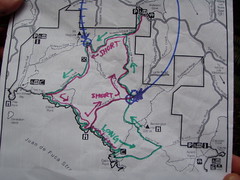
Routes
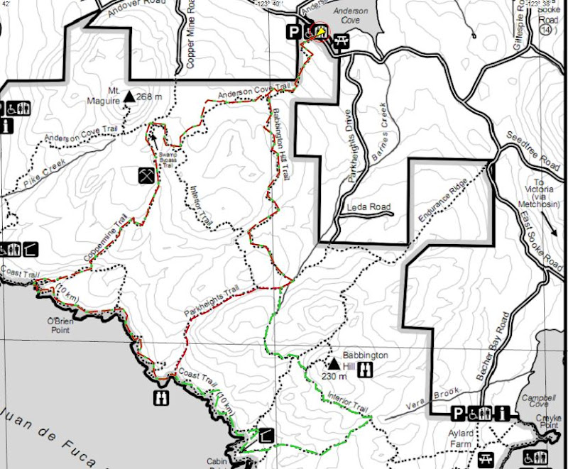
The routes are 12.5km & 16km according to the GPS but both feel longer in terms of how much time they take, but also feel like nothing at all because the scenery & trails are so amazing you might not even notice you're running!
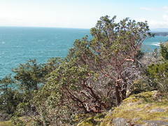
Both routes start & end together, both have LOTS of up & down and both follow the fantastic Coast Trail for part of the route. The Coast Trail in this park is a continuation of the world-famous West Coast Trail, along the westernmost edge of Vancouver Island. The maximum elevation for both is only about 200m, but have lots of ascent & descent in between. Both routes go past hundred-year-old coppermine entrances, which you can explore if you want (bring a flashlight...).
The short route has 500m total ascent in 12.5km.
The long route has nearly 900m ascent in 16km, follows a longer portion of the Coast Trail, and goes past a crazy old slightly eerie fishing cabin.
Both routes end with a visit to a 120-year-old pub for grub (burgers, clam chowder served in an entire sourdough loaf) and beer (check out the Victoria craft brewing scene!). They also have nice warm bathrooms to change in... [17 Mile Pub in Sooke]
The event is timed so people from Vancouver can arrive & depart in the same day, if desired.
Why is it called Spaghetti Trees??? hmmmm... It always happens on the Saturday closest to April Fool's Day, is that something to do with it?
It's a Fat Ass event: No aid. No t-shirt. No special marking. No whining! Lots of fun.
When and Where?
-
Saturday, 30 March 2013 (closest Saturday to April Fool's Day) at 12:30 (mid-day start allows ferry-takers time to get here and back again), East Sooke Regional Park near Victoria, BC: Anderson Cove entrance. Accessible by bike, car & public transit (sort of...). Carpooling is the best way, hooray for multi-seated vehicles!
-
You can get here & back in the same day from Vancouver, but you might want to think about staying over before or after the run & making a weekend of it. The 9a ferry from Tsawwassen will get you here in time, with a very teensy bit of time to spare for traffic, getting lost or a very quick coffee / snack stop. If you want a bit more time to look around Victoria on a beautiful Saturday morning, take the 7a ferry. Carpooling is a great plan, as is making a vehicle reservation for the ferry (if you're taking the 7a ferry you probably don't need a reservation, but I would recommend it for the 9a!). You should have plenty of time to catch the 7p ferry back to Vancouver after a short pub visit, or stay a bit longer after the run and get a BCAA discount for taking the 9p ferry (last sailing of the day). You won't need a reservation on the way back (Saturday night is usually pretty quiet on BC ferries), but if you're a worrier, might as well make one :) BC Ferries Website for more schedule info & reservations
-
The start is *sort of* accessible by public transit (the bus will get you within 8km & we'll help you carpool the rest of the way) - get in touch if you're thinking about taking the bus, we'll give you more details. Another option for the non-car-user is Pacific Coach Lines (which has pretty good student discounts) to get you at least into downtown Victoria.
-
If you're really crazy and want to add-in a lovely bike ride on the fabulous traffic-free Galloping Goose trail, choose between 30km (from the "Switch Bridge" in Victoria) or 65km (from the Swartz Bay / Victoria ferry terminal) to the start (or anywhere in between). Indicate this on your registration form & we'll put you in touch with any other takers so you can figure out when & where to start your ride.
-
See agenda for details on how to get there and course description, & check out teagirl's BC Ferries Travel Tips and teagirl & carguy's Beer Map of Victoria (sadly out of date now that we've moved away...)
Who is Running?
- Check out the Registration List
How Much?
- Free for Club Fat Ass members (click here for current membership benefits and dues). Membership just for the day is available.
- Please sign up for both the club membership and the free event online and in advance. This will allow us to keep the membership fees low and the logistics before the event to a minimum.
Registration - Spaghetti Trees
Thank you for registering online and in advance.
This is a Club Fat Ass (CFA) event, so we adhere to CFA event management guidelines and privacy policy. Please complete the whole form. Your personal information is needed to make sure I spell your name right in the results and so I can contact you... or your next of kin! The other information helps me to plan any aid or post-event activities. Please help me to host a safer, better event by registering early and by notifying me if you can't make it. I'm constantly looking for ways to improve, so please share your thoughts or questions with me in the Suggestion Box below. After you click on "submit" below, your registration details will be confirmed.
Your Club Fat Ass Event Host
Agenda - Spaghetti Trees
Event Home | Registration | Backgrounder | Agenda
Course | Results | Thanks | Contact | FAQ
| Saturday, 30 March 2012 | |
|
in the AM (depends if you're catching a ferry, & which one!) www.bcferries.com for schedules & reservations. |
Have breakfast. Check the weather. Print off this agenda and your route instructions. Catch the ferry +/- get on your bike. |
|
11:30a |
Arrive at the start - Anderson Cove parking lot, East Sooke Rd (see map below) |
|
11:45a |
Welcome and final briefing |
|
11:55a |
Photo |
|
Noon |
Start |
|
1:30p |
First finishers of the ~13k route |
| 2:30p | First finishers of the ~20k route |
|
~3:00p |
Post-run food, beer & awards at 17 Mile House Pub (www.17milehouse.com). Plan to take the bus home if consuming much alcohol! We can also continue the party @ teagirl & carguy's place, a map will be provided @ the pub |
|
5:00p |
Last finishers (hopefully!) |
What to Bring?
- Aid. (Whatever food, water or electrolyte drink you need for a 90+ minute run. If you expect and are prepared for no external aid, you may be pleasantly surprised... but do not count on it!)
-
weather appropriate clothing... layer, layer, layer.
-
PLEASE bring a foil emergency blanket just in case - it is light, costs less than $5 at mec / cdn tire, and you'll REALLY appreciate it if you need it.
-
Please bring a walkie-talkie if you have one that uses FRS (most do these days unless they cost < $10) - cell phones DO NOT WORK in East Sooke Park.
-
Official timing system. (A watch will do, even if the second hand doesn't work.) Please be sure to keep track of your finish time and to give it to the timekeeper.
-
CHANGE OF CLOTHES!
-
Sleeping bag & thermarest-type-thing if planning to sleep on Carlos' floor
Post Run Gathering
After the run we'll meet up at 17 Mile House Pub: you passed it on your way in, just east of the intersection of Gillespie Rd & Sooke Rd (Hwy 14). There is parking on both sides of the street, but I recommend parking in the small lot across the street from the pub so you don't have turn turn left out of the pub (it's a bit hazardous). Don't drink & drive - there IS public transit from this pub into Victoria if necessary. They have good food, a fairly good beer list (although not the BEST selection in Victoria, for that you have to go to Christie's pub in Oak Bay, or The Beagle in Cook Street Village, or even Crossroads Pub in Colwood which is on the way back to Victoria, in case you're left unsatisfied by 17 Mile House!), it's a really neat building built in 1864, and they have big warm bathrooms to change in :)
We'll do awards at the pub once most folks have gotten there.
How to Get To the Start, via various modes of transport:
From Swartz Bay ferry terminal / Victoria, driving:
Google Map
(If you Google Map this yourself it will give you some theoretically more direct back-road options but: the route described below and shown on the Google Map linked above is the EASIEST way to get there; taking back roads is a good way to get lost!)
Head south along Pat Bay Highway (Hwy 17 - you're on it as soon as you get off the ferry).
After about 25km, take the exit for McKenzie Road to get to Hwy-1 (Exit 7 towards Nanaimo / Sooke).
Turn right off McKenzie to head North on Hwy-1. If you're coming from Victoria, just get to here from wherever you are.
Take exit 14 towards Langford / Sooke. Stay in the Sooke lane. Ignore the confusing sign that says "Peake Rd to your R, Sooke to your L" - just keep going straight all the way through the strip malls and don't turn until you get to Sooke Rd at which point you'll turn right.
Drive along fun windy Sooke Rd for awhile. Eventually you'll see 17 Mile House Pub on your right - take note, this is where we'll purchase food & beverages after the run.
ALMOST IMMEDIATELY after 17 Mile House, you will be turning left - this comes up FAST so watch for it. There's a teeny tiny left-turn lane and a teeny-tiny signpost that says "East Sooke". If you miss this turn you have to come back to it 'cause it's the only way to get to East Sooke.
You'll now be on Gillespie Rd, stay on it until a T-intersection where you'll turn R onto East Sooke Rd.
Stay on East Sooke Rd until you pass a sign on your right telling you it's 200m until the Anderson Cove parking lot for East Sooke Regional Park; the parking lot itself will be on your left.
From Swartz Bay ferry terminal / Victoria by public transit:
Outside the ferry terminal foot passenger exit will be some busses waiting to pick people up. Get on bus #70, Downtown Express.
If you're hoping to get your bike onto the bus, ask a ferry employee when you're getting off the ferry how to get up to the bus stop (you ride your bike off the ferry with the traffic, but the bus stop is up on a higher level where the foot passenger exit is; there's an elevator but it's too hard for me to describe how to find it!).
Tell the bus driver you'll be wanting to catch the #50 for Langford and ask where you should get off in order to do that.
From Victoria you can catch a #50 bus on Douglas St downtown, heading north.
Catch a #50 Langford bus - they come every 15 to 30 minutes. Ask the driver if he'll be continuing as a #61 to Sooke (some of them do, some of them don't; if it does you don't have to switch buses again!). Take the bus to Langford Exchange.
Get on a #61 to Sooke. Ask the driver to drop you off at 17 Mile Pub. This is the closest you can get to East Sooke Regional Park on a Saturday on public transit - you are 8km away. We will organize a car or two to pick people up at 17 Mile Pub as long as we know you're planning to take public transit! Please note it when you register and we will get in touch to arrange details. PLEASE let us know ahead of time (eg. 2-3 days) so that we don't miss anybody!
From Swartz Bay ferry terminal on your bike:
Ride off the ferry along with the cars and follow the road out of the ferry terminal.
Just after you exit the ferry terminal, you'll see a small paved trail heading up to your right with a little sign for bicycles. (If you start heading downhill on the highway you've missed this turnoff, but you can get to the same place by turning right at the very first road - it's actually a highway entrance but you can ride your bike along the side). You need to get up to the overpass which you will have just ridden under. Go up and turn right onto the overpass, on the other side are signs pointing you towards Lochside trail, which runs alongside the road for the first part.
Keep following signs all the way along Lochside trail, it is well sign-posted. There is one confusing part where you'll turn right and be heading towards the highway with a McDonald's on your left; there is a tiny sign on the left-turn pullout about 25m before you reach the highway that indicates you need to turn left to continue on the trail.
On this trail you will never cross the highway at a stoplight; if you end up doing that you're not on the trail! It does cross at least one road with a stoplight (McKenzie Rd) but never a highway.
The trail sometimes follows roads and sometimes is really a trail.
Eventually (after about 25k) you will get to a place with multiple trail options, there will be a signpost showing the Centennial Trail system / Lochside & Galloping Goose trails You want to get to the Switch Bridge on the map - you won't be going over the Switch Bridge, instead you will turn right just before it to continue to Sooke on the Galloping Goose trail.
Don't turn off Lochside trail until just before the Switch Bridge - there is another signpost map at this location, and you'll know if you're going over the Switch Bridge because it's a steep on-ramp and you'll be up over cars! If you end up there, turn back & get on the correct trail.
Turn right to get onto the Galloping Goose trail.
From the Switch Bridge on your bike:
Stay on the Goose all the way into Sooke - watch for instructions at any road crossing. About 30km from the Switch Bridge (that you didn't cross!), the Goose will cross over Gillespie Rd where you will turn left onto the road (the bike trail will continue straight), you are about 5km from the trailhead at Anderson Cove parking lot.
Stay on Gillespie Rd until a T-intersection where you'll turn R onto East Sooke Rd.
Stay on East Sooke Rd until you pass a sign on your right telling you it's 200m until the Anderson Cove parking lot for East Sooke Regional Park; the parking lot itself will be on your left.
Unfortunately I'm pretty sure there are no bike racks in the parking lot (oh dear!) but we can lock several bikes together or put them into other members' cars.
Other Notes
-
please read the FAQ (Frequently Asked Questions)
-
please, please, please do not drop litter on the trail. (Consider picking it up if you find any.)
-
this event is not sponsored, sanctioned, permitted or anything else that would qualify it as an official event. It's a party!
-
be sure to bring a copy of the course directions for the event you are attempting. We recommend you put them in a baggie so they don't turn to mush.
Courses - Spaghetti Trees
Event Home | Registration | Backgrounder | Agenda
Course | Results | Thanks | Contact | FAQ
Short Course: ~12 - 13km
Please print out the course description (scroll down for printer friendly version) and bring it in a plastic baggie to the start.
CELL PHONES DO NOT WORK IN EAST SOOKE PARK, not even in the parking lot.
Hosts will have radios; if you have a radio or walkie-talkie that uses FRS, please bring it - we'll choose a frequency on the day.
Hosts will be sweeping the course. PLEASE BE CAREFUL & please make sure you have enough water, sustenance & a space blanket in case you get hurt and are waiting a while for help. Check out Action Jackson's "the ten essentials" list modified for trail running here: http://www.clubfatass.com/blog/ean-jackson/baggers-essential-companion.
SHORT COURSE
| 0m | Anderson Cove parking lot, the trail begins just to the right of the big trail map. |
| 216m | The first part of the trail heads uphill, there is a signpost at the top – turn LEFT towards Coast Trail (straight ahead is Park Boundary / Private Property) |
| 720m | Go through a big old (hopefully) dry riverbed, signpost points back towards Anderson Cove and onward towards Coast Trail – head onward! |
| 1.7km | At T-intersection at the top of the hill, turn RIGHT towards Mount Maguire. Signpost also points towards Coast Trail to your left and back towards Anderson Cove. |
| 2.2km | Signpost with lots of signs: Coppermine Trail, Anderson Cove, Pike Rd, Mt Maguire; perpendicular: Interior Trail. Keep going STRAIGHT, don't turn onto Interior Trail. |
| 2.5km | Signpost pointing back towards Anderson Cove, forwards to Mt Maguire, left to Swamp Bypass Trail; turn LEFT onto Swamp Bypass Trail. |
| 2.8km | Swamp Bypass Trail opens out onto a big wide trail, turn LEFT towards Coast Trail. Signpost also points right to Coppermine Rd and Mt Maguire. |
| 3.3km | Look to your right to see incredible mine shaft openings. There are at least two that we know of. Explore at your own risk!!! |
| 4.0km | Don't step on the banana slug! |
| 4.5km | A rushing creek crosses the trail, look to your RIGHT and find a bridge across it. Just past the creek a signpost points back towards Coppermine Rd, and both right & left towards Coast Trail. Keep to your RIGHT. |
| 5.0km | Important intersection! Signpost points back to Anderson Cove, straight to Coast Trail and right towards Coast Trail, Iron Mine Bay & Pike Rd. Don't turn right! Stay STRAIGHT towards Coast Trail – do NOT cross a bridge. If you cross a bridge you went the wrong way, turn around! |
| 5.1km | Very soon you'll see the ocean, there's a really nice lookout off to your right. A good place to stop for an energy bar or whatever :) Watch for seals! But most of it is just giant bull kelp... |
| You're now on the Coast Trail, this is where you want to watch for yellow reflective markers to keep you on track. Other friendly trail-users have put piles of branches & rocks in the way of the “wrong” trails (the trail has changed due to windstorms), so if you are having to jump over major obstacles you're probably not on the right trail! The yellow markers are always on the correct trail; sometimes it's easier to find them if you look behind you. | |
| 6.1km | Signpost points left towards Coppermine Trail, back towards Iron Mine Bay & Pike Rd and forward towards Cabin Point. Stay STRAIGHT heading towards Cabin Point. |
| 6.5km | After crossing a rocky creek, head uphill into the land of Spaghetti Trees! |
| 7.0km | Watch for the bottom sections of 3 old metal fence poles on your right, you may also hear an occasional deep booming sound. Head towards the water, carefully look over the black rocky cliff into the crevasse & recognize the intense power of the open ocean crashing into a very narrow channel. BOOM! |
| 7.2km | Important intersection! This is where the SHORT COURSE (12km) and LONG COURSE (16km) divide. Just after crossing a wooden bridge, SHORT COURSE turns LEFT uphill (signpost points toward Park Heights Rd). LONG COURSE stays STRAIGHT / SLIGHT RIGHT along Coast Trail towards Cabin Point & Aylard Farm, immediately crossing another wooden bridge. |
| 8.5km | Signpost points left towards Interior Trail. Stay STRAIGHT towards Park Heights Rd. |
| 8.7km | Signpost points right towards Interior Trail & Babbington Hill. Stay STRAIGHT towards Park Heights Rd. This is where the LONG COURSE joins up again. |
| 8.8km | Signpost points left towards Anderson Cove & straight ahead towards Park Heights Rd. Turn LEFT towards Anderson Cove. |
| 9.9km | Signpost keeps you on track, points you to the left towards Anderson Cove (there aren't any turnoffs here). |
| 11.2km | Signpost where you've been before! Points back towards Coast Trail, straight ahead towards Mt Maguire & right to Anderson Cove. Turn RIGHT. |
| 11.9km | Last signpost! Turn RIGHT towards Anderson Cove & head downhill into the parking lot. You're done! Time for burgers & beer :) |
Long Course - ~16 - 20(?) km
Please print out the course description (scroll down for printer friendly version) and bring it in a plastic baggie to the start. Printing the map is also Quite Helpful.
CELL PHONES DO NOT WORK IN EAST SOOKE PARK, not even in the parking lot.
Hosts will have a radio; if you have a radio or walkie-talkie, please bring it - we'll choose a frequency on the day. Hosts will be sweeping the course. PLEASE BE CAREFUL & please make sure you have enough water, sustenance & a space blanket in case you get hurt and are waiting a while for help. Check out Action Jackson's "the ten essentials" list modified for trail running here: http://www.clubfatass.com/blog/ean-jackson/baggers-essential-companion.
LONG COURSE
| 0m | Anderson Cove parking lot, the trail begins just to the right of the big trail map. |
| 216m | The first part of the trail heads uphill, there is a signpost at the top – turn LEFT towards Coast Trail (straight ahead is Park Boundary / Private Property) |
| 720m | Go through a big old (hopefully) dry riverbed, signpost points back towards Anderson Cove and onward towards Coast Trail – head onward! |
| 1.7km | At T-intersection at the top of the hill, turn RIGHT towards Mount Maguire. Signpost also points towards Coast Trail to your left and back towards Anderson Cove. |
| 2.2km | Signpost with lots of signs: Coppermine Trail, Anderson Cove, Pike Rd, Mt Maguire; perpendicular: Interior Trail. Keep going STRAIGHT, don't turn onto Interior Trail. |
| 2.5km | Signpost pointing back towards Anderson Cove, forwards to Mt Maguire, left to Swamp Bypass Trail; turn LEFT onto Swamp Bypass Trail. |
| 2.8km | Swamp Bypass Trail opens out onto a big wide trail, turn LEFT towards Coast Trail. Signpost also points right to Coppermine Rd and Mt Maguire. |
| 3.3km | Look to your right to see incredible mine shaft openings. There are at least two that we know of. Explore at your own risk!!! |
| 4.0km | Don't step on the banana slug! |
| 4.5km | A rushing creek crosses the trail, look to your RIGHT and find a bridge across it. Just past the creek a signpost points back towards Coppermine Rd, and both right & left towards Coast Trail. Keep to your RIGHT. |
| 5.0km | Important intersection! Signpost points back to Anderson Cove, straight to Coast Trail and right towards Coast Trail, Iron Mine Bay & Pike Rd. Don't turn right! Stay STRAIGHT towards Coast Trail – do NOT cross a bridge. If you cross a bridge you went the wrong way, turn around! |
| 5.1km | Very soon you'll see the ocean, there's a really nice lookout off to your right. A good place to stop for an energy bar or whatever :) Watch for seals! But most of it is just giant bull kelp... |
| You're now on the Coast Trail, this is where you want to watch for yellow reflective markers to keep you on track. Other friendly trail-users have put piles of branches & rocks in the way of the “wrong” trails (the trail has changed due to windstorms), so if you are having to jump over major obstacles you're probably not on the right trail! The yellow markers are always on the correct trail; sometimes it's easier to find them if you look behind you. | |
| 6.1km | Signpost points left towards Coppermine Trail, back towards Iron Mine Bay & Pike Rd and forward towards Cabin Point. Stay STRAIGHT heading towards Cabin Point. |
| 6.5km | After crossing a rocky creek, head uphill into the land of Spaghetti Trees! |
| 7.0km | Watch for the bottom sections of 3 old metal fence poles on your right, you may also hear an occasional deep booming sound. Head towards the water, carefully look over the black rocky cliff into the crevasse & recognize the intense power of the open ocean crashing into a very narrow channel. BOOM! |
| 7.2km | Important intersection! This is where the SHORT COURSE (~12km) and LONG COURSE (~16km) divide. Just after crossing a small wooden bridge, LONG COURSE stays STRAIGHT / SLIGHT RIGHT along Coast Trail towards Cabin Point & Aylard Farm, immediately crossing another wooden bridge. SHORT COURSE turns LEFT uphill (signpost points toward Park Heights Rd). |
| 7.5km | The trail is difficult to find here: fallen trees on either side, trail heads straight up & over mossy rocks. No yellow markers around (until after you're up & over & look behind you) |
| On this part of the Coast Trail, keep looking for yellow trail markers and don't cross over piles of branches / rocks – these probably indicate you're going the wrong way! | |
| 8.3km | There is a well-defined trail off to your left but it's WRONG! Stay straight ahead down some mossy rocks, you will be very unbelieving that you're on the correct trail (look behind you & you'll see yellow markers to help convince you). Don't worry too much, if you take the wrong trail here you'll still end up in the same place, you'll just end up running through a very overgrown salal-y trail. |
| 8.5km | Signpost: you're on Coast Trail, back the way you came is Iron Mine Bay & Pike Rd, to the left uphill is Babbington Hill, and to your right is Aylard Farm & Cabin Point. Turn RIGHT towards Cabin Point. [If you took the wrong turn at the previous instruction, you'll have to turn left down the wide trail to get to this signpost – it's fairly obvious] |
| 8.8km | Cabin Point... head down to the cabin & take a look. We think it's a little freaky! When you're done, come back & turn right (left if you didn't bother heading down to the cabin). A little ways along the trail will be another signpost indicating you are on Coast Trail, back toward Cabin Point, forward to Beechy Head and left to Aylard Farm. Turn LEFT toward Aylard Farm. |
| 8.9km | Signpost: points back toward Cabin Point, slight left to Aylard Farm. Turn LEFT toward Aylard Farm. |
| 10.1km | Signpost: points back toward Cabin Point, right to Aylard Farm, left to Babbington Hill. Turn LEFT toward Babbington Hill. |
| 11.0km | Signpost points forward & back along Interior Trail, to your right is Babbington Hill. Unless you're really bustin' for a challenge, we recommend NOT climbing Babbington Hill. Stay STRAIGHT along Interior Trail. |
| 11.2km | Confusing intersection!! Signpost with lots of signs: Interior Trail, Coast Trail, Cabin Point, back to Aylard Farm, right to East Sooke Rd. Take a SLIGHT LEFT, then RIGHT to basically stay STRAIGHT on Interior Trail. |
| 12.1km | Signpost points back the way you came for Interior Trail & Babbington Hill, right toward Anderson Cove & Park Heights Rd, left toward Coast Trail. Turn RIGHT toward Anderson Cove, in less than 100m (at next signpost) turn LEFT towards Anderson Cove. |
| 13.3km | Signpost keeps you on track, points you to the left towards Anderson Cove (there aren't any turnoffs here). |
| 14.6km | Signpost where you've been before! Points back towards Coast Trail, straight ahead towards Mt Maguire & right to Anderson Cove. Turn RIGHT. |
| 15.3km | Last signpost! Turn RIGHT towards Anderson Cove & head downhill into the parking lot. You're done! Time for burgers & beer :) |
Course - Bike To Start (from Ferry Terminal, 65km or Switch Bridge, 35km)
Please print out the course description (scroll down for printer friendly version) and bring it in a plastic baggie to the start. If you get lost, bail out or need assistance you can call Katie at 250.415.7314
From Swartz Bay ferry terminal on your bike (meet @ 09:00):
Ride off the ferry along with the cars and follow the road out of the ferry terminal.
Just after you exit the ferry terminal, you'll see a small trail (possibly paved, I can't remember!) heading up to your right with a little sign for bicycles. (If you start heading downhill on the highway you've missed this turnoff, but you can get to the same place by turning right at the very first road - it's actually a highway entrance but you can ride your bike along the side). You need to get up to the overpass which you will have just ridden under. Go up and turn right onto the overpass and wait here to meet any other cyclists!, on the other side are signs pointing you towards Lochside trail, which runs alongside the road for the first part.
Keep following signs all the way along Lochside trail, it is well sign-posted. There is one confusing part where you'll turn right and be heading towards the highway with a McDonald's on your left; there is a tiny sign on the left-turn pullout about 25m before you reach the highway that indicates you need to turn left to continue on the trail.
On this trail you will never cross the highway at a stoplight; if you end up doing that you're not on the trail! It does cross at least one road with a stoplight (McKenzie Rd) but never a highway.
The trail sometimes follows roads and sometimes is really a trail.
Eventually (after about 25k) you will get to a place with multiple trail options, there will be a signpost showing the Centennial Trail system / Lochside & Galloping Goose trails You want to get to the Switch Bridge on the map - you won't be going over the Switch Bridge, instead you will turn right just before it to continue to Sooke on the Galloping Goose trail.
Don't turn off Lochside trail until just before the Switch Bridge - there is another signpost map at this location, and you'll know if you're going over the Switch Bridge because it's a steep on-ramp and you'll be up over cars! If you end up there, turn back & get on the correct trail.
Turn right to get onto the Galloping Goose trail.
From the Switch Bridge on your bike (meet at 11:00):
(if the folks who rode from the ferry get there before 11:00, please do your best to wait for those who will be joining you @ the Switch Bridge)
Stay on the Goose all the way into Sooke - watch for instructions at any road crossing. About 30km from the Switch Bridge (that you didn't cross!), the Goose will cross over Gillespie Rd where you will turn left (the trail will continue straight), you are about 5km from the trailhead at Anderson Cove parking lot.
Stay on Gillespie Rd until a T-intersection where you'll turn R onto East Sooke Rd.
Stay on East Sooke Rd until you pass a sign on your right telling you it's 200m until the Anderson Cove parking lot for East Sooke Regional Park; the parking lot itself will be on your left.
Unfortunately I'm pretty sure there are no bike racks in the parking lot (oh dear!) but we can lock several bikes together or put them into other members' cars.
Results - Spaghetti Trees
Event Home | Registration | Backgrounder | Agenda
Course | Results | Thanks | Contact | FAQ
2013 Spaghetti Trees Results
(well, 3, and then 4... ahem, Jackal, what time is it??)
Report: Spaghetti Trees 2013
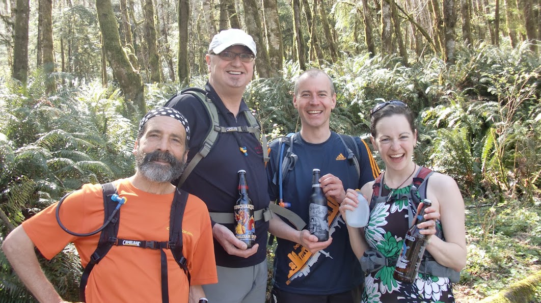
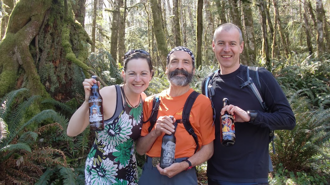
We had a smaller group than previous years (probably because of Easter weekend, and silly ol' Vancouverites who are scared of taking ferries!) but those of us who ran had an AMAZING time. The weather was spectacularly spectacular, couldn't have been better. Sunny but not too hot... kept those Lighthouse beers nice & cool, anyway! [Thank you Lighthouse Brewing for sponsoring our run, the runners & volunteers were very happy about that!]
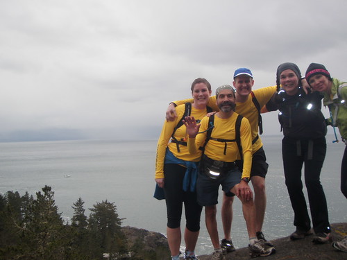
 Carlos the Jackal & Stefan (a CFA newbie!) ran 8k to the start from 17 Mile Pub. They got to the start super early, and when Teagirl & her entourage arrived (husband, 7.5-month-old baby) Carlos somehow managed to convince them it was time to go RIGHT NOW even though it was actually 1/2 hour early! And unfortunately with Teagirl's baby brain, she didn't quite figure out the time problem until about 15 minutes later... So we took a 3-runner starter photo & headed out - but after a kilometre or so Teagirl & Stefan figured it out & made Jackal run back because Kirk (another CFA newbie!) was waiting for us at the start. And then Teagirl & Stefan decided to run back as well because they decided water was boring & wanted to run with some beer :) [disclaimer: no potential illegal consumption of beverages shall be associated with our club or our wonderful sponsors... not that there was any illegal consumption or anything...]
So we took another starter photo, with the 4 people who'd actually let us know they'd be running (despite some website difficulties...) & headed out again. This time, everything was going really well until Teagirl's baby brain struck again and she turned left instead of right at an important intersection, meaning we were doing the route backwards. Which was fine, except there was a surprise aid station (hooray! Placed by Teagirl's husband Brendan, accessed along with baby in offroad jogging stroller) meant to be reached at km 9ish but which we instead hit at km 4ish. That was ok with us though, we were ready for a break. And we were even able to point it out to another runner who happened to be in the right place at the right time & got to benefit from the water, bananas & oranges in the middle of the forest. We didn't share any beer though. Because we weren't drinking on the trail OF COURSE!
Kirk (who competed in Sailing in the 1996 Paralympics in Atlanta & taught us about wind & currents as we ran along above the water) hadn't been doing a tonne of trail running lately, so thought he might just cut it short once we saw the ocean. But that Coast trail is just so gorgeous, we all kept running & did the entire short route together (backwards). Which according to Stefan's GPS is 14k (plus 2k extra for Carlos' out-&-back at the beginning). Took us all about 3ish hours - it's a looong 14k...
We saw beautiful vistas, scary copper mine shafts, an aircraft carrier, a few other runners & folks walking with dogs, and of course lots of Spaghetti Trees.


The post-run venue had to be changed from 17 Mile Pub to Stickleback restaurant in Sooke, because Teagirl's daughter is still a minor (for the next 18.5 years...) & the pub couldn't let her in. That was fine 'cause Stickleback is excellent! We look forward to another post-run gathering there in the future!
Stories were told, songs were sung, prizes were distributed, yummy food was eaten & yummy beer was drunk & then we headed out into the gorgeous sunshine to enjoy the rest of the long weekend.
We're already looking forward to next time :)
Here's some awesome video Carlos took with his nifty new toy! Please click the link below if the video doesn't work...
Your host: Teagirl Katie
Photos of the event can be uploaded to Flickr, added to the CFA Flickr group and tagged with SpaghettiTrees, SpaghettiTrees2013 ClubFatAssEvents ClubFatassEvents2013. Instructions on how to add them via Flickr are here. They will automatically be added to the slideshow linked below (coming soon):
Feedback: We welcome and encourage your feedback and comments via the comment form below. Please also take a moment to fill in this brief post event survey.
Thanks to Lighthouse Brewing for yummy beer; Stickleback West Coast Eatery for more yummy (Lighthouse!) beer, yummy food, a great location & super-helpful staff & TrailRunner mag for the two free subscriptions!
Results:
| Runner | Distance | Time | Points |
| Teagirl Katie (Katie Longworth) |
16ish km (short route backwards + Carlos' out-&-back) |
3h35min | 2 + 2** + 1* |
| The Jackal (Carlos Castillo) |
32ish km (from pub, short route backwards + Carlos' out-&-back, back to pub) |
4h20min | 2 |
| Stefan Lehmann |
24ish km (from pub, short route backwards + Carlos' out-&-back) |
4h27min | 1 |
| Kirk Westergaard | 14ish km (short route, backwards!) | 3h40min | 1 |
* Bonus Point for garbage collection
** Host Points
*** membership status
2011 Spaghetti Trees Results

(none of whom are looking at the correct camera... very appropriate to this event!)
(comment from teagirl's husband: WHAT THE HE** ARE YOU WEARING!? Sigh. Good grief. Can't let you out in public...)
Report:
Ah, the lovely sound of rain, rain, rain...
No way! Nuh-uh! Not on our Spaghetti Trees!!
East Sooke Regional Park worked its magic yet again with a brilliantly sunny day beginning about 10 minutes after the start time for Spaghetti Trees 2011. It drizzled in the morning (and on & off all day in Victoria & Vancouver!) but as soon as the clock struck noon and the Spaghettiers got going, Mr. Sun shone down on us on the south-west coast of Vancouver Island for hours & hours (...& hours...!).
One of our fearless leaders was unfortunately unable to come out this year because she had her hands all over the hot bodies of the national swim team - in a purely registered-massage-therapist clinical sense, of course! 
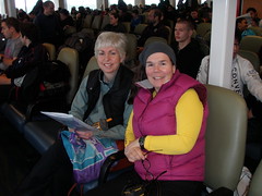
The two brave gals from Vancouver made it *just* in time from the 9am ferry. After some issues with self-timers & cameras, we managed to get at least one sort-of OK starter photo! We got going at 12:04; lucky Sibylle got to do an extra few hundred metres up & down & up again locating the dropped-in-the-parking-lot walkie-talkie, and then it was off to the races. Teagirl stayed behind to wait for a possible cyclist from Vancouver, WA (yikes, that's a long way to ride a bike!), and then she eventually gave up & snuck away to do her sneaky Spaghetti Trees trick-or-treating... 
The token male & his harem (!) (one of whom found out about Spag Trees in TrailRunner mag, then googled it & signed up! Hooray for print media & teh interwebs!) managed to find their way to the scary copper mines, past a "surprise" aid station & out to the stunningly beautiful open-ocean vistas. They soon learned that one of the most challenging things on this run (and there are many challenges on this run!!) is keeping your eyes on the trail when there is so much gosh-darn jaw-dropping beauty around every corner. The sunlight on the ocean, the sound of the crashing waves, the eagles, the ravens... not to mention, of course, the Spaghetti Trees!
The Vancouver gals didn't quite find their way, making up their own custom course, sort of backwards, sort of sideways; you know, whatever, man! They found the second surprise aid station just as it came into being & made good use of portable technology to take a picture of the "you are here" map-in-a-ziploc, then continued on toward the scary old (haunted??) fishing cabin.
Teagirl meandered through the sunlit forest, braving encounters with bulldozers, giant puddles & large (& very small) barking dogs. Plenty of time for a cup of tea & a purchase of frozen Galloping Goose sausages ("Boerewors" & "Loukanikos") for dinner from "Bill's Food & Feed" in the Middle Of Nowhere, East Sooke.
Eventually it felt like time to take down the aid stations... unfortunately, #2 was removed a bit prematurely so Jackal & The Gals didn't get any water, bananas, oranges, Mike & Ikes, Hershey's Caramel Kisses (mmm, caramel) or "chocolate-covered graham crunch thingies" before heading along the Interior & Babbington Hill trails back to Anderson Cove - but they were still laughing / crying about the hotly contested "stay STRAIGHT" instruction, and before they knew it they were barrelling down the last steep section of trail into the parking lot where hot tea (of course!) and more nibblies awaited them. Teagirl & Jackal finally made radio contact about 5 minutes before we all ended up in the same place...
We started to get cold pretty fast since the lovely sun was heading quickly lower in the west, so we stuffed our mouths, left a note for Sibylle & Pat (who had adamantly told us, "Don't wait for us"... we made a plan that if we hadn't heard *anything* from them by 6pm we'd alert the necessary authorities) & headed to the fantastic 17 Mile House Pub who had been holding a table for us for over an hour... oops! It's ok, it wasn't actually busy!
We had a great time chatting with our Antipodean waitress & getting to know the mostly new-to-CFA runners & their significant others who joined us at the pub. Wonderful beery & trail-runner-y prizes were distributed with much laughter (Kathleen's rendition of Cat Stevens' "Miles From Nowhere" & Elaine's "The Wonderful Thing About Tiggers" stand out in my memory). Sibylle & Pat showed up just before 5p so we could rest easy knowing they were safe & on their way to catch the 7p ferry which apparently they did in plenty of time. The rest of us enjoyed yummy pub grub & pints of fresh ale before heading out into the sunshine... which, about 10 minutes later, turned into one of the heaviest downpours I have ever seen!
But that's how it goes at Spaghetti Trees...
Maybe next year you'll experience the magic too!? We look forward to seeing you there!
Check out Carlos the Jackal & Sibylle's videos of the event:
http://www.clubfatass.com/blog/carlos-castillo/spaghetti-trees-token-male
Your hosts:
Teagirl (Katie) & Lysanne (absentee hostess-avec-le-mostest)
Photos of the event can be uploaded to Flickr, added to the CFA Flickr group and tagged with SpaghettiTrees, SpaghettiTrees2011 ClubFatAssEvents ClubFatassEvents2011. Instructions on how to add them via Flickr are here. They will automatically be added to the slideshow linked below:
Feedback: We welcome and encourage your feedback and comments via the comment form below. Please also take a moment to fill in this brief post event survey.
Thanks to 17 Mile House Pub, Sooke for holding our table; TrailRunner mag for the two free subscriptions; The Jackal & Action Jackson for fueling teagirl's Need for Beer (p.s. it has been / will be shared with husbind CarGuy & Lysanne + Her Handsome Man); Frontrunners Victoria, The Running Room @ Millstream & Discovery Coffee, Oak Bay for hosting our lovely hand-drawn-on-construction-paper posters.
Results:
So, the GPS says the "Long Run" is 16km... but it does take a REALLY long time to run it... so we all kind of feel like it must be more. But then again, there is a LOT of up & down. So maybe it is "technically" only 16km. But seriously. This is a LONG run. A long, gorgeous, fantastic, once-in-a-lifetime if it's a spectacular sunny day in early spring, run...
Don't miss out!
| First Name | Last Name | City | Distance | Points | Time | |||
|---|---|---|---|---|---|---|---|---|
| Elaine | Galbraith | Victoria | 20km | 2 | 3:52 | |||
| The | Jackal | Victoria | 20km | 2+1* | 3:52 | |||
| lisa | hoffner | victoria | 20km | 2 | 3:52 | |||
| Kathleen | Birney | Victoria | 20km | 2 | 3:52 | |||
| Katie | Longworth | Victoria | custom + tea break! | 2+2** | ||||
| Valerie | Bell | Victoria | 20km | 2 | 3:52 | |||
| Sibylle | Tinsel | North Vancouver | Creative Custom | 2+1* | 4:37 | |||
| Patricia | Barry | Vancouver | Creative Custom | 2 | 4:37 | |||
| Deana | (can't remember her last name right now!) | Vancouver, WA | 30km bike + Short Run | x | DNS | |||
* Bonus Point for garbage collection
** Host Points
*** membership status
Harvesting Spaghetti Trees
Pat and I were the only mainlanders following teagirl's call to harvest Spaghetti Trees in East Sooke Park this past Saturday. A shame really, as the scenery, trails and superb event hosting by Katie make this a must-do trip for any Fat Ass worth their trail shoes ;-)
 The trip does require a bit of planning, but can comfortably done in a day. For me, it involved getting up at 5:00am to catch the 6:30 Seabus from the North Shore to downtown Vancouver, then on via the Canada Line Skytrain to Oakridge station, where Pat's blue Happy Car just pulled around the corner. I threw in my knapsack and we continued to catch the 9am ferry from Tsawwassen to Swartz Bay on Vancouver Island. If you plan to participate next year, you can safely leave a bit later.
The weather forecast had predicted a mix of sun and clouds, chance of rain and clearing in the afternoon. The skies were threatening, but we were hopeful that the clearing skies would coincide with our run. Just off the ferry, it started to rain...
 It took us a little longer than 1h to find Anderson Cove in East Sooke Park. Katie's instructions on the website were stellar and we pulled into the parking lot with about 10min to spare (note to self, next year have everything ready in the running pack to avoid forgetting items or having them in wrong pockets). We quickly semi organized our packs and greeted the Victoria contingent of Club Fat Ass around Katie and Carlos. A nice bunch, I would have loved to chat a bit more with them, but we instructed Katie and Carlos, to not "chaperon" the turtle pacers, Pat and myself. Last year, Carlos ran with the mainlanders and guided us along the course, but this year, I didn't want to slow down any body and felt confident to find the trails. Pat and I were out to complete the course, not beat any speed records.
As on cue, the sun came out and off we went, climbing out of the parking lot through a mossy forest. We soon lost sight of the group around Carlos as we were still zipping up pockets and securing the wardrobe and packs... At the first intersection, I consulted the course description (where are my glasses), but at the second turn, I confidently veered left without looking at the written description. The trails was very wet and more like a river in long stretches. I mentioned to Pat, that I remembered the trail from the return trip last year. I also mentioned that I didn't remember running down this wet single track last year. As we should find out later, my memory served me right. We continued on the zig zagging trail. Pat was hoping to soon see the ocean, and I assured her that the approach to the ocean was a long one and we will first pass old copper mines.
 Eventually, I started to doubt we were on the correct trail and when the next intersection did not line up with Katie's trail description my fears were confirmed. Time to dig out my reading glasses. We determined that we were running the route in reverse. Oops. Running time was 1:20 at this point and there was no way we would loop back. Decision was made to continue in reverse. To our surprise we ran into Katie just a couple of metres up the trail, setting up an aid station. Katie confirmed our suspicions, fed us some bananas and saw us off on our creative custom reverse course.
The trail started to descend towards cabin point. Did I smell salty air and ocean? As discussed with Katie, for time reasons, we opted to cut off the Babbington Hill loop and headed straight for cabin point and the shore line. Soon we caught glimpses of the ocean and greeted cabin point in the distance before continuing north west along a cliff high above the Pacific.
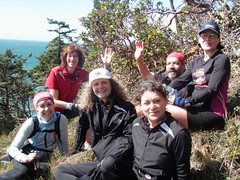 My heart sank when I saw the climb down the mossy rocks... I do not like heights and this was too open, steep and airy for my taste. Without Pat coaxing me down, I would have happily turned around and ran home ;-) Thanks Pat. Half way sliding down on my bum, we saw Carlos and his group climbing up towards us. I instructed them to stay where they were, as I couldn't possibly squeeze by a bunch of bodies on this exposed stretch. Everybody had a good laugh, and we congregated on a big rock for a group photo. Before parting, somebody mumbled something about another nasty, airy climb not to far further. No way, why did I not have any recollection of this from last year? Sure enough, I had a few more heart stopping moments descending towards the frothy ocean, but Pat's presence prevented me from turning around and bolting. How could I have said to her that the trail wasn't technical at all, just much longer than anticipated and lots of up and downs...selective memories for sure.
The views were marvelous. The sun was shining and the wind was whipping up huge thundering waves below us. Picture perfect weather for a run along this shore line. We saw a couple of mating cormorants and kept looking for whales (no such luck). We also came across a few large animal prints and disturbed, dug up, moss... hm, the only other human we saw was a lone hiker...
We passed the intersection for the short course and continued on the longer Coast Trail savouring the views. Katie had mentioned another short cut option, taking the first instead of the second turnoff on the Copper Mine Trail. Given that we were much slower than anticipated (and the ferry wouldn't wait), we cut off the last coastal section and said our goodbyes to the ocean.
The return trip let us through Spaghetti Tree forests and past a couple of old copper mines. More rivers to cross and wet trails to navigate, but lots of runnable terrain. We even came across another aid station set up by Katie complete with oranges, bananas and arrows on where to go. Nice.
We found a good rhythm for our last 5 or so km and happily greeted the car at the parking lot. Katie had left another note for us requesting a check in at the pub or a phone call - my yes, we wouldn't drive past the pub without saying Hi...too bad that we most likely would not have time for Burgers and some greasy fries. Sorry Islanders, we would have liked to share a pint and some trail stories with you. In the end, we probably could have stayed a bit longer as we arrived at the empty ferry terminal with 60min to spare.
To all mainlanders, you want to pencil this one into your calendar. It's doable in a day trip and if we organize a car pool in a mini van, the cost for the ferry comes down considerably.
Spaghetti Trees by the Token Male
This was my second running of the soon to be Spring "Classic".
Kate had managed to convince the weather Gods to shine on us.
I was running with four well prepared women, the nuclius of which was my Sunday long run group, plus one brave newbie to CFA and my group of "usual suspects".
Luckily we were all about the same pace so we could hang together well and there was little or no regrouping stops needed.
We did stop to see the old copper mine, the Island and ocean view at Iron Mine bay and we had a little wander around in the cabin at Cabin Point.
The trails had a fair amount of surface water, and in parts we were running either upstream or down stream.In one case we ran up and down the same stream as Elaine was taking the word "straight" to mean straight.... 'nuf said.
We all congrgated in the 17 mile House on the Sooke Rd. for beer food and prizes.
Yes prizes!
I was the First male finisher.(incidentally also the last " Long Course" finisher!)
Here is the link to my seven minute video of the event.
I think you will see that we took full advantage of our brief window of opportunity.(weather wise...)
ILTS!
http://www.youtube.com/watch?v=SJpTyZ76XU0
2010 Spaghetti Trees Results
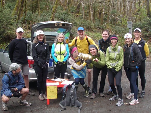
After an inauspicious day-before-the-run with the (first!?) Great Windstorm of 2010, 11 brave runners met up without trepidation to brave the always-wild trails of East Sooke Regional Park. Four of them had been up since 4am to carpool from Vancouver, catching the 1st ferry of the day and even managing to watch one of the heats of the Brown Cup at Elk Lake (THE springtime UBC / UVic rowing event) before booting it out to East Sooke. Another Vancouverite drove down from Nanaimo where he was spending the Easter weekend with his family - he took the morning ferry from Horseshoe Bay on the day of the storm and that was the last boat to leave West Vancouver all day! He just had to get to Spaghetti Trees...
We also had a few CFA newbies, who had a bit of trouble registering on the website but foresaw that the run was going to be a good one so they came out & joined in.
And it's a good thing they did! We had a very enthusiastic group at the start including (of course) the golden pig (who still remains formally nameless??). After visits to the outhouse, which one of our hosts had somehow falsely remembered as an actual flush toilet with running water (oops!) and assignments of walkie talkies to various members of the group (Channel 13, 3 - good numbers), we were off. Lysanne's pal Patty agreed to hang out near the parking lot & guard the loot cars. Unfortunately 2 registrants didn't make it to the start – did they get lost? It is a bit out-of-the-way...
Carlos the Jackal volunteered to sweep the 16k leaving the hosts free to run wild from the the start, joined by a speedy Doug McConnell who gave us a run for our money right up until he suddenly turned left and we realized he was doing the 12k (he actually ended up being the only one to do that route for reasons that will be explained below...). He finished close to an hour before anyone else and decided to head back up to Nanaimo - a good 2-hour drive each way! Thanks for coming out, Doug!
A surprise unmanned aid station greeted us a few km into the race with water, a map and Powerbar "goodies", then it was do-o-o-own the Coppermine trail past the creepy old mine entrances to the Coast trail.
Somewhere along the route we realized there are really no "flat" sections, you're either going up (or straight up!) or down (or straight down!) the whole time... which of course, for trail runners, is why we love it. One of the great challenges of this course is keeping your eyes on the trail when there are so many fantastic things to see... including the Spaghetti Trees! Somehow the whole carload of Vancouverites managed to miss them - they'll just have to come back next year & try again!
The weather cooperated swimmingly. After the crazy winds the day before we were concerned that the trails might be a bit more difficult to navigate than before, but while there were definitely a few more downed trees than a few weeks previous, it was all pretty much par for the course in this generally wind-swept land - there are so many ancient windfallen trees everywhere that it's hard to tell when the newer ones fell anyway...
Every so often the walkie-talkies would crackle, keeping the frontrunners in (sort of) communication with the sweep group. We had a great time after the run figuring out what we had actually been saying to one another as opposed to what we heard! Thankfully we didn't end up needing the walkie-talkies for any emergency situations, although we hope in that event we would be able to get the message across to “get to high ground, I really really need to talk to you”.
Teagirl was feeling slow after Cabin Point but Lysanne egged her on by singing silly songs (in direct contravention of Jackal's instructions at the start: “No singing on this run!”) and finding lots of Easter Bunny tails that looked suspiciously like moss.
Elaine & Fergus were steadily motoring along, then “decided” that 16k was just not enough and added a little extra out-&-back to their run – after this they (literally?!) ran into the Jackal's sweep group consisting of everyone else.
Jackal had not-quite-on-purpose managed to prevent anyone in his group from running the 12k (even though many of them had planned to do so!) by saying “No, no, that's not where you turn to do the short route, we just keep on going along here...”; but everyone was quite happy at the end that they did they whole thing.
The Vancouverite Vanpool-of-Fun crazies took about 22 million photos which will be posted to Flickr for all to enjoy.
The rain that had been threatening all day held off until everyone made it back to the parking lot (this actually happens every time the hosts run here; it's as if there's a special signal - “my run is finished, it's ok to rain now!”) where we piled into cars & headed for 17 Mile House pub with the exception of Fergus who had 7 missed calls on his phone... apparently his family hadn't realized the run would take ALL afternoon! So he & Linda headed off to assuage the concerns.
While we drank good beer & ate really good pub grub, prizes were handed out for “best never-done-a-CFA-run-before story” (Elaine), “best performance of the song that was going through your head during the whole run” (Claudia & Reagan), “super-excellent-fantastic sportsmanpersonship” (Carlos the Jackal & Lysanne), “best guarding of cars EVER” (Patty) and “best organizing & implementation of a vanpool from the Lower Mainland” (Kat & Sibylle). Prizes included run-y stuff from Trailrunner mag, Asics, Brooks & Sugoi AND beverages from fantastic Victoria craft breweries Phillips, Swan's & Canoe (the bevvies weren't donated but the brewers deserve props for creating these works of art... we'll work on getting them donated for next year!).
The vanpool had to rush off to catch their 9pm ferry and the islanders stuck around just a little while longer before braving the rainy, windy (and windy... make those 2 words sound different so you understand the meanings!) road back from Sooke to the “real” world. A rather successful day indeed.
If you still haven't seen a Spaghetti Tree, you'll just have to do it again (or come do it for the first time) next year!
Your hosts:
teagirl (Katie) & Lysanne
Photos of the event can be uploaded to Flickr, added to the CFA Flickr group and tagged with SpaghettiTrees, SpaghettiTrees2010 ClubFatAssEvents ClubFatassEvents2010. They will automatically be added to the slideshow linked here: ccc
Video: Jackal not only guided the city boys and girls expertly, he also produced a video in record time. Sibylle says hers is in the making...
Feedback: We welcome and encourage your feedback and comments via the comment form below. Please also take a moment to fill in this brief post event survey.
Results:
| First Name | Last Name | Points | Event | Time |
| Doug | McConnell | 2 | 12km | 02:05 |
| Lysanne | Lavigne | 4* ** | 16km | 02:51 |
| Katie | Longworth | 4* ** | 16km | 02:56 |
| Reagan | White | 3* | 16km | 03:39 |
| Carlos | the Jackal | 3* | 16km | 03:40 |
| Kathryn | Webb | 3* | 16km | 03:40 |
| Sibylle | Tinsel | 3* | 16km | 03:40 |
| Claudia | Bullington | 3* | 16km | 03:41 |
| Linda | Tyrrell | 2 | 16km | 03:41 |
| Fergus | M | 2 | ~16km | 03:41 |
| Elaine | Galbraith | 2 | ~16km | 03:41 |
| Patty | 1 | car guard! | ||
| Tanya | Berg | -1 | DNS | |
| Kristy | Hillen | -1 | DNS |
* Bonus Point for garbage collection
** Shared Event Host Points
*** membership status
Backgrounder - Spaghetti Trees
Event Home | Registration | Backgrounder | Agenda
Course | Results | Thanks | Contact | FAQ
Why this run?
This run was started in 2010 by 2 new-ish CFAers who wanted to share their new-ish discovery of how gorgeous East Sooke Park is with other CFAers. At the time they both lived in Victoria and wanted to show of the beautiful trails they get to train on. In the meantime, teagirl (Katie) has moved to North Van and temporary delegated hosting to Vancouver Island original, Carlos Castillo.
Routes
Both routes start & end together, both have LOTS of up & down and both follow the fantastic Coast Trail for part of the route. The Coast Trail in this park is a continuation of the world-famous West Coast Trail. The maximum elevation for both is only about 200m, but have lots of ascent & descent in between! Both routes go past hundred-year-old coppermine entrances, which you can explore if you want to!
The short route has 500m total ascent in 12.5km.
The long route has nearly 900m ascent in 16km, follows a longer portion of the Coast Trail, and goes past a crazy old fishing cabin that teagirl finds a bit eerie.
The Differences
- This event follows the guidelines provided by Club Fat Ass for safe and successful, informal endurance sports "parties":
- It is free for Club members
- It is hosted by a Club member
- It is small and informal. Guests should come prepared for the weather and the terrain and not expect aid or course marking. They should expect to follow detailed written course instructions
- It is environmentally friendly. We aim to leave our route in better shape than it was before we passed though.
- It is as much about the camaraderie as the competition.
Guests at the event download from the Internet directions based on natural and physical landmarks. As with orienteering, those who aren't familiar with the course will pause frequently to consult the written directions, giving a slight competitive advantage to those who have trained on it. Course directions are available year 'round on the agenda page of this website and we encourage everyone to enjoy the route as often as they please throughout the year.
Past Participants and Results
Results and a scrapbook of photos and comments are archived under Results
FAQ - Spaghetti Trees
Event Home | Registration | Backgrounder | Agenda
Course | Results | Thanks | Contact | FAQ
| Q: | coming soon |
| A: | |
| Q: | |
| A: | |
| Q: | |
| Q: | If I decide to run, what should I bring? |
| A: | Whatever you'd normally wear for a run of that distance given the conditions. Don't forget to print out the run route directions, directions to the start and to bring a cell phone. |
| Q: | Are there aid stations? Can I have a beer en route? |
| A: | We recommend you come prepared to run without external aid. Since this is an 'unofficial' event, there are no rules as to what you may or may not eat or drink en route. |
| Q: | |
| A: | |
| Q: | What can I win? |
| A: | Nothin. Fastest man and woman TO FINISH THE COURSE get bragging rights. |
| Q: | I've never done a trail run before. Is this a good place to start? |
| A: | |
| Q: | How tough is the course? |
| A: | Tough question to answer! Which course are you running? How fast? How well are you trained? xxxx |
| Q: | Do I really need to print off the course instructions and bring them with me? |
| A: | Yes. Without the detailed instructions or an intimate familiarity with the Night Run route, you're almost certain to get lost. |
| Q: | This event is free, but for Club Fat Ass members only. How do I get into the club? |
| A: | There is no hazing ceremony like the Hash House Harriers! Runners, walkers, hikers, triathletes, adventure racers, mountain bikers and anyone else interested in having fun in the great outdoors is welcome and can register online for a nominal fee. |
| Q: | Can I wait until the last minute and join at the start? |
| A: | Yes, but we prefer you don't. Last minute registration makes it very difficult to organize and coordinate the event. There is also a $5.00 "Day of Event" surcharge for day-of-event members who don't pre-register on the website. |
| Q: | It's a free world. What's to stop me from just running the course. |
| A: | Nothing...in fact, we encourage you to run the course often in training! We prefer that you do not 'bandit' the course on event day, however. If you insist, please don't take any of the aid intended for members. You will not get recognition in the results or be eligible for any draw prizes and you'll have to wear a black patch over one eye at the potluck. Furthermore, you won't be allowed into future events until you come clean with past membership dues. |
| Q: | What if I get lost? |
| A: |
You shouldn't get lost, but bring a cell phone, just in case. |
| Q: | Do I get credit for any time I spend off-course? |
| A: | Are you kidding? If you do find an obvious mistake in the course directions, point it out to Katie. |
| Q: | Couldn't you mark the course like just about every other running race I've ever been in? It's a pain to pause and read instructions. |
| A: | Our aim is to be different than every other running race you've ever been in! We don't want to put chalk/flour on the ground, hang surveyor tape in the trees, paint rocks, put up signs or glow sticks or do anything that might leave a trace of the race. Besides, it slows down the faster runners. |
| Q: | What is the 'Rule of the Trail'? |
| A: | If you pack it in, you can pack it out. (That means don't you dare litter!) Leave nothing but your footprints on the trail. We strongly encourage you to pick up any trash you find along the trail. There may be a recognition award for the person who packs out more than they packed in. |
| Q: | What if I have to heed the call of nature. |
| A: | There are washrooms at xxx |
| Q: | Can I bring my friends and family to the party even if they didn't run or volunteer? Do they have to be Club Fat Ass members? |
| A: | Friends and family are absolutely welcome and no, they do not have to be Club Fat Ass members. Please be sure to specify how many guests you will bring with you on your registration form. |
Thanks - Spaghetti Trees
Event Home | Registration | Backgrounder | Agenda
Course | Results | Thanks | Contact | FAQ
Our hope is to make this event totally self-supporting. In other words, do all of the organization beforehand and also participate. This would be an impossible dream without a lot of behind the scenes help. Many thanks to:
.JPG) Kintec Footlabs
Kintec Footlabs
Thank you for the awesome recognition prizes and participating in the run.
Sibylle Tinsel - Club Fat Ass www.ClubFatAss.com: Club Fat Ass helps the race with web hosting, online registration and coaches us on how to host a safe, fun, environmentally-friendly event.
Please contact us with your thoughts.
Contact - Spaghetti Trees
Course | Results | Thanks | Contact | FAQ
I welcome your comments, criticisms, feedback and questions.
Please be sure to read the the Agenda and FAQ section of this website first, as this is where I've tried to answer the most frequently asked questions.
Teagirl Katie - Your CFA Event Hosts
Confirmation - Spaghetti Trees
The following people are registered for this event:1) teagirl katie! (long_run)
2) Carlos Castillo (long_run)
3) Stefan Lehmann (long_run)
Post Event Survey - Spaghetti Trees
Please take a moment to share your thoughts about the Club Fat Ass event you recently participated in. Your feedback will help your Event Host to refine their event next year.
This is an anonymous, confidential survey (as long as you are not logged in to the website) so please feel free to offer constructive criticism about any aspect of the event in the comment box.