 The stars lined up to see my friend Pat, my 12 year old son and 14 year old second cousin visiting from Germany ready for an assault on Mount Strachan and Hollyburn this past Thursday.
The forecast was for possible thunder showers in the afternoon and the morning dawned hot, humid and ominously dark. A quick check of my email showed that Pat didn't cancel or question the weather.
The 4 of us piled into our car and drove to the main parking lot on Cypress Mountain. The bugs were ferocious and the boys immediately and liberally used the bug spray that I luckily had packed. According to little Jackson the spray did not deter the little blood sucking monsters...
 Once on the trail we right away came to an intersection nicely marked with a wooden post and trail markers pointing us to the Howe Sound Crest Trail East/Lions and the Howe Sound Crest Trail West. I had never notice the sign before and doubted that I wanted to go East, but did want to head towards the Lions until reaching the turn off up to Mount Strachan. Against my intuition we took the east trail that wound it's way uphill on a nice, rooty trail that spat us out on a gravel ski run. Hm, I had come down from Strachan on the ski run last year and it wasn't my favorite memory. Suggested to my group to turn around and follow the other trail. The boys weren't too happy about extra distance (200m or so ;-) but I stuck to my guns... only to find out that both trail actually met after a few 100m. A couple of hikers behind us did exactly the same maneuver...the trail marking post needs a bit of work to make this clearer.
 The next hurdle came, when the trail we were on swept us onto a newly rigged up gravel trail, "forcing" us across a little bridge and up an embankment away from the old trail and the direction I knew was right. Since the old trail looked decommissioned and the new trail was set up in a way that it was logical to follow it (go there and you'll see what I mean) we veered steeply up and followed this highly engineered path. Nobody seemed too enthused about the big gravel rocks lining the trail as we wound our way steeply uphill via countless switchbacks. I couldn't recall gaining that much altitude that early on the Howe Sound Crest Trail and again suggested to turn around. Boys were not impressed. On the descent we met a couple that mentioned something about working for the park but being of work. They thought the new trail was built to use "Olympic money" and that the old trail was no longer maintained. Nice use of funds: replacing a trail that in my memory was perfectly fine with an ugly monstrosity. The nice couple called somebody that was supposed to know if we were on the correct trail. The person on the other end confirmed that the switchback trail connected with the old HSCT and that we could veer off just after the third switchback...Well, my boys were reaching boiling point. "mom, we are hardly hiking for 10min and you got us lost 5 times already". Hang on a second, I wasn't lost, just trying to reconcile my trail knowledge with these newly minted trails and poor signage.
 We counted 8 or 9 switchbacks until we finally reached the intersection with the old HSCT. I happily recognized the old trail and the mood among the boys rose slightly. At (what I believe is Strachan Meadows and Strachan Creek) we took a small, hardly visible trail right, away from the main trail. If you do this hike, make sure you are not following the creek bed, but the path to the left of it.
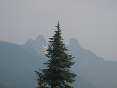
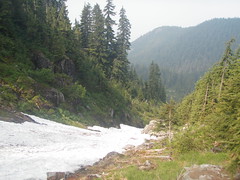
The wildflowers on our scramble up were spectacular. The boys had fun pelting us with ice balls made from left over snow patches in the creek gully. The views were rather disappointing because of the smoke from the rampant BC wild fires, but luckily the poor air quality did not affect my asthma. I was huffing and puffing alright, but I think it was related to the climb ;-)
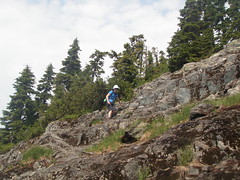
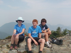
Eventually, the trail flattens out on a little saddle between the north and the south peak. The north peak is the true peak and we dutifully climbed through purple heather bushes to the rocky peak, despite the boys wanting to take the direct route home... Lunch never tasted that good and mercifully we had left most of the black flies somewhere below us...or maybe I swatted them all to death.
 While the boys never got far ahead on the ascent, their patience was tested on the descent..."book it mom!" I hear
from somewhere below a few times. The boys were not to keen on continuing to Hollyburn and deliberately led us away from where we suspected the connecting trail was...Hollyburn has to wait until next time. In retrospect, finding that trail and adding a bit of distance and climbing would have been much better than trying to scramble down the ski run. What an awful way to end a hike... and shame on the powers (whoever is in charge of trails and signage) for bulldozing a new trail into the mountain, but not maintaining the signage to help hikers find a trail off Strachan. We were not the only ones having ended up on the ski hill.


Comments
Nice!
Looks like the decent through the scree & ski slope was well worth it, great job bagging!